
McIntosh County, North Dakota facts for kids
Quick facts for kids
McIntosh County
|
|
|---|---|

McIntosh County Courthouse in Ashley
|
|

Location within the U.S. state of North Dakota
|
|
 North Dakota's location within the U.S. |
|
| Country | |
| State | |
| Founded | March 9, 1883 (created) October 4, 1884 (organized) |
| Named for | Edward H. McIntosh |
| Seat | Ashley |
| Largest city | Wishek |
| Area | |
| • Total | 995 sq mi (2,580 km2) |
| • Land | 975 sq mi (2,530 km2) |
| • Water | 20 sq mi (50 km2) 2.0% |
| Population
(2020)
|
|
| • Total | 2,530 |
| • Estimate
(2022)
|
2,475 |
| • Density | 2.543/sq mi (0.9817/km2) |
| Time zone | UTC−6 (Central) |
| • Summer (DST) | UTC−5 (CDT) |
| Congressional district | At-large |
McIntosh County is a county located in the state of North Dakota in the United States. In 2020, about 2,530 people lived there. The main town and county seat is Ashley.
McIntosh County is special because it has the highest percentage of German-Americans in the whole United States. In 2010, more than 76% of the people living here had German family roots!
Contents
History of McIntosh County
The county was created on March 9, 1883, by the government of the Dakota Territory. It was formed from parts of other counties and some areas that didn't belong to any county yet.
The county was named after Edward H. McIntosh. He was a lawmaker in the Dakota Territory at that time.
The first county seat was a town called Hoskins. But in 1888, almost everything in Hoskins, except the school, was moved. It was moved three miles east to a new town called Ashley, which was built along the Soo Line Railroad.
The county government officially started on October 4, 1884.

Geography of McIntosh County
McIntosh County is located in the southern part of North Dakota. Its southern border touches the northern border of South Dakota.
The land in the county has rolling hills and many lakes and ponds. The land generally slopes downwards towards the south. The highest point in the county is on its northern border, about 2,156 feet (657 meters) above sea level.
The county covers a total area of 995 square miles (2,577 square kilometers). Most of this is land (975 sq mi or 2,525 sq km), and a small part is water (20 sq mi or 52 sq km).
Main Roads
 North Dakota Highway 3
 North Dakota Highway 11
 North Dakota Highway 13
Neighboring Counties
- Logan County - to the north
- LaMoure County - to the northeast
- Dickey County - to the east
- McPherson County, South Dakota - to the south
- Campbell County, South Dakota - to the southwest
- Emmons County - to the west
Protected Natural Areas
- Camp Lake State Game Management Area
- Doyle Memorial State Recreation Area
- Green Lake State Game Management Area
- McIntosh County State Wildlife Management Area
- National Waterfowl Production Area
Lakes in the County
- Camp Lake
- Coldwater Lake
- Goose Lake
- Green Lake
- Kislingburg Lake
- Lake Hoskins
- May Lake
- Miller Lake
- Pudwill Lake
- Salt Lake
- Tschetter Lake
People of McIntosh County
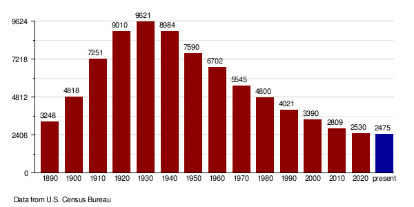
| Historical population | |||
|---|---|---|---|
| Census | Pop. | %± | |
| 1890 | 3,248 | — | |
| 1900 | 4,818 | 48.3% | |
| 1910 | 7,251 | 50.5% | |
| 1920 | 9,010 | 24.3% | |
| 1930 | 9,621 | 6.8% | |
| 1940 | 8,984 | −6.6% | |
| 1950 | 7,590 | −15.5% | |
| 1960 | 6,702 | −11.7% | |
| 1970 | 5,545 | −17.3% | |
| 1980 | 4,800 | −13.4% | |
| 1990 | 4,021 | −16.2% | |
| 2000 | 3,390 | −15.7% | |
| 2010 | 2,809 | −17.1% | |
| 2020 | 2,530 | −9.9% | |
| 2022 (est.) | 2,475 | −11.9% | |
| U.S. Decennial Census 1790-1960 1900-1990 1990-2000 2010-2020 |
|||
In 2020, the population of McIntosh County was 2,530 people.
According to the 2010 census, there were 2,809 people living in the county. Most people (98.1%) were white. About 76.8% of the people had German ancestry. Other common ancestries included Russian (26.9%) and Norwegian (6.2%).
Most people in McIntosh County speak English at home (74.22%). A large number also speak German at home (24.70%).
Population Changes Over Time
Towns and Communities
Cities
Township
- Roloff
See also
 In Spanish: Condado de McIntosh (Dakota del Norte) para niños
