Meall na h-Eilde facts for kids
Quick facts for kids Meall na h-Eilde |
|
|---|---|

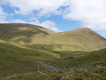
Seen from the head of Gleann Cia-aig, Two km to the south. The main summit to the left and the conical Meall an Tagraidh to the right.
|
|
| Highest point | |
| Elevation | 838 m (2,749 ft) |
| Prominence | 453 m (1,486 ft) |
| Listing | Corbett, Marilyn |
| Naming | |
| English translation | Hill Of The Hind |
| Language of name | Gaelic |
| Geography | |
| Location | Highland, Scotland |
| Parent range | Northwest Highlands |
| OS grid | NN185946 |
| Topo map | OS Landranger 34, OS Explorer 400 |
Meall na h-Eilde is a Scottish mountain. It is found in the Highland area of Scotland. The mountain is about 23 kilometers (14 miles) north of Fort William. It sits between two valleys, the Great Glen and Glen Garry.
Contents
About Meall na h-Eilde
Meall na h-Eilde stands 838 meters (2,749 feet) tall. This makes it a Corbett. Corbetts are Scottish mountains between 762 and 914 meters high. It is also a Marilyn, which is a hill with a drop of at least 150 meters on all sides.
The mountain was officially recognized as a Corbett in 1981. Before that, a nearby hill, Meall Coire nan Saobhaidh, was thought to be the Corbett. But new measurements showed Meall na h-Eilde was taller.
A Royal Hideout: History of Meall an Tagraidh
There is a smaller peak near Meall na h-Eilde called Meall an Tagraidh. This peak has an interesting history. In April 1746, Charles Edward Stuart, also known as Bonnie Prince Charlie, hid here. He was a fugitive after losing the Battle of Culloden.
The prince stayed on the hill for several days and nights. People from the Clan Cameron brought him food and drink. They gave him whisky, cheese, and bread.
The name "Meall na h-Eilde" comes from Scottish Gaelic. It means "Hill of the Hinds." Hinds are female deer. The mountain's eastern side has a steep, bowl-shaped valley called Coire an Tagraidh. This valley offered good shelter from strong western winds. It was a safe place for hinds to raise their young.
Mountain Features
Meall na h-Eilde has one main ridge that goes north. It stretches for about 1.5 kilometers (1 mile) towards Glen Garry. Along this ridge, you can see several small lakes. The ridge then reaches a flatter area called Gearr Leacann, which means "Short Steep Ridge." From there, it drops steeply into the Glen Garry forest.
Another wider ridge goes southwest for 1.5 kilometers. It leads to a point 681 meters high. Then it becomes narrow and steep, heading towards Gleann Tarsuinn.
Connecting Peaks
Meall na h-Eilde is connected to two other peaks by high passes.
- To the northwest is Meall Coire nan Saobhaidh. It is about 1 kilometer away. The pass connecting them is called Bealach Choire a’ Ghuirein, which means "The Pass of the Corrie of the Pimple." This pass is 722 meters high.
- To the southeast is Meall an Tagraidh, a pretty cone-shaped hill. They are linked by the Bealach an Easain, or "The Pass of the Little Waterfall." This pass is about 630 meters high.
An old, ruined iron fence runs along the top of the ridge. This fence used to mark the old parish boundary. It can be helpful for finding your way if the weather is bad.
Water Flow
Meall na h-Eilde sits on Scotland's main water divide. Water flowing from its southern slopes goes into the Great Glen. It then travels through Loch Lochy and Loch Linnhe to reach the west coast. Water from its northern slopes flows into the River Garry. This river also reaches the Great Glen at Loch Oich. From there, it flows east through Loch Ness to the sea at Inverness.
How to Climb Meall na h-Eilde
Hikers often climb Meall na h-Eilde along with another Corbett called Geal Charn. Geal Charn is about 4 kilometers (2.5 miles) to the west.
You can approach Meall na h-Eilde from the north (Glen Garry) or the south (eastern end of Loch Arkaig). The southern route is shorter and more popular.
Southern Route
The southern path starts at the car park near the Eas Chia-aig waterfall. You can find it at grid reference NN176888. From there, you follow a track north through the trees of Gleann Cia-aig. After about four kilometers, you reach open moorland. Here, the mountain comes fully into view. You will cross a footbridge. Then, it is a steep climb to the Bealach an Easain. From this pass, reaching the summit is easy.
Northern Route
The northern approach begins at Greenfield in Glen Garry (NH200005). You take a path southwest through the forest for three kilometers. This path leads to the Allt Coire nan Saobhaidh stream. From there, you can climb the northern ridge. This ridge goes straight to the summit cairn. The cairn is on the northern side of the old fence.
The mountain offers amazing, clear views of the surrounding area. This is because it rises high above the land around it.
 | Kyle Baker |
 | Joseph Yoakum |
 | Laura Wheeler Waring |
 | Henry Ossawa Tanner |

