Meredith (CDP), New Hampshire facts for kids
Quick facts for kids
Meredith, New Hampshire
|
|
|---|---|

Meredith, New Hampshire
|
|
| Country | United States |
| State | New Hampshire |
| County | Belknap |
| Town | Meredith |
| Area | |
| • Total | 4.22 sq mi (10.92 km2) |
| • Land | 2.92 sq mi (7.55 km2) |
| • Water | 1.30 sq mi (3.37 km2) |
| Elevation | 520 ft (160 m) |
| Population
(2020)
|
|
| • Total | 2,527 |
| • Density | 866.60/sq mi (334.59/km2) |
| Time zone | UTC-5 (Eastern (EST)) |
| • Summer (DST) | UTC-4 (EDT) |
| ZIP code |
03253
|
| Area code(s) | 603 |
| FIPS code | 33-47060 |
| GNIS feature ID | 2378081 |
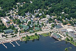
Meredith is a lovely community in Belknap County, New Hampshire, in the United States. It's like the main village within the larger town of Meredith. In 2020, about 2,527 people lived in this part of Meredith. The entire town of Meredith had a population of 6,662 people.
Contents
Exploring Meredith's Location
Meredith is located in a beautiful spot in New Hampshire. It sits between two large lakes. To the west, you'll find Lake Waukewan. To the east, there's Meredith Bay, which is part of the much larger Lake Winnipesaukee.
Roads and Nearby Towns
Several important roads meet in Meredith. U.S. Route 3 and New Hampshire Route 25 cross paths near Meredith Bay. These roads connect Meredith to other towns.
- Route 3 and Route 25 go north about 8 miles to Holderness.
- Route 3 goes south about 5 miles to Weirs Beach. It continues about 11 miles to the center of Laconia.
- Route 25 goes northeast about 5 miles to Center Harbor. It then goes about 9 miles to Moultonborough.
- New Hampshire Route 104 starts in Meredith and heads west. It leads to Interstate 93 in New Hampton, about 8 miles away.
- New Hampshire Route 106 also starts near Meredith. It offers a direct path to Laconia, about 10 miles south.
Size of Meredith
The area of Meredith that is considered the main village (called a census-designated place) covers about 4.2 square miles (10.9 square kilometers). A good portion of this area is water, thanks to the nearby lakes. About 1.3 square miles (3.4 square kilometers) of it is water.
People of Meredith
The number of people living in Meredith has changed over the years. Here's how the population has grown:
| Historical population | |||
|---|---|---|---|
| Census | Pop. | %± | |
| 1970 | 1,017 | — | |
| 1980 | 1,202 | 18.2% | |
| 1990 | 1,654 | 37.6% | |
| 2000 | 1,739 | 5.1% | |
| 2010 | 1,718 | −1.2% | |
| 2020 | 2,527 | 47.1% | |
| U.S. Decennial Census | |||
In 2010, there were 1,718 people living in the main village area. They lived in 740 households. Many of these households were families.
Who Lives in Meredith?
- About 19% of the people were under 18 years old.
- About 23% were 65 years old or older.
- The average age of people in Meredith was about 45.6 years old.
Most people living in Meredith are White. There are also small numbers of people from other backgrounds, including African American, Native American, and Asian people. Some residents are also of Hispanic or Latino heritage.
Households and Income
Many households in Meredith are made up of families, including married couples. Some households have children under 18. There are also many households where people live alone, especially those who are 65 or older.
The average yearly income for a household in Meredith was estimated to be about $42,880 between 2011 and 2015. For families, the average income was higher, around $70,278. Like many places, some people in Meredith live below the poverty line.
See also
 In Spanish: Meredith (condado de Belknap) para niños
 | James B. Knighten |
 | Azellia White |
 | Willa Brown |


