
Merryton Low facts for kids
Quick facts for kids Merryton Low |
|
|---|---|

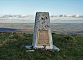
Trig point with WWII memorial plaque
|
|
| Highest point | |
| Elevation | 489 m (1,604 ft) |
| Prominence | 53.0 m (174 ft) |
| Parent peak | Shining Tor |
| Listing | TuMP (400-499m), Clem (Tu,4,Cm) |
| Geography | |

Merryton Low
Location in Staffordshire
|
|
| Location | Staffordshire, England |
| Parent range | Peak District |
| OS grid | SJ994737 |
| Topo map | OS (1:50k) 119 (1:25k) OL24W |
Merryton Low is a cool hill in Staffordshire, England. It's found a few miles east of a town called Leek. This hill is part of the Staffordshire Moorlands area. It's a great spot for exploring the outdoors!
Merryton Low is also part of the White Peak area. This beautiful region is inside the Peak District National Park. The park is a special place where nature is protected.
Contents
Exploring Merryton Low
How High Is It?
Merryton Low stands at 489 meters (about 1,604 feet) above sea level. This makes it a noticeable feature in the landscape. It's a fun challenge for hikers!
Its Place Among Hills
Merryton Low is connected to a larger hill called Shining Tor. Shining Tor is considered its "parent peak." This means Shining Tor is taller and Merryton Low is a smaller peak nearby. Merryton Low is ranked as the 6,366th highest peak in the British Isles. It is also the 729th tallest hill in England.
Ancient Burial Mounds
Merryton Low is home to two ancient bowl barrows. These are old burial mounds from a long time ago.
- One barrow, called Merryton Low bowl barrow, is right at the top of the hill.
- Another barrow is about 700 meters (about 2,300 feet) to the south.
Both of these barrows are protected as scheduled monuments. This means they are important historical sites.
The Trig Point and War Memorial
At the very top of Merryton Low, you'll find a trig point. A trig point is a special marker used by mapmakers to measure distances. This particular trig point is very important. It is a grade II listed structure.
Remembering Heroes
The trig point has a special plaque on it. This plaque remembers four members of the local Home Guard. The Home Guard was a group of volunteer soldiers during World War II. These four people later died while serving in the regular army. The plaque helps us remember their bravery and sacrifice.
World War II History
Merryton Low was also the site of two plane crashes during World War II.
- On July 13, 1942, a Short Stirling aircraft crashed here.
- On July 27, 1944, a Hawker Hurricane also crashed on the hill.
These events are part of the hill's history during the war.
The River Hamps
The River Hamps starts its journey on the southern slopes of Merryton Low. This river flows through the landscape, adding to the natural beauty of the area.
Images for kids
-
A trig point on Merryton Low, with a plaque remembering those who served in World War II.
