Middle Fork Feather River facts for kids
Quick facts for kids Middle Fork Feather River |
|
|---|---|

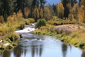
The Middle Fork at Blairsden Bridge, October 2011
|
|

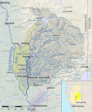
Map of the Feather River watershed including the Middle Fork Feather
|
|
| Other name(s) | El Rio de las Plumas |
| Country | United States |
| State | California |
| Region | Sierra Nevada |
| Cities | Beckwourth, Portola, Cromberg, Graeagle |
| Physical characteristics | |
| Main source | Near Beckwourth Sierra Valley, Plumas County 4,872 ft (1,485 m) 39°48′49″N 120°22′46″W / 39.81361°N 120.37944°W |
| River mouth | Lake Oroville About 10 miles (16 km) northeast of Oroville, Butte County 928 ft (283 m) 39°38′29″N 121°17′11″W / 39.64139°N 121.28639°W |
| Length | 98 mi (158 km), East-west |
| Basin features | |
| River system | Feather River watershed |
| Basin size | 1,062 sq mi (2,750 km2) |
| Tributaries |
|
The Middle Fork Feather River is a big river in California, a state in the United States. It flows through Plumas and Butte Counties. This river is almost 100 miles (160 km) long. It helps drain a large area of the rugged northern Sierra Nevada mountains.
Contents
Journey of the Middle Fork Feather River
The Middle Fork Feather River starts near Beckwourth. This area is in the Sierra Valley, which is the biggest mountain basin in the Sierra Nevada. Many small streams come together here. The largest of these is Little Last Chance Creek, which flows from Frenchman Lake.
River's Path Through Valleys and Canyons
As the river flows west, it meets Big Grizzly Creek. This creek brings water from Lake Davis. The Middle Fork Feather River then passes Portola. It turns northwest near Clio, where Sulphur Creek joins it.
Near Graeagle, Frazier Creek and Gray Eagle Creek add their waters. Frazier Creek comes from Gold Lake, and Gray Eagle Creek flows from Long Lake. After going through the Mohawk Valley, the river enters a deep canyon.
Tributaries and Rapids
Several other creeks join the river in the canyon. These include Jamison Creek, Nelson Creek, and Onion Valley Creek. Bear Creek, Willow Creek, and the North Fork Middle Fork Feather River also join. The river flows west-southwest through a narrow, steep canyon filled with fast-moving water and rapids.
Later, the South Branch Middle Fork Feather River joins from the left. The river then widens into an arm of Lake Oroville. This lake is a large reservoir created by the Oroville Dam. The Fall River also joins here.
Connection to the Feather River System
Lake Oroville is fed by four main parts of the Feather River: the North, Middle, West, and South Forks. These forks used to join together in the valley to form the main Feather River. The Feather River then flows south to meet the Sacramento River near Plumas Landing.
One of the Middle Fork Feather's smaller rivers, the Fall River, creates the amazing Feather Falls. This waterfall is 640-foot (200 m) tall. It is one of the tallest waterfalls in California.
A Special Wild and Scenic River
The United States government recognizes the Middle Fork Feather River for its natural beauty. A long part of the river, about 77.6 miles (124.9 km), is called a National Wild and Scenic River. This means it is protected for its wild and untamed nature.
A 32.9 miles (52.9 km) section of the river is hard to reach by roads. This part is famous for having some of the best wild trout fishing in California.
Grizzly Valley: A Key Area
The Grizzly Valley is an area of about 21 sq mi (54 km2) in the upper part of the Middle Fork Feather watershed. A watershed is the land area that drains water into a river. This valley gets a lot of rain and snow each year, between 29 and 37 inches.
Lake Davis is located in Grizzly Valley. This lake was created in 1967 by the Grizzly Valley Dam, which holds back the waters of Big Grizzly Creek.
 | William M. Jackson |
 | Juan E. Gilbert |
 | Neil deGrasse Tyson |

