
Middlesex facts for kids
| Middlesex | |
 |
|
| Geography | |
| Status | Ceremonial county (until 1965) Administrative county (1889–1965) |
| 1801/1881 area | 734 km2 (181,320 acres) |
| 1911 area | 601.8 km2 (148,701 acres) |
| 1961 area | 601.7 km2 (148,691 acres) |
| HQ | see text |
| Chapman code | MDX |
| History | |
| Origin | Middle Saxons |
| Created | Early Middle Ages |
Quick facts for kids Demography |
|
|---|---|
| 1801 population - 1801 density |
818,129 11 inhabitants per hectare (4.5/acre) |
| 1881 population - 1881 density |
2,920,485 40 inhabitants per hectare (16.1/acre) |
| 1911 population - 1911 density |
1,126,465 19 inhabitants per hectare (7.6/acre) |
| 1961 population - 1961 density |
2,234,543 37 inhabitants per hectare (15/acre) |
| Politics | |
| Governance | Middlesex Quarter Sessions (until 1889) Within the metropolis: Metropolitan Board of Works (1855–1889) Middlesex County Council (1889–1965) |
| Subdivisions | |
| Type | Hundreds (ancient) Districts (1835–1965) |
Middlesex (pronounced MID-əl-seks) is a historic county in southeast England. It's mostly within the big city area of London. You can find small parts of it in nearby counties too.
The county's borders mostly followed three rivers: the Thames in the south, the Lea to the east, and the Colne to the west. A line of hills formed its northern border with Hertfordshire.
Middlesex got its name from the "Middle Saxon people" who lived there long ago. The county was officially formed in the 800s or 900s. It stayed an administrative area until 1965. Middlesex was the second smallest historic county in England, only bigger than Rutland.
The City of London became its own self-governing area in the 1100s. The Sheriffs of London also had power in Middlesex. This caused some problems as London grew.
As London expanded, its buildings spread into the countryside of Middlesex. This made it hard to manage local government and services. In the 1700s and 1800s, many people lived in the southeast of the county. This included the East and West Ends of London.
In 1855, a group called the Metropolitan Board of Works took over some big projects. This was for the crowded southeast part of Middlesex, plus parts of Kent and Surrey. The Metropolitan Police also started in the 1800s.
In 1889, about 20% of Middlesex became part of the new County of London. The rest formed the administrative county of Middlesex. It was run by the Middlesex County Council. This council met at the Middlesex Guildhall in Westminster.
More towns grew as public transport improved. This led to the creation of Greater London in 1965. Almost all of historic Middlesex became part of Greater London. The remaining small parts joined nearby counties.
Contents
Understanding Middlesex's Past


How Middlesex Got Its Name
The county's story began with the settlement of the Middle Saxons. We don't know the exact size of their land. But it definitely included the area of the county today. It also covered much of Hertfordshire.
The Middle Saxons were probably part of the Kingdom of the East Saxons. But they might have been independent at some point. The name "Middlesex" means "territory of the Middle Saxons." It comes from Old English words.
The Saxons got their name from the seax, a type of knife they used. This knife appears in the emblems of Essex and Middlesex. Both counties have three seaxes on their shields.
The Tower Division's Special Role
The Tower division, also known as the Tower Hamlets, was a special area. It was in the southeast of Middlesex. Today, it's mostly the London Borough of Tower Hamlets.
This area was like a "county within a county." It had its own military leader, called the Lord-Lieutenant of the Tower Hamlets. This made it independent from the main Middlesex county.
Challenges as London Grew

By the 1800s, the East End of London had grown to the border with Essex. The Tower division area had over a million people. As railways were built, London's suburbs spread across Middlesex.
The Metropolitan Police started serving areas near London in 1829. By 1840, they covered the entire county. However, local government was still messy. Many different groups were in charge of public services.
In 1855, the Metropolitan Board of Works took over some big projects. This was for the crowded southeast, but it didn't include the City of London. Even with these changes, the system was called "in chaos."
Middlesex Changes in 1889
In 1889, a new law created the administrative County of London. About 30,000 acres of Middlesex became part of this new county. This area was "cut off" from Middlesex for most purposes.

The part of Middlesex that joined the County of London was divided into 18 new boroughs. These included places like Bethnal Green, Chelsea, Hackney, and Westminster.
The rest of Middlesex came under the Middlesex County Council. This council had control over the remaining area. Middlesex also got back the right to choose its own sheriff. It had lost this right centuries ago.
Because of more growth, all rural areas in Middlesex were gone by 1934. Many urban districts became municipal boroughs.
The Birth of Greater London
After 1889, London kept growing. The county became almost entirely covered by London's suburbs. The population density increased a lot. This was helped by new railway lines and industries.
Middlesex played a big role in World War II. It was bombed from the air. It also had important military bases, like RAF Uxbridge. These bases were key in the Battle of Britain.
After the war, the population in inner London and Middlesex started to drop. But the outer parts of Middlesex kept growing. By 1961, many towns had over 100,000 people. This meant they could become their own "county boroughs."
If this happened, Middlesex would lose more than half its population. So, a special group suggested getting rid of the county. This led to the London Government Act 1963. It came into effect on April 1, 1965.
This law ended the administrative counties of Middlesex and London. Almost all of historic Middlesex became part of Greater London. It formed many new outer London boroughs. These include Barnet, Brent, Ealing, and Enfield.
Some small parts of Middlesex went to other counties. Potters Bar Urban District joined Hertfordshire. Sunbury-on-Thames Urban District and Staines Urban District joined Surrey.
Where Was the County Town?

Middlesex never really had one main county town. The City of London was often seen as its county town for many things. For example, county trials were held at the Old Bailey in London.
From 1612 to 1782, the county's main court met at Hicks Hall in Clerkenwell. This was just outside the City of London.
New Brentford was sometimes called the county town in the late 1700s. This was because elections for Members of Parliament were held there. But it didn't have a town hall or other public buildings.
The Middlesex County Council later met at the Middlesex Guildhall in Westminster. However, this building was actually in the new County of London after 1889. So, it was outside the council's own area.
Middlesex's Landscape

Middlesex was in the London Basin. The most important feature was the River Thames, which formed its southern border. The River Lea and River Colne were natural borders to the east and west.
The county was mostly flat and low-lying. It had clay soil in the north and gravel in the south. Long ago, much of it was covered by the ancient Forest of Middlesex. In 1086, about 30% of Middlesex was woodland.
The highest point in Middlesex is the High Road near Bushey Heath, at 502 feet (153 meters).
Bentley Priory Nature Reserve has Middlesex's oldest tree, called The Master Oak. Its age is unknown, but it might have been a tiny acorn during King Henry VIII's time.
How Middlesex Grew Economically
People lived in the Middlesex area thousands of years before it became a county. Its economy relied on the City of London from early times. It was mainly a farming area.
Farmers grew crops like grain and hay for London. They also raised livestock and provided building materials. Tourism started in the late 1500s. People visited gardens and inns for day trips from London.
Hampton Court Palace opened to the public in the 1800s. In 1851, 350,000 people visited it.
By the 1700s, the inner parts of Middlesex became London's suburbs. They grew more and more urban. In 1794, Thomas Cox said that Middlesex was "almost all London." He noted that citizens filled its towns with their country houses.
The building of railways from 1839 changed things a lot. Instead of farming, large areas were used for building houses. Towns like Tottenham and Enfield grew as working-class suburbs. They had easy access to central London.
After World War I, new industries came to Middlesex. Places like Hayes became perfect for new factories. This was because of available workers and closeness to London. More jobs brought more people, and the population kept growing.
Middlesex also became a center for the film industry. Twickenham Studios started in 1913. Other studios were in places like Cricklewood and Southall.
Middlesex as a Postal County
Middlesex (often shortened to Middx) was once a postal county. Until 1996, counties were used in addresses to help sort mail. They helped avoid confusion between towns with similar names.
The postal county of Middlesex didn't exactly match the historic county's borders. This was because of the London postal district. This district stretched into Middlesex, including places like Tottenham and Chiswick. Addresses in these areas used "LONDON" as the post town.
When Greater London was created in 1965, Royal Mail kept Middlesex as a postal county. It would have been too expensive to change all the addresses. The postal county was actually two separate areas. One was around Enfield, and the other was a larger area to the west.
Culture and Community in Middlesex
Flag and Coat of Arms
The Middlesex Flag is officially recognized. It uses the design from the old Middlesex County Council's coat of arms. A similar design has been used in Middlesex and Essex for centuries.


The Anglo-Saxon kingdoms had their own symbols. The Kingdom of Essex, which included the Middle Saxon area, had three "seaxes" (short swords) on a red background. The word "Saxon" might even come from this knife.
These arms became linked to Middlesex and Essex. In 1910, Middlesex County Council added a "Saxon Crown" to its arms. This crown was inspired by an old coin of King Athelstan. The official grant of arms was made on November 7, 1910.
Military History
Middlesex had its own military units throughout history. These included the Middlesex Regiment and the Middlesex Yeomanry.
The special Tower Division in the southeast had its own military setup.
Middlesex Day Celebration
Middlesex Day is celebrated every year on May 16. This day remembers the brave actions of the 57th (West Middlesex) Regiment in 1811. This happened during the Battle of Albuera in the Peninsular War.
During the battle, Lieutenant-Colonel William Inglis was hurt. But he stayed with his regiment's flag. He encouraged his men by shouting, "Die hard 57th, die hard!" The regiment held its ground, and the battle was won.
The 'Die Hards' became the regiment's nickname. The phrase "Die Hard" also became a common saying.
County Flower
In 2002, a campaign asked people to vote for a flower to represent their county. The wood anemone was chosen for Middlesex. This flower was very common in the old Forest of Middlesex.
When London's suburbs grew, many of Middlesex's woods were saved. The wood anemone still blooms in these woods today.
Local History Groups
The London and Middlesex Archaeological Society (LAMAS) started in 1855. It studies the history and archaeology of London and Middlesex. It works closely with the Museum of London.
There are also groups for family historians in Middlesex. They help people research their family trees.
Middlesex in Literature
Sir John Betjeman, a famous poet, was born in Middlesex in 1906. He wrote many poems about Middlesex and suburban life. His TV readings Metroland featured many of these poems.
He wrote:
Dear Middlesex, dear vanished country friend,
Your neighbour, London, killed you in the end.
Sports in Middlesex
Middlesex is still used as a name for many sports groups.
Rugby Union
Several rugby union clubs play in Middlesex leagues. These include Harlequins and Saracens.
Middlesex Rugby is the main group for rugby in the county. It picks players for the Middlesex team. It also runs many cup competitions and leagues for clubs. The group also helps promote youth and women's rugby.
Football
The Middlesex County Football Association helps organize football in the county. It runs many cup competitions. The most important are the Middlesex Senior Cup and the Middlesex Senior Charity Cup.
The Middlesex County Football League started in 1984. It has five divisions for local teams.
Cricket

Middlesex County Cricket Club is one of the top cricket clubs in England. It started in 1864. Teams from Middlesex have played top-level cricket since the early 1700s. Middlesex has won the County Championship thirteen times.
The Middlesex Cricket Board manages all amateur cricket in the county. The Middlesex County Cricket League is the highest level for local club cricket.
Other Sports
Many other sports have Middlesex-based organizations:
- Middlesex Bowling Association has over 80 clubs.
- Middlesex County Amateur Swimming Association organizes swimming, diving, and water polo.
- Middlesex County Athletics Association controls amateur athletics.
- Middlesex Golf represents 33 golf clubs.
- Middlesex Tennis helps people play and compete in tennis.
- Middlesex County Badminton Association has over 80 clubs.
- Middlesex Squash & Racketball Association promotes squash.
- Middlesex County Archery Association is for archery.
- Middlesex Small-Bore Rifle Association organizes rifle and airgun clubs.
- Middlesex County Chess Association helps chess players.
- Middlesex County Bridge Association runs bridge competitions.

Images for kids
-
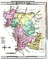
Map of Middlesex, 1824. Note: west is at the top.
-
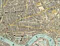
Map in 1882 shows complete urbanisation of the East End.
-
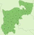
Middlesex urban districts in 1961.
-
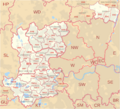
Middlesex former postal county.


See also
 In Spanish: Middlesex para niños
