Middletown, Maryland facts for kids
Quick facts for kids
Middletown, Maryland
|
|||||
|---|---|---|---|---|---|

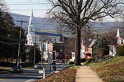
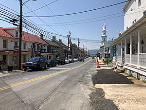
Main Street, Middletown
|
|||||
|
|||||

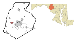
Location of Middletown, Maryland
|
|||||
| Country | |||||
| State | |||||
| County | Frederick | ||||
| Incorporated | 1833 | ||||
| Area | |||||
| • Total | 2.12 sq mi (5.49 km2) | ||||
| • Land | 2.12 sq mi (5.48 km2) | ||||
| • Water | 0.00 sq mi (0.01 km2) | ||||
| Elevation | 564 ft (172 m) | ||||
| Population
(2020)
|
|||||
| • Total | 4,943 | ||||
| • Density | 2,333.81/sq mi (901.24/km2) | ||||
| Time zone | UTC-5 (Eastern (EST)) | ||||
| • Summer (DST) | UTC-4 (EDT) | ||||
| ZIP code |
21769
|
||||
| Area code(s) | 301, 240 | ||||
| FIPS code | 24-52425 | ||||
| GNIS feature ID | 0585831 | ||||
Middletown is a town in Frederick County, Maryland, United States. It is located in the Middletown Valley. This valley stretches between the Catoctin Mountains to the east and South Mountain to the west. The town got its name because it is midway between these two mountain ranges. In 2020, about 4,943 people lived there.
| Top - 0-9 A B C D E F G H I J K L M N O P Q R S T U V W X Y Z |
History of Middletown
Early Explorers and Settlers
A young George Washington once explored the South Mountain area. He said the Middletown Valley was one of the most beautiful places he had ever seen. Later, in 1755, he traveled through the valley with General Braddock. They used an old Indian trail on their way to Fort Cumberland.
German and English settlers began arriving in the valley in the 1730s. One of these settlers was Michael Jesserong. He bought 50 acres of land for £66. He named his new property Middletown. In 1767, he sold the first lots there. This year is officially known as the town's founding date.
Growth and Development
Middletown grew as the National Pike was built through the town in 1806. This road helped Main Street spread to the west. In 1854, telegraph lines from Frederick to Hagerstown were set up through Middletown. Later, in 1896, the first electric car from the Frederick Middletown Railway arrived in town.
During the American Civil War, both Union and Confederate armies passed through Middletown. They were on their way to important battles like South Mountain and Antietam. After these battles, many wounded soldiers needed help. The people of Middletown opened their churches and homes to care for them.
Historic Buildings and Architecture
Middletown has many old buildings that show its history. The oldest part of town is along West Main Street and South Church Street. Here, you can see buildings with Federal and Greek Revival styles. Examples include the Zion Evangelical Lutheran Church (built 1859–1860) and Christ Reformed Church United Church of Christ (built 1818).
When the Hagerstown and Frederick Railway arrived in the 1890s, the town grew eastward. In this area, you can find buildings from the Victorian era. These include Queen Anne, Gothic Revival, and Colonial Revival styles. The town was very successful in the early 1900s. This led to new buildings and changes to older ones on Main Street. The Valley Savings Bank, for example, was built in the Beaux-Arts style. Many of these historic buildings are part of the Middletown Historic District.
Geography of Middletown
Middletown covers about 1.74 square miles (4.5 square kilometers) of land. There is almost no water area within the town limits. Catoctin Creek flows south about a mile west of town.
To the east of Middletown is Braddock Mountain. This mountain is named after the British general Edward Braddock. Some local stories say that a mythical creature called the Snallygaster lives on Braddock Mountain. This creature is described as a bird or dragon that takes livestock and people from the valley.
Transportation in Middletown
Most people travel to and from Middletown by road. Two main highways serve the town. U.S. Route 40 Alternate runs through Middletown as Main Street. It connects to Interstate 70 near Frederick to the east. To the west, it leads to Boonsboro.
Maryland Route 17 follows Church Street through the town. It goes north to I-70 at Myersville. Southward, it connects to U.S. Route 340 near Brunswick.
Population and People
| Historical population | |||
|---|---|---|---|
| Census | Pop. | %± | |
| 1870 | 746 | — | |
| 1880 | 705 | −5.5% | |
| 1890 | 667 | −5.4% | |
| 1900 | 665 | −0.3% | |
| 1910 | 692 | 4.1% | |
| 1920 | 749 | 8.2% | |
| 1930 | 818 | 9.2% | |
| 1940 | 839 | 2.6% | |
| 1950 | 936 | 11.6% | |
| 1960 | 1,036 | 10.7% | |
| 1970 | 1,262 | 21.8% | |
| 1980 | 1,748 | 38.5% | |
| 1990 | 1,834 | 4.9% | |
| 2000 | 2,668 | 45.5% | |
| 2010 | 4,136 | 55.0% | |
| 2020 | 4,943 | 19.5% | |
| U.S. Decennial Census | |||
Middletown's Population in 2010
In 2010, the town had 4,136 people living in 1,484 households. About 1,166 of these were families. The population density was about 2,377 people per square mile. Most of the people living in Middletown were White (91.9%). Other groups included African American (2.8%), Asian (2.8%), and Native American (0.3%). About 3.1% of the population was Hispanic or Latino.
Many households (45.3%) had children under 18 living with them. Most households (64.8%) were married couples. The average household had 2.79 people. The average family had 3.16 people. The median age in Middletown was 39.6 years old. About 29.9% of residents were under 18.
Famous People from Middletown
- Scott Devours – A drummer who has played with Roger Daltrey.
- Rick Leonard – A former National Football League player.
- Charlie “King Kong” Keller – A five-time Major League Baseball All-Star player.
- Hal Keller – A former Major League Baseball player and general manager for the Seattle Mariners.
- Amber Theoharis – A reporter for MASN/Baltimore Orioles and co-host on NFL Network.
- Lawrence Everhart – A veteran of the American Revolutionary War and a Maryland Pastor. He is known for rescuing Lieutenant Colonel William Washington at the Battle of Cowpens.
- Jason Freeny – A toy designer born in 1970.
See also
 In Spanish: Middletown (Maryland) para niños
 | May Edward Chinn |
 | Rebecca Cole |
 | Alexa Canady |
 | Dorothy Lavinia Brown |


