Mohali district facts for kids
Quick facts for kids
Mohali district
Sahibzada Ajit Singh Nagar district
|
|
|---|---|

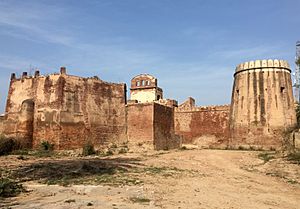
Manauli Fort
|
|

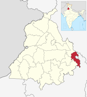
Location in Punjab
|
|
| Country | |
| State | Punjab |
| Established | 14 April 2006 |
| Headquarters | Mohali |
| Area | |
| • Total | 1,098 km2 (423.9402 sq mi) |
| Population
(2011)
|
|
| • Total | 994,628 |
| • Density | 905.9/km2 (2,346.1517/sq mi) |
| Languages | |
| • Official | Punjabi |
| Time zone | UTC+5:30 (IST) |
| ISO 3166 code | IN-PB-SA |
| Vehicle registration | PB 65 |
| Vidhan Sabha constituency | S.A.S. Nagar (Mohali) |
| Lok Sabha constituency | Anandpur Sahib |
Mohali district, also known as Sahibzada Ajit Singh Nagar district or SAS Nagar district, is a district in Punjab, a state in north-west India. It was created on April 14, 2006, making it the 18th district of Punjab.
This district was formed by taking parts from the Ropar and Patiala districts. It is located near the city of Chandigarh and the Panchkula district in Haryana. The district is named after Sahibzada Ajit Singh, who was the eldest son of Guru Gobind Singh.
Contents
History of Mohali
The area now known as Mohali was originally called Mohali or Mohyali. It was named after the Hindu Mohyal Brahmins who lived there.
How the District is Organized
The SAS Nagar district is divided into three main areas called tehsils. Each tehsil also works as a sub-division. These tehsils are Dera Bassi, Kharar, and SAS Nagar-Mohali.
The district also has four areas called community development blocks (CDBs or 'blocks'). These are Dera Bassi CDB, Kharar CDB, Majri CDB, and part of Rajpura CDB. There are fifteen towns in SAS Nagar district.
Dera Bassi Block
This block includes 144 villages and two towns: Zirakpur and Dera Bassi. Six villages in this block are not lived in. In 2001, the total population of this block was about 217,000 people. Most of these people (about 170,000) lived in rural areas.
Dera Bassi block has many small businesses. These include making chemical paints, steel tubes, plywood, and handlooms. These businesses provide many jobs. The soil in this area is mostly sandy. Zirakpur has grown very quickly and is now part of the larger Chandigarh area.
Kharar Block
The Kharar block has 154 villages and two towns: Ajitgarh and Kharar. Four villages here are not lived in. In 2001, the total population of this block was about 370,000 people. About 196,000 people lived in the rural areas.
SAS Nagar has become an important industrial area and the district headquarters. It is now like a smaller city connected to Chandigarh and has grown very fast.
Majri Block
Majri Block has 116 villages, with one village not lived in. This block is part of the Kharar sub-division. In 2001, the total population of this block was about 111,600 people. About 88,500 people lived in the rural areas.
Kurali is the only town in this block, with a population of about 23,000. Many large and small businesses have started around Kurali because the government has offered special help to them.
Important Buildings and Structures

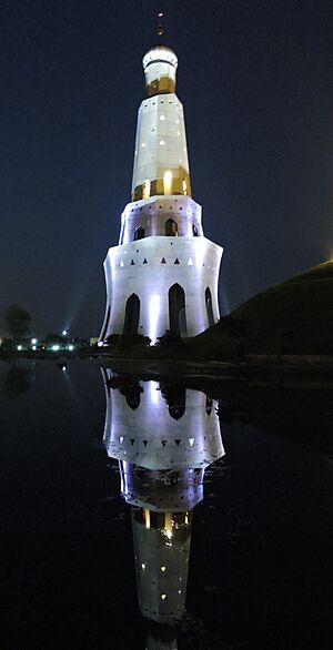
Fateh Burj: The Victory Tower
The Fateh Burj is the tallest victory tower in India. It stands about 328 feet (100 meters) tall. This tower was built to celebrate the start of Sikh rule in India in 1711.
It is also known as the Baba Banda Singh Bahadur War Memorial. This is the place where Banda Singh Bahadur, a respected Sikh warrior, won a very important battle against Wazir Khan, who was the commander of the Mughal army.
People and Languages
According to the 2011 census, SAS Nagar district has a population of about 994,600 people. This number is similar to the population of the country of Fiji. The district ranks 450th in India for population size.
The district has about 830 people living per square kilometer. Between 2001 and 2011, the population grew by about 32%. For every 1,000 males, there are 878 females. The ability to read and write, called the literacy rate, is about 84.9%.
| Religions in Shahibzada Ajit Singh Nagar district (2011) | ||||
|---|---|---|---|---|
| Religion | Percent | |||
| Sikhism | 48.15% | |||
| Hinduism | 47.88% | |||
| Islam | 2.96% | |||
| Christianity | 0.54% | |||
| Other or not stated | 0.46% | |||
In 2011, most people (about 94.7%) in the district spoke Punjabi as their first language. About 4.2% spoke Hindi.
Weather in Mohali
Mohali has a subtropical climate. This means summers are hot, and winters are cold because the district is close to the mountains in Himachal. The monsoon season brings mild to average rainfall.
In summer (May to September), temperatures can reach up to 47 degrees Celsius (117 degrees Fahrenheit). In winter (November to February), temperatures can drop as low as 0 or 1 degree Celsius (32 or 34 degrees Fahrenheit). During the monsoon months, the weather is hot and humid. Spring is pleasant with a slight chill in the air.
Politics and Government
The district has elected representatives who work in the government. For example, the MLA for the Dera Bassi area is Kuljit Singh Randhawa. He belongs to the Aam Aadmi Party.
Towns and Villages
Here are some of the towns and villages located within the Mohali district:
- Mullanpur
- Zirakpur
- New Chandigarh
- Kharar
- Bakarpur
- Bhankharpur
- Banur
- Chappar Chiri
- Cholta Kalan
- Daon
- Mubarik Pur
- Rampur Sanian
- Sohana
- Baironpur
- Kurali
- Kumbhra
- Dera Bassi
- Mattaur
- Tewar (Tiaur)
- Nayagaon
- Lalru
- Jhande Majra
- Dappar
- Machhli Kalan
See also
 In Spanish: Distrito de Sahibzada Ajit Singh Nagar para niños
- Sahibzada Ajit Singh Nagar Assembly Constituency
 | James Van Der Zee |
 | Alma Thomas |
 | Ellis Wilson |
 | Margaret Taylor-Burroughs |

