Mole Creek facts for kids
Quick facts for kids Mole CreekTasmania |
|||||||||
|---|---|---|---|---|---|---|---|---|---|

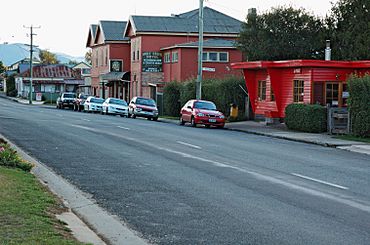
Mole Creek Hotel and post office.
|
|||||||||
| Population | 609 (2011 census) | ||||||||
| Postcode(s) | 7304 | ||||||||
| Elevation | 240 m (787 ft) | ||||||||
| Location |
|
||||||||
| LGA(s) | Meander Valley Council | ||||||||
| State electorate(s) | Lyons | ||||||||
| Federal Division(s) | Lyons | ||||||||
|
|||||||||
Mole Creek is a small town in central northern Tasmania, Australia. It's located in the upper Mersey Valley. Mole Creek is famous for its delicious honey! In fact, about 35% of all honey made in Tasmania comes from this area.
The town is mostly within the Meander Valley Council area. A small part of it is also in the Kentish Council area.
Contents
History of Mole Creek
Early Aboriginal History
Aboriginal people have lived on the island of Tasmania for thousands of years. The earliest signs of people living here date back at least 35,000 years. Before Europeans arrived, the land around Mole Creek belonged to the Pallittorre Aboriginal tribe.
They lived in a wide area, including Deloraine and the Gog mountain range. The Pallittorre people even mined ochre (a natural earth pigment) in the Toolumbunner pits. Evidence shows they lived in the Mole Creek area for at least 10,000 years.
European Settlement and Growth
In the 1820s, the Van Diemen's Land Company created a path for livestock from Deloraine to Emu Bay (now Burnie). This path went through Chudleigh and Mole Creek. Before this, cattle farmers had already used the land west of Westbury.
The name "Mole Creek" comes from a nearby stream. This creek flows above ground, then disappears into underground caves, and then reappears. The caves have been attracting tourists since the 1850s. This led to the building of places for visitors to stay in Mole Creek.
By 1876, the town had mills powered by water to grind flour and cut timber. A post office opened in 1884. Later, lime kilns were built to use the large amounts of limestone found in the area.
Mole Creek in the 20th Century
In the early 1900s, more caves were opened for tourism, which helped the town grow. King Solomon's Cave was found in 1906 and opened for tours in 1908. Marakoopa Cave was discovered in 1910 and opened in 1912.
The building that is now the Mole Creek Hotel was built in 1907-1908. It started as a large guest house with 30 rooms. It became a hotel that could serve alcohol in 1953.
Honey Production
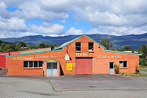
Robert Stephens started a commercial honey business in Mole Creek in 1918. By 1923, his factory had 50 beehives. They sold honey under the "Golden Bee" brand.
Since 1951, the factory has focused on leatherwood honey. Each year, beehives are moved to Tasmania's west coast. This is where the unique leatherwood flowers grow, giving the honey its special taste. The factory is still run by Stephen's family today.
It produces about 350 tonnes (390 tons) of honey each year. This makes up about 35% of all Tasmanian honey.
Modern Services
Electricity came to Mole Creek in 1936. A memorial hall was built in the early 1950s. A bush nursing centre, which is now a health centre, opened in 1944.
Railway History
A railway line opened in 1890. It ran for 20.4 kilometres (12.7 mi) from a junction near Deloraine to Mole Creek. The railway mostly carried timber to a paper mill in Burnie. Later, it also carried woodchips.
From the 1920s, passenger services were mostly run by small railcars. The line was closed in 1985, and the tracks were removed in 1992.
Churches in Mole Creek
The first church in Mole Creek was a Methodist (Wesleyan) chapel, built in 1878. It was also used as a school for some time. In 1976, it became part of the Uniting Church in Australia.
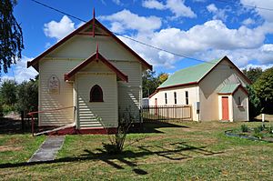
Other churches were also built over time. St Colombia's Anglican church was built in 1902 but closed in the early 1990s. Today, Mole Creek's only remaining church is St Andrew's Presbyterian Church, which opened in 1932 and is still in use.
Geography and Climate
Mole Creek is located about 240 metres (790 ft) above sea level. The area is known for its karst landscape. This means it has limestone rock with underground streams, sinkholes, and many caves. This landscape formed about 500 million years ago when the area was covered by a shallow sea.
There are over 400 caves and sinkholes in the Mole Creek area. Some of these, like King Solomon's Cave and Marakoopa Cave, are open to the public. These caves and other parts of the karst area became part of the Mole Creek Karst National Park in 1996.
The land around Mole Creek is mostly used for grazing animals. The area has a cool temperate climate. Winters can be very frosty, and it sometimes snows. The average rainfall is about 1,125 millimetres (44.3 in) per year.
| Climate data for Deloraine (Station 091000 temperature), Mole Creek (Station 091065 rainfall) | |||||||||||||
|---|---|---|---|---|---|---|---|---|---|---|---|---|---|
| Month | Jan | Feb | Mar | Apr | May | Jun | Jul | Aug | Sep | Oct | Nov | Dec | Year |
| Mean daily maximum °C (°F) | 21.3 (70.3) |
22.5 (72.5) |
19.6 (67.3) |
16.5 (61.7) |
13.2 (55.8) |
10.9 (51.6) |
10.4 (50.7) |
11.4 (52.5) |
13.3 (55.9) |
15.5 (59.9) |
17.7 (63.9) |
20.1 (68.2) |
16.1 (61.0) |
| Mean daily minimum °C (°F) | 7.7 (45.9) |
8.7 (47.7) |
6.3 (43.3) |
4.5 (40.1) |
2.7 (36.9) |
1.0 (33.8) |
0.9 (33.6) |
1.2 (34.2) |
3.1 (37.6) |
4.4 (39.9) |
5.4 (41.7) |
7.2 (45.0) |
4.4 (39.9) |
| Average rainfall mm (inches) | 52.9 (2.08) |
59.7 (2.35) |
60.6 (2.39) |
83.6 (3.29) |
109.5 (4.31) |
113.9 (4.48) |
147.6 (5.81) |
145.6 (5.73) |
113.1 (4.45) |
93.3 (3.67) |
72.1 (2.84) |
68 (2.7) |
1,125.1 (44.30) |
| Source 1: Bureau of Meteorology, Deloraine (Athol). | |||||||||||||
| Source 2: Bureau of Meteorology, Mole Creek. | |||||||||||||
Education
Mole Creek Primary School is a government school for students from kindergarten to grade 6. In 2015, it had 76 students. There has been a state school in Mole Creek since at least 1900.
Some of the school buildings were moved from other nearby towns. For example, a school building from Caveside was moved to Mole Creek in 1938. The primary school serves students from surrounding areas like Chudleigh and Caveside. The closest high school is in Deloraine.
Life in Mole Creek Today
Mole Creek is named after the creek that flows above and below ground through the area's cave system. The main industries here are forestry, farming, limestone mining, and the R Stephen's honey factory. One of the biggest employers is Unimim Lime Limited, which quarries and processes limestone.
The town is well-known for its honey, especially Leatherwood honey. This special type of honey is unique to Tasmania and is sold all over the world.
Things to See and Do
- Mole Creek Karst National Park: This park is home to the famous Marakoopa Cave and King Solomons Cave. These caves have been popular with tourists for over 100 years.
- Trowunna Wildlife Park: This is a 65-acre (26 ha) private sanctuary nearby. It has native Australian animals, some in enclosures and some roaming freely. The park helps protect Tasmanian devils by keeping a population free of facial tumour disease. It's also a training center for animal handling. You can see animals like quolls, wombats, kangaroos, and many types of birds here.
Community and Services
Mole Creek has a volunteer fire brigade. The town also has a cricket club and an Australian rules football club. There is a community-maintained swimming pool.
The town has a hotel, a guest house, a supermarket, a service station, and a post office. Mole Creek's cemetery opened in 1916 and is still in use.
Mole Creek is part of the Meander Valley Council local government area. At the 2011 census, the wider Mole Creek area had a population of 609 people.


