Monroe County, Iowa facts for kids
Quick facts for kids
Monroe County
|
|
|---|---|

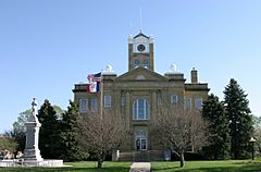
The courthouse in Albia is on the NRHP
|
|

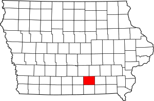
Location within the U.S. state of Iowa
|
|
 Iowa's location within the U.S. |
|
| Country | |
| State | |
| Founded | 1843 |
| Seat | Albia |
| Largest city | Albia |
| Area | |
| • Total | 434 sq mi (1,120 km2) |
| • Land | 434 sq mi (1,120 km2) |
| • Water | 0.6 sq mi (2 km2) 0.1% |
| Population
(2020)
|
|
| • Total | 7,577 |
| • Estimate
(2023)
|
7,504 |
| • Density | 17.459/sq mi (6.741/km2) |
| Time zone | UTC−6 (Central) |
| • Summer (DST) | UTC−5 (CDT) |
| Congressional district | 3rd |
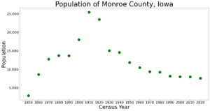
Monroe County is a county in the south central part of Iowa. Long ago, in the early 1900s, it was a big center for bituminous coal mining. In 1910, over 25,000 people lived here.
But as mining slowed down, many people moved away to find other jobs. In 2020, about 7,577 people lived in Monroe County. The main town, or county seat, is Albia. The county was first named Kishkekosh County. This was after a famous chief of the Meskwaki people. Later, it was renamed to honor James Monroe, who was the fifth President of the United States.
Contents
About Monroe County
Monroe County covers about 434 square miles. Most of this area is land. Only a tiny bit, about 0.6 square miles, is water.
Main Roads
You can travel through Monroe County on a few important roads:
Neighboring Counties
Monroe County shares its borders with five other counties:
- Marion County to the northwest
- Mahaska County to the northeast
- Wapello County to the east
- Appanoose County to the south
- Lucas County to the west
Population Changes
The number of people living in Monroe County has changed a lot over the years.
| Historical population | |||
|---|---|---|---|
| Census | Pop. | %± | |
| 1850 | 2,884 | — | |
| 1860 | 8,612 | 198.6% | |
| 1870 | 12,724 | 47.7% | |
| 1880 | 13,719 | 7.8% | |
| 1890 | 13,666 | −0.4% | |
| 1900 | 17,985 | 31.6% | |
| 1910 | 25,429 | 41.4% | |
| 1920 | 23,467 | −7.7% | |
| 1930 | 15,010 | −36.0% | |
| 1940 | 14,553 | −3.0% | |
| 1950 | 11,814 | −18.8% | |
| 1960 | 10,463 | −11.4% | |
| 1970 | 9,357 | −10.6% | |
| 1980 | 9,209 | −1.6% | |
| 1990 | 8,114 | −11.9% | |
| 2000 | 8,016 | −1.2% | |
| 2010 | 7,970 | −0.6% | |
| 2020 | 7,577 | −4.9% | |
| 2023 (est.) | 7,504 | −5.8% | |
| U.S. Decennial Census 1790-1960 1900-1990 1990-2000 2010-2018 |
|||
Recent Population Counts
In 2020, the census counted 7,577 people in Monroe County. Most people, about 93.81%, were non-Hispanic White. About 1.54% were Hispanic. Other groups made up smaller parts of the population. There were 3,636 homes, and 3,116 of them had people living in them.
In 2010, the population was a bit higher, with 7,970 people.
Towns and Communities
Monroe County has several towns and communities.
Cities
Small Communities
A Ghost Town
- Buxton was once a very important town. In the early 1900s, it was the largest town in the area where most people were Black. Now, it is a ghost town, meaning no one lives there anymore.
The largest city in Monroe County is Albia, with 3,721 people in 2020.
See also
 In Spanish: Condado de Monroe (Iowa) para niños
 | Emma Amos |
 | Edward Mitchell Bannister |
 | Larry D. Alexander |
 | Ernie Barnes |


