
Montanaire facts for kids
Quick facts for kids
Montanaire
|
||
|---|---|---|

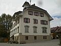
Saint-Cierges village school
|
||
|
||

Montanaire
Location in Switzerland

Montanaire
Location in Canton of Vaud
|
||
| Country | Switzerland | |
| Canton | Vaud | |
| District | Gros-de-Vaud | |
| Area | ||
| • Total | 33.5 km2 (12.9 sq mi) | |
| Population
(Dec 2020 )
|
||
| • Total | 2,777 | |
| • Density | 82.90/km2 (214.7/sq mi) | |
| Postal code |
1063 / 1064 / 1409 / 1410 / 1515
|
|
| Surrounded by | Boulens, Moudon, Sottens | |

Montanaire is a town in Switzerland, located in the canton of Vaud. It is part of the Gros-de-Vaud area.
This town was formed on January 1, 2013. It was created by joining nine smaller towns. These towns were Chapelle-sur-Moudon, Correvon, Denezy, Martherenges, Neyruz-sur-Moudon, Peyres-Possens, Saint-Cierges, Thierrens, and Chanéaz.
Contents
History of Montanaire's Villages
The different villages that now make up Montanaire have long histories. Here is a quick look at when some of them were first mentioned in old records:
Chapelle-sur-Moudon's Past
Chapelle-sur-Moudon was first written about in 1177 as Capellam. Later, in 1228, it was called Capella Vualdana. When the area was ruled by Bern, it was known as Chapelle Vaudanne. After the Vaud region was created in 1798, it was called Chapelle (VD) until 1953.
Other Villages' Beginnings
- Correvon was first mentioned in 1166 as Correuont.
- Denezy was first mentioned very early, in 929, as villare Donaciaco. In 1142, it was called Danisei.
- Martherenges first appeared in records in the 1400s as Martherenges.
- Neyruz-sur-Moudon was first mentioned in 1147 as Noeruls or Nuruls. It got its full name, Neyruz-sur-Moudon, in 1953.
- Peyres was first mentioned in 1200 as Pairi. Possens was mentioned in 1230 as Pussens.
- Saint-Cierges was first mentioned around 1145-54 as de sancto Sergio. In 1166, it was called de sancto Ciriaco.
- Thierrens was first mentioned around 1004-07 as Teoderinco.
- Chanéaz was first mentioned in 1184 as Chafneya.
Geography of Montanaire


The towns that formed Montanaire cover a total area of about 33.48 square kilometers (12.93 square miles). Most of these towns were from the Gros-de-Vaud District. Only Chanéaz was from the Jura-Nord Vaudois District.
Land Use in the Villages
Each former town has its own unique landscape:
- Chapelle-sur-Moudon: As of 2009, about 81.4% of its land is used for farming. About 13% is covered by forests. The rest, about 6.5%, has buildings or roads. This village is on the left side of the Broye valley and includes a small settlement called Combe.
- Correvon: As of 2009, about 83% of its land is for farming, and 12.5% is forest. Only 2.2% has buildings or roads. It sits on a flat area between the Broye and Mentue rivers.
- Denezy: As of 2009, about 72% of its land is for farming, and 23.2% is forest. About 5.3% has buildings or roads. This village is on the main road between Lausanne and Estavayer.
- Martherenges: As of 2009, this small area has about 60.2% farmland and 34.9% forest. About 4.8% is built up. It is on a hill next to the Broye valley.
- Neyruz-sur-Moudon: As of 2009, about 69.9% is farmland, and 26.4% is forest. About 3.4% has buildings or roads. This village is known as a haufendorf village, which means it grew in an unplanned way around a central area. It is located along the road from Moudon to Yverdon-les-Bains.
- Peyres-Possens: As of 2009, about 49% is farmland, and 39.6% is forest. About 9.9% has buildings or roads. This area is on a hilly plateau near the Mentue river and includes the villages of Peyres and Possens.
- Saint-Cierges: As of 2009, about 61.2% is farmland, and 33.9% is forest. About 4.8% has buildings or roads. It is on a flat area between the Broye and Mentue rivers. It includes the village of Saint-Cierges and small settlements like Corrençon.
- Thierrens: As of 2009, about 71.1% is farmland, and 22.6% is forest. About 6.5% has buildings or roads. This village is at an important crossroads for roads connecting Moudon, Yverdon, Echallens, and Payerne.
- Chanéaz: As of 2009, about 72.7% is farmland, and 25.9% is forest. About 2.9% has buildings or roads. This area is in the northern part of the Jorat plateau.
Population in Montanaire
The total population of Montanaire is 2,324 people, as of 2011.
Special Places in Montanaire
The entire village of Denezy is a very special place. It is listed as part of the Inventory of Swiss Heritage Sites. This means it has important historical and cultural value.
Weather in Montanaire
Thierrens, a part of Montanaire, usually has about 126.5 days of rain or snow each year. On average, it gets about 1,094 millimeters (43 inches) of rain or snow annually.
The wettest month is June, with about 111 millimeters (4.4 inches) of rain or snow over 11.3 days. May has the most days with precipitation, averaging 13.2 days, but with slightly less rain or snow (102 millimeters or 4 inches). The driest month is February, with about 76 millimeters (3 inches) of precipitation over 10.2 days.
Images for kids
-
Saint-Cierges village school
See also
 In Spanish: Montanaire para niños
