Montclair, Oakland, California facts for kids
Quick facts for kids
Montclair
|
|
|---|---|

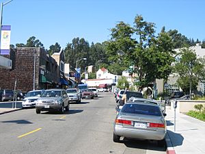
A street view of Montclair Village
|
|

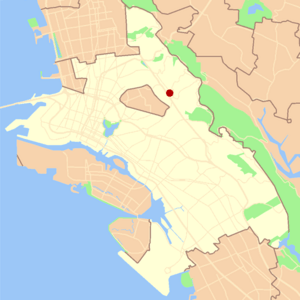
Location in Oakland
|
|
| Country | United States |
| State | California |
| County | Alameda |
| City | Oakland |
Montclair is a lovely hillside neighborhood in Oakland, California. It is also known as the Montclair District or Montclair Village. This area sits on the western side of the Oakland Hills. It stretches from a valley created by the Hayward Fault up to the top of the hills.
There are no exact borders for Montclair. However, people generally agree on its boundaries. Highway 24 is to the north, and Joaquin Miller Road is to the south. The city of Piedmont is to the west. The border of Contra Costa County is to the east. The heart of the neighborhood is a busy shopping area called Montclair Village. It is located near Highway 13 in the valley. Montclair is about 640 feet (195 meters) above sea level.
Contents
Exploring Montclair's Geography
The Montclair area is built around the Hayward Fault. This fault creates a valley that runs mostly from northwest to southeast. The land in Montclair rises slightly to the west and then climbs higher to the east, reaching the top of the Oakland hills.
Before modern buildings, Montclair was shaped by two creek valleys. One was in the northeast, and the other in the southwest. Both of these valleys run mostly from east to west. They flow from the Oakland Hills down to the valley formed by the Hayward Fault and beyond.
Creeks and Waterways
In the northwest, the upper parts of Temescal Creek flow down Thornhill Drive and Pinehaven Road. You can still see parts of this creek above ground in the higher areas. The creek has two branches that meet where Thornhill and Pinehaven cross. From there, the creek flows down the south side of Thornhill. It goes underground near Thornhill Elementary School. Then it flows down the rest of Thornhill and Mountain Blvd. to Broadway Terrace. Finally, it drains into Lake Temescal.
On the southeast side of Montclair, the north fork of Sausal Creek (also called Shephard Creek) flows down Shepherd Canyon. Near Highway 13, by the Montclair Golf Course parking lot, this north fork joins the south fork. The south fork is also known as Palo Seco Creek and comes from the eastern hills, including Joaquin Miller Park. After they join, the creek flows through Dimond Canyon. It then crosses the flatlands, mostly through underground pipes, before reaching San Francisco Bay.
Montclair's Past: A Look Back
Before the Spanish missions arrived, native Huchiun and Jalquin tribes lived in this area. These tribes were part of the Ohlone people.
In 1820, a large piece of land was given to Luis Maria Peralta. This land stretched from El Cerrito to San Leandro and included Montclair and Dimond Canyon. In 1842, Peralta divided his land among his sons. The San Antonio section, which had Montclair and Dimond Canyon, went to his son Antonio Maria Peralta.
Logging and Redwoods
Thornhill Road in the northern creek valley is one of Montclair's oldest roads. It was an old logging road from the 1800s. Hiram Thorn built it and named it after himself. Thorn's road was used to bring redwood logs to Oakland. These logs came from a huge forest called the Moraga Redwoods. He had a lumber mill near Pinehurst Road. Thornhill later became a toll road that went to Contra Costa County.
From Shepherd Canyon towards the southeast, the hills by the bay were covered in a huge redwood forest. This was known as the San Antonio Redwoods. Two very tall trees, called the Navigation or Blossom Rock trees, helped sailors. They used these trees as a guide to avoid Blossom Rock near Yerba Buena Island. Around 1847, settlers started cutting down trees in the San Antonio redwood forest. In 1850, the first steam sawmill in the area was built. It was on the edge of Montclair at Palo Seco Creek in Dimond Canyon. A logging road was built high along the north side of Dimond Canyon. This road later became Park Boulevard. It connected to a dock at 13th Avenue. Logs were transported down Dimond Canyon to the Bay. By 1860, the San Antonio forest was completely cut down.
A second logging period happened after the 1906 San Francisco earthquake. During this time, younger redwoods, about 50 years old, were cut. Even the stumps from the first logging were removed. One of the biggest redwood stumps ever found, 32 feet wide, is in the Oakland hills. Only one very old redwood, called the Grandfather, remains. Today, newer redwood trees are protected in parks. These include Reinhardt Redwood Regional Park, Joaquin Miller Park, and Roberts Regional Recreation Area. Redwoods of different ages can be found in many Montclair neighborhoods.
After the first logging, Caspar Hopkins started the Sausal Creek Water Company. He built a dam and a reservoir at the top of Dimond Canyon. This reservoir later became part of the East Bay Water Company. It was used until the early 1920s. Old maps show a road passing the reservoir. This road is now Waterhouse Road. It also extended up towards the dam along what is now the Upper Dimond Canyon Trail. In 1867, Hugh Dimond bought the canyon.
Railroads and Roads
In the early 1900s, the main line of the Sacramento Northern Railroad ran through Montclair. The tracks came from Lake Temescal. They crossed into Montclair over a bridge at Moraga Ave. and Thornhill Dr. Today, there is a small park there to remember this crossing. The tracks then ran along a high raised path between Montclair Recreation Center and Montclair Elementary School. They crossed Mountain Blvd. and Snake Road on another bridge. Then they continued up Shepherd Canyon to a tunnel. The west entrance of this tunnel was just below Saroni Drive.
Today, much of the old railroad path above the village and in Shepherd Canyon is a walking and biking trail. All the old railroad bridges in Montclair were removed many years ago. However, a new pedestrian bridge was built recently in the same spot as one of them. This bridge crosses Snake Road. It connects the two main parts of the walking path. The pathway was also paved at the same time.
In 1956, the State of California planned to build a freeway through Shepherd Canyon. This freeway would connect to a proposed bridge across San Francisco Bay. It would also go through a tunnel to Moraga and then north towards Pleasant Hill. This plan was dropped by the late 1960s.
Schools and Buildings
One of the first schools in Montclair was located where the old Moraga Avenue firehouse now stands. It was named after John Coffee Hays, who helped found the city of Oakland. The Hays school closed in 1913.
Even though few people lived here after the logging days, many homes were built in the village and hills starting in the 1920s.
The Montclair firehouse, built in 1927, was designed in a special style. It looked like a "Hansel and Gretel" storybook house. Eldred E. Edwards of the Oakland Public Works Department designed it. After the 1989 Loma Prieta earthquake, the Oakland Fire Department built a new station. This new station is on Shepherd Canyon Road. Once it was finished, the 1927 building was no longer used by the fire department.
In March 1930, the Montclair branch of the Oakland Public Library opened. It was on Mountain Blvd. near Thornhill Dr. It was built to serve the growing community. The small building had a similar English cottage-style design as the firehouse. It is still used as a library today. After 1965, new parts were added for the children's room and a patio at the back of the building.
Many homes on the northwestern edge of Montclair were destroyed in the Oakland firestorm of 1991.
Parks and Green Spaces
Montclair has many parks and green areas. Some are right in the district, and others are very close by. They offer great places for outdoor activities and enjoying nature.
- Beaconsfield Canyon
- Blair Park
- Dimond Canyon Park
- Huckleberry Botanic Regional Preserve
- Joaquin Miller Park
- Lake Temescal Regional Recreation Area
- Marjorie Saunders Park
- Montclair Railroad Trail
- Montclair Recreation Center
- North Oakland Regional Sports Center
- Dr. Aurelia Reinhardt Redwood Regional Park
- Robert Sibley Volcanic Regional Preserve
- Roberts Regional Recreation Area
- Shepherd Canyon Park
- Short Line Pocket Park
Community Groups in Montclair
Many groups in Montclair help make the community a better place. They work on different projects, from protecting nature to helping local businesses.
- Friends of Moraga Canyon – This group works to stop the building of a sports complex in Moraga Canyon. This canyon is in the nearby city of Piedmont.
- Montclair Neighborhood Council – This is a group of volunteers. They connect with residents, other groups, police, and city officials. Their goal is to help solve community problems.
- Montclair Tennis Association – This group organizes tennis events. They use the Montclair and other nearby public tennis courts.
- Montclair Village Association – This group helps more than 200 businesses in or near Montclair Village. They work to improve the business area.
- Piedmont Pines Neighborhood Association – This is one of Oakland's oldest homeowner's associations. They want to make Piedmont Pines a beautiful, safe, and diverse community.
Famous People from Montclair
Montclair has been home to several well-known people.
- Dave Brubeck, a famous jazz pianist and composer
- Jerry Brown, a politician who served as Governor of California
- Robert Greenberg, a composer, pianist, author, and music historian
- Joyce Maynard, an author
- Delroy Lindo, an actor
 | Kyle Baker |
 | Joseph Yoakum |
 | Laura Wheeler Waring |
 | Henry Ossawa Tanner |


