Monument Peak (Washington) facts for kids
Quick facts for kids Monument Peak |
|
|---|---|

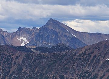
Monument Peak seen from Slate Peak
|
|
| Highest point | |
| Elevation | 8,597 ft (2,620 m) NAVD 88 |
| Prominence | 1,072 ft (327 m) |
| Listing | List of Highest Mountain Peaks in Washington |
| Geography | |
| Location |
|
| Parent range | Okanogan Range North Cascades Cascade Range |
| Topo map | USGS Mount Lago |
| Climbing | |
| First ascent | 1978 by Fred Beckey and John Roper |
| Easiest route | Scrambling class 3 |
Monument Peak is a tall mountain in Washington state. It stands 8,597-foot (2,620-metre) high! This peak is in Okanogan County, which is in the western part of Washington. It's part of the Okanagan Range, a smaller mountain group within the larger North Cascades.
You can find Monument Peak inside the Pasayten Wilderness. This area is managed by the Okanogan National Forest. The closest taller mountain is Mount Lago, about 2.42 miles (3.89 km) away to the north. Water from Monument Peak flows into Monument Creek and Eureka Creek. Both of these creeks eventually join the Methow River.
Contents
Understanding the Climate Around Monument Peak
How Weather Forms in the Cascades
Most weather systems start over the Pacific Ocean. They then travel northeast towards the Cascade Mountains. When these weather systems reach the North Cascades, the tall peaks force the air upwards.
Rain and Snow in the Mountains
As the air rises, it cools down. This causes it to drop its moisture as rain or snow onto the Cascades. This process is called Orographic lift. Because of this, the western side of the North Cascades gets a lot of rain and snow. This is especially true during the winter months.
Summer vs. Winter Weather
In winter, the weather is usually cloudy. But in summer, high-pressure systems over the Pacific Ocean become stronger. This often leads to clear skies with little or no cloud cover.
Exploring the Geology of Monument Peak
The Rugged Landscape of the North Cascades
The North Cascades area has very rugged land. You can see sharp peaks, tall spires, long ridges, and deep valleys carved by glaciers. These amazing shapes were created by geological events that happened millions of years ago. These events also caused big changes in height across the Cascade Range. This led to the different climates we see today.

How the Cascade Mountains Were Formed
The Cascade Mountains began forming millions of years ago. This was during a time called the late Eocene Epoch. The North American Plate was slowly moving over the Pacific Plate. This movement caused many volcanic eruptions.
Also, small pieces of the Earth's crust, called terranes, came together. These pieces were from both the ocean floor and continents. They helped create the North Cascades about 50 million years ago.
The Role of Glaciers and Earth Movements
During the Pleistocene period, which was over two million years ago, glaciers moved across the land many times. As they advanced and retreated, they scraped the landscape. They left behind piles of rock and debris.
The river valleys in this area have a "U" shape. This shape is a direct result of these recent glaciers. The rising of the land (called uplift) and cracks in the Earth (called faulting) worked with the glaciers. Together, these forces created the tall peaks and deep valleys you see in the North Cascades today.
 | Tommie Smith |
 | Simone Manuel |
 | Shani Davis |
 | Simone Biles |
 | Alice Coachman |


