Morrone facts for kids
Quick facts for kids Morrone |
|
|---|---|

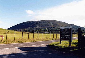
Morrone seen from Braemar Castle.
|
|
| Highest point | |
| Elevation | 859 m (2,818 ft) |
| Prominence | 155 m (509 ft) |
| Listing | Corbett, Marilyn |
| Naming | |
| English translation | Big Hill or Big Nose |
| Language of name | Gaelic |
| Geography | |
| Location | Aberdeenshire, Scotland |
| Parent range | Grampians |
| OS grid | NO131886 |
| Topo map | OS Landranger 43, OS Explorer 387 |
Morrone (in Scottish Gaelic, Mór Bheinn or Mór Shròn) is a hill in Scotland. It stands right next to the village of Braemar in Aberdeenshire. This hill is a popular spot for outdoor activities and offers amazing views.
Contents
What is Morrone?
Morrone is 859 metres (about 2,818 feet) tall. It's known as a Corbett and a Marilyn. These are special categories for Scottish hills based on their height and how much they stand out from the land around them.
A Hill for Braemar Village
Morrone is very important to the village of Braemar. Most people start their climb from the village itself. It's a unique climb because it's one of the few big mountains in Scotland you can start climbing right from the middle of a village.
Fun Activities on Morrone
Morrone is famous for the Braemar Gathering hill race. This exciting race happens every September. The hill is also a great place for paragliding and hang-gliding. These sports let you fly through the air, enjoying incredible views.
What Does the Name "Morrone" Mean?
The name "Morrone" means "Big Hill" or "Big Nose." This makes sense because the hill stands out so much above Braemar. Sometimes, people call it Morven, but its true name is Morrone.
Exploring Morrone's Landscape
Morrone has a very clear shape that can be seen from far away. It has a long ridge that stretches south from its top. This ridge connects to another mountain called An Socach.
Waterways Around the Hill
Many small streams flow down the sides of Morrone. On the eastern side, the Coldrach Burn and Allt Coire na Sgreuchaig flow into the Clunie Water. This water then joins the River Dee near Braemar. Streams on the northern and western sides also flow directly into the River Dee.
Natural Bowls on the Slopes
Morrone has three natural bowl-shaped areas called corries. These are Coire Allt a' Chlair on the west, Coire nam Muc to the north, and Coire na Sgreuchaig on the northeast.
Morrone Birkwood: A Special Forest
The lower northern slopes of Morrone are home to a very special place called the Morrone Birkwood Special Area of Conservation. This area is protected by Scottish Natural Heritage.
Ancient Trees and Plants
The Morrone Birkwood is unique because its plants haven't changed much since the last ice age. It's the only place in Britain with a sub-alpine birch and juniper forest growing on certain types of soil. It also has the largest and most varied juniper bushes in Scotland. You can find rare plants here like twinflower, interrupted club moss, and globeflower.
Home to Rare Animals
This special forest is also home to the endangered Geyer’s whorl snail. In the past, many deer grazed here, which made it hard for new trees to grow. Now, the wood is fenced to keep deer out, helping the forest grow back naturally.
Climbing Morrone and the Views
Most people start their climb up Morrone from Braemar village. You can follow Chapel Brae to a car park near a duck pond. From there, a path leads through the woods to a viewpoint. This spot has a plaque that helps you identify the mountains around you.
The Path to the Top
The main path goes towards the Birkwood, but to climb Morrone, you turn left for a short distance. Then, you take a footpath on your right that goes up the open hillside. It's about a two-kilometre climb southwest to reach the top.
What You'll Find at the Summit
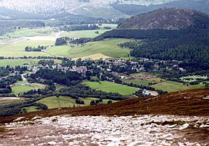
As you get closer to the top, you'll see Braemar village from high above. The very top of Morrone has a radio mast and buildings. These were built in 1969 and are part of a research station for the University of Aberdeen. The Braemar mountain rescue team also has a radio station here. At the highest point, there's a trig point (a marker used for surveying) and a large pile of stones called a cairn.
Amazing Views from the Top
The view from Morrone's summit is incredible! You can see mountains all around, from the Cairngorms to Lochnagar and the Glenshee Ski Centre. When you're ready to come down, you can follow the vehicle track that serves the summit buildings. This track goes south and then east, ending on an old military road in Glen Clunie. From there, it's a short walk back to Braemar.
 | Janet Taylor Pickett |
 | Synthia Saint James |
 | Howardena Pindell |
 | Faith Ringgold |


