Moulton, Alabama facts for kids
Quick facts for kids
Moulton, Alabama
|
|
|---|---|

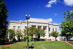
Lawrence County Courthouse
|
|

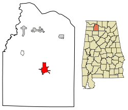
Location of Moulton in Lawrence County, Alabama.
|
|
| Country | United States |
| State | Alabama |
| County | Lawrence |
| Incorporated | December 17, 1819 |
| Area | |
| • Total | 6.01 sq mi (15.56 km2) |
| • Land | 5.99 sq mi (15.53 km2) |
| • Water | 0.01 sq mi (0.04 km2) |
| Elevation | 643 ft (196 m) |
| Population
(2020)
|
|
| • Total | 3,398 |
| • Density | 566.90/sq mi (218.87/km2) |
| Time zone | UTC-6 (Central (CST)) |
| • Summer (DST) | UTC-5 (CDT) |
| ZIP code |
35650
|
| Area code(s) | 256 |
| FIPS code | 01-51600 |
| GNIS feature ID | 2404314 |
Moulton is a city located in Lawrence County, Alabama. It is part of the larger Decatur Metropolitan Area. Moulton became an official city in 1819. However, it was not listed in the U.S. Census until 1900.
In 2010, the city's population reached its highest number with 3,471 people. Moulton has been the main city, or county seat, of Lawrence County since 1820. It has also been the largest community in the county since the 1920 U.S. Census.
Contents
History of Moulton
By 1819, when Alabama became a state, a place for travelers to stay (an inn) was built where Moulton is now. This inn helped people traveling along the early roads in the area. Soon after Alabama became a state, Moulton and a city to its north called Courtland both became official cities. They both wanted to be the county seat of Lawrence County.
The governor at the time, Thomas Bibb, chose Moulton. He picked Moulton because it was more in the center of the county. The city is named after Lieutenant Michael Moulton. He was a soldier who died fighting with General Andrew Jackson in the Battle of Horseshoe Bend in 1814.
Geography of Moulton
Moulton is located at 34°28′56″N 87°17′8″W / 34.48222°N 87.28556°W. The city is mainly found along Alabama State Route 33, southwest of Decatur. Other main roads, Alabama State Route 24 and Alabama State Route 157, also pass through different parts of the city. The William B. Bankhead National Forest is located to the southwest of Moulton.
The U.S. Census Bureau states that Moulton covers a total area of about 6 square miles (15.5 square kilometers). All of this area is land.
Moulton's Climate
Moulton has a humid subtropical climate. This means it usually has hot, humid summers and mild winters. It gets rain throughout the year.
| Climate data for Moulton, Alabama, 1991–2020 normals, extremes 1957–present | |||||||||||||
|---|---|---|---|---|---|---|---|---|---|---|---|---|---|
| Month | Jan | Feb | Mar | Apr | May | Jun | Jul | Aug | Sep | Oct | Nov | Dec | Year |
| Record high °F (°C) | 78 (26) |
85 (29) |
87 (31) |
90 (32) |
96 (36) |
103 (39) |
106 (41) |
103 (39) |
102 (39) |
96 (36) |
86 (30) |
79 (26) |
106 (41) |
| Mean maximum °F (°C) | 69.8 (21.0) |
74.2 (23.4) |
80.6 (27.0) |
84.7 (29.3) |
88.8 (31.6) |
93.4 (34.1) |
95.5 (35.3) |
95.7 (35.4) |
92.9 (33.8) |
86.3 (30.2) |
78.2 (25.7) |
70.7 (21.5) |
97.3 (36.3) |
| Mean daily maximum °F (°C) | 50.6 (10.3) |
54.8 (12.7) |
63.4 (17.4) |
72.0 (22.2) |
79.1 (26.2) |
85.8 (29.9) |
88.4 (31.3) |
88.4 (31.3) |
83.6 (28.7) |
73.5 (23.1) |
61.9 (16.6) |
53.2 (11.8) |
71.2 (21.8) |
| Daily mean °F (°C) | 40.3 (4.6) |
43.8 (6.6) |
51.9 (11.1) |
60.3 (15.7) |
68.3 (20.2) |
75.3 (24.1) |
78.4 (25.8) |
77.8 (25.4) |
72.1 (22.3) |
61.0 (16.1) |
50.1 (10.1) |
42.9 (6.1) |
60.2 (15.7) |
| Mean daily minimum °F (°C) | 30.0 (−1.1) |
32.9 (0.5) |
40.3 (4.6) |
48.6 (9.2) |
57.4 (14.1) |
64.9 (18.3) |
68.4 (20.2) |
67.2 (19.6) |
60.7 (15.9) |
48.5 (9.2) |
38.3 (3.5) |
32.6 (0.3) |
49.2 (9.5) |
| Mean minimum °F (°C) | 12.6 (−10.8) |
16.9 (−8.4) |
22.4 (−5.3) |
31.7 (−0.2) |
42.3 (5.7) |
54.1 (12.3) |
60.6 (15.9) |
58.8 (14.9) |
45.8 (7.7) |
32.1 (0.1) |
22.3 (−5.4) |
18.2 (−7.7) |
9.9 (−12.3) |
| Record low °F (°C) | −13 (−25) |
−8 (−22) |
0 (−18) |
23 (−5) |
33 (1) |
41 (5) |
52 (11) |
50 (10) |
35 (2) |
25 (−4) |
12 (−11) |
−5 (−21) |
−13 (−25) |
| Average precipitation inches (mm) | 5.33 (135) |
5.63 (143) |
5.72 (145) |
5.45 (138) |
5.18 (132) |
4.57 (116) |
5.06 (129) |
4.25 (108) |
4.05 (103) |
4.21 (107) |
4.37 (111) |
6.39 (162) |
60.21 (1,529) |
| Average snowfall inches (cm) | 0.5 (1.3) |
0.9 (2.3) |
0.5 (1.3) |
0.0 (0.0) |
0.0 (0.0) |
0.0 (0.0) |
0.0 (0.0) |
0.0 (0.0) |
0.0 (0.0) |
0.0 (0.0) |
0.0 (0.0) |
0.2 (0.51) |
2.1 (5.41) |
| Average precipitation days (≥ 0.01 in) | 11.9 | 11.6 | 12.7 | 9.7 | 10.4 | 10.6 | 11.3 | 9.6 | 7.6 | 7.6 | 8.9 | 12.0 | 123.9 |
| Average snowy days (≥ 0.1 in) | 0.4 | 0.4 | 0.2 | 0.0 | 0.0 | 0.0 | 0.0 | 0.0 | 0.0 | 0.0 | 0.0 | 0.3 | 1.3 |
| Source 1: NOAA | |||||||||||||
| Source 2: National Weather Service | |||||||||||||
People of Moulton
| Historical population | |||
|---|---|---|---|
| Census | Pop. | %± | |
| 1900 | 290 | — | |
| 1910 | 354 | 22.1% | |
| 1920 | 519 | 46.6% | |
| 1930 | 639 | 23.1% | |
| 1940 | 752 | 17.7% | |
| 1950 | 1,384 | 84.0% | |
| 1960 | 1,716 | 24.0% | |
| 1970 | 2,470 | 43.9% | |
| 1980 | 3,197 | 29.4% | |
| 1990 | 3,248 | 1.6% | |
| 2000 | 3,260 | 0.4% | |
| 2010 | 3,471 | 6.5% | |
| 2020 | 3,398 | −2.1% | |
| U.S. Decennial Census 2013 Estimate |
|||
2020 Census Information
| Race | Num. | Perc. |
|---|---|---|
| White (non-Hispanic) | 2,474 | 72.81% |
| Black or African American (non-Hispanic) | 416 | 12.24% |
| Native American | 99 | 2.91% |
| Asian | 20 | 0.59% |
| Pacific Islander | 1 | 0.03% |
| Other/Mixed | 223 | 6.56% |
| Hispanic or Latino | 165 | 4.86% |
As of the 2020 United States census, Moulton had 3,398 people living there. There were 1,457 households and 815 families in the city.
2010 Census Information
In 2010, there were 3,471 people living in Moulton. These people lived in 1,482 households, and 912 of these were families. The city had about 552 people per square mile.
Most of the people in Moulton were White (78.2%). About 13.1% were Black or African American, and 4.1% were Native American. A small number were Asian (0.4%) or from other races. About 1.6% of the population identified as Hispanic or Latino.
Out of all the households, 25.4% had children under 18 living with them. About 43.7% were married couples. Also, 14.0% of households had a female head without a husband present. Many households (36.1%) were made up of people living alone. About 18.1% of these were people aged 65 or older.
The average household had 2.19 people, and the average family had 2.84 people. The median age in the city was 41 years old. This means half the people were younger than 41 and half were older.
Media in Moulton
Moulton has one radio station, WALW-LP (97.9 FM). The only newspaper for the county, The Moulton Advertiser, is also located in Moulton.
In the 1976 movie Stay Hungry, a character named Newton, played by Roger Mosley, mentions that he wants to move to Moulton and start a large chicken farm.
Transportation
State Highways in Moulton
 SR 24
SR 24 SR 33 (Market Street)
 SR 36
SR 36 SR 157
Notable People from Moulton
- Jim Blevins: A former Head Football Coach at Jacksonville State University.
- Edward B. Almon: Served as a U.S. Representative for Alabama from 1915 to 1933.
- Lucas Black: An actor known for movies like Friday Night Lights and Fast and the Furious: Tokyo Drift.
- Mary Lee Cagle: One of the first important women pastors in the Church of the Nazarene.
- Asa Hodges: A U.S. representative from Arkansas.
- John Wallace Jones: Served as the Mayor of Shreveport, Louisiana from 1854 to 1858.
- Thomas Minott Peters: A lawyer and botanist.
- Phillip Roddey: A brigadier general in the Confederate army during the American Civil War.
- David Stewart: An American football offensive tackle who graduated from Lawrence County High School.
See also
 In Spanish: Moulton (Alabama) para niños

