
Mount Bigelow (Maine) facts for kids
Quick facts for kids Mount Bigelow |
|
|---|---|

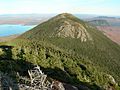
Avery Peak (right), West Peak (left).
|
|
| Highest point | |
| Elevation | 4,145 ft (1,263 m) |
| Prominence | 2,845 ft (867 m) |
| Listing | New England 4000 footers |
| Geography | |

Mount Bigelow
Location in Maine
|
|
| Parent range | Appalachian Mountains |
| Topo map | USGS Stratton, The Horns |
| Climbing | |
| Easiest route | Hiking via the Appalachian Trail. |
Mount Bigelow, also known as the Bigelow Range, is a long mountain ridge in Maine, U.S.. It stretches across parts of Franklin County and Somerset County. This mountain is one of the highest peaks in Maine.
The mountain got its name from Major Timothy Bigelow. He was a soldier who climbed the mountain in October 1775 to look around and observe the area. Major Bigelow was part of an important expedition led by Colonel Benedict Arnold. This group traveled along the Dead River, which is now part of Flagstaff Lake, near the northern edge of the Bigelow Range.
Contents
What are the Main Peaks of Mount Bigelow?
Mount Bigelow has several important peaks. The highest point is West Peak, which stands at 4,145 ft (1,263 m).
Other notable peaks include:
- Avery Peak (also called Myron H. Avery Peak) at 4,088 ft (1,246 m).
- The Horns at 3,805 ft (1,160 m).
- Cranberry Peak at 3,194 ft (974 m).
- Little Bigelow Mountain at about 3,070 ft (940 m).
The Maine Appalachian Trail Club (MATC) helps take care of the hiking trails on Bigelow Mountain. They also have people who stay at popular campsites like Horns Pond and Bigelow Col during certain times of the year to help hikers.
What Mountain Range is Bigelow Part Of?
Bigelow Mountain is part of the Rangeley-Stratton mountain range. This range includes other well-known mountains in Maine, such as Sugarloaf Mountain, Crocker Mountain, Saddleback Mountain, Mount Abraham, and Mount Redington. These mountains are often called Maine's "Blue Mountains" because of how they look from a distance.
Hiking and Conservation on Bigelow Mountain
The famous Appalachian Trail goes right over Bigelow Mountain. A large part of the mountain and the land around it is protected as the Bigelow Preserve. This preserve covers about 10,540-acre (42.7 km2) (which is about 42.65 square kilometers). It was created in 1976 to protect the area from a very large proposed ski resort.
The Appalachian Mountain Club considers both West Peak and Avery Peak to be "four-thousand footers". This means they are mountains that are at least 4,000 feet high. Avery Peak counts because it rises more than 200 feet (61 m) above the low point (called a col) that connects it to the higher West Peak. Even though the South Horn of Bigelow is under 4,000 feet, it also qualifies for the New England Hundred Highest list using similar rules.
In 1975, Bigelow Mountain was recognized as a National Natural Landmark by the National Park Service. This means it's a special natural area that is important to the country.
Images for kids
-
Mount Bigelow, Avery Peak
-
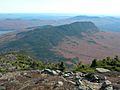
Little Bigelow Mountain
-
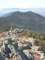
South Horn and North Horn
-
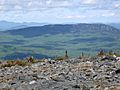
Little Bigelow Mountain as seen from the summit of Burnt Mountain.


