
Mount Kidd facts for kids
Quick facts for kids Mount Kidd |
|
|---|---|
.jpg)
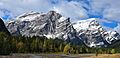
Mount Kidd seen from northbound Highway 40 with south peak on left and north peak on right
|
|
| Highest point | |
| Elevation | 2,958 m (9,705 ft) |
| Prominence | 535 m (1,755 ft) |
| Parent peak | The Tower (3117 m) |
| Geography | |

Mount Kidd
Location in Kananaskis Improvement District

Mount Kidd
Location in Alberta
|
|
| Location | Alberta, Canada |
| Parent range | Kananaskis Range Canadian Rockies |
| Topo map | NTS 82J/14 |
| Geology | |
| Age of rock | Cambrian |
| Type of rock | sedimentary rock |
| Climbing | |
| First ascent | 1947 by R. C. Hind and J.F. Tarrant |
| Easiest route | Scrambling |
Mount Kidd is a very tall mountain in the Canadian Rockies in Alberta, Canada. It stands 2,958-metre (9,705-foot) high and has two main tops, making it a "double-summit" mountain. You can find Mount Kidd in the middle of Kananaskis Country, inside Spray Valley Provincial Park.
Mount Kidd is a famous sight from Highway 40 near Kananaskis Village. You can also see it from the Kananaskis Country Golf Course, which is right at the base of the mountain. The closest taller mountain is The Tower, about 8.0 km (5.0 mi) to the southwest.
Contents
History of Mount Kidd
In 1907, a scientist named Dr. Donaldson Bogart Dowling gave the mountain its name. He named it after John Alfred (Fred) Kidd. Fred Kidd lived in a nearby town called Morley. From 1902 to 1907, he ran a store and helped explorers and scientists like Dowling by providing them with supplies for their trips.
The first time people successfully climbed to the top of Mount Kidd was in 1947. This amazing climb was done by R. C. Hind and J. F. Tarrant. The name "Mount Kidd" was officially recognized in 1953 by the Canadian government's naming board.
How Mount Kidd Was Formed (Geology)
Mount Kidd is made of a type of rock called sedimentary rock. This rock formed over millions of years, from the Precambrian to the Jurassic periods. Sedimentary rock usually forms in shallow seas from layers of sand, mud, and tiny bits of shells.
Later, huge forces pushed these rock layers up and over younger rocks. This big push is part of something called the Laramide orogeny, which helped create the Rocky Mountains. Mount Kidd is special because it marks the northern end of a very long crack in the Earth's crust called the Lewis Overthrust. This crack stretches for over 450 km (280 mi) all the way to Montana in the United States!
Weather at Mount Kidd (Climate)
Mount Kidd has a subarctic climate. This means it has very cold, snowy winters and mild summers. In winter, temperatures can drop below −20 °C (−4 °F). With the wind, it can feel even colder, sometimes below −30 °C (−22 °F)!
Because of these cold winter conditions, Mount Kidd is a great place for ice climbing. The water from the mountain melts and flows into the Kananaskis River. This river then joins the Bow River, which eventually flows into the Saskatchewan River.
Climbing Mount Kidd
Mount Kidd has two main tops: a north peak and a south peak. Both peaks can be climbed using "scramble routes," which means they involve some climbing but don't always need special ropes or gear.
The north peak is the true highest point, reaching 2,958 metres (9,705 feet) (9,705 ft). The south peak is a bit lower at 2,895 metres (9,498 feet) (9,498 ft).
Besides scrambling, Mount Kidd also has harder rock climbing routes. One route on its northeast side is rated 5.7. There's also a 5.8 route called The Fold on the south peak. In 1985, Rudi Kranabitter and Ferdl Taxbock were the first to climb this classic route.
For those who love ice climbing, Mount Kidd offers several exciting routes with different difficulty levels:
- A Bridge Too Far – WI4+
- Kidd Falls – WI4
- Tasting Fear – WI5−
- Wedge Smear – WI3
- Sinatra Falls – WI2
Images for kids
-
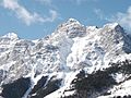
Mount Kidd seen from northbound Highway 40. Notice the interesting rock layers!
-
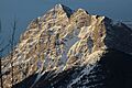
A close-up view of Mount Kidd's East Face.
-
View of Mount Kidd from Kananaskis Village.
-
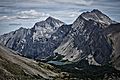
Mount Kidd in the center, South Kidd on the right, and Ribbon Lake in the foreground.

.jpg)


