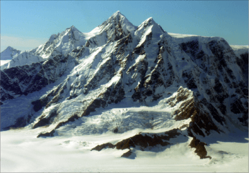
Mount La Perouse facts for kids
Quick facts for kids Mount La Perouse |
|
|---|---|

Mount La Perouse, east aspect
|
|
| Highest point | |
| Elevation | 10,728 ft (3,270 m) |
| Prominence | 2,778 ft (847 m) |
| Parent peak | Mount Crillon (12,726 ft) |
| Geography | |
| Location | Glacier Bay National Park Hoonah-Angoon Alaska, United States |
| Parent range | Fairweather Range Saint Elias Mountains |
| Topo map | USGS Mount Fairweather C-4 |
| Type of rock | Gabbro |
| Climbing | |
| First ascent | 1953 |
| Easiest route | Mountaineering |
Mount La Perouse is a tall, icy mountain in Alaska, United States. It stands 10,728 feet (3,270 meters) high. This amazing peak is part of the Fairweather Range in the Saint Elias Mountains.
You can find Mount La Perouse inside Glacier Bay National Park. It's quite a sight because it rises very steeply from the ocean in just a few miles!
Contents
Discovering Mount La Perouse
Mount La Perouse is a huge mountain covered in ice. It's found in the beautiful Glacier Bay National Park in southeast Alaska. It's about 4 miles (6.4 km) southeast of Mount Dagelet. It's also 7.6 miles (12.2 km) south-southeast of Mount Crillon, which is a taller nearby peak. The highest mountain in this area, Mount Fairweather, is about 28.6 miles (46 km) to the southeast.
How it Got its Name
The mountain was named in 1874 by William Healey Dall. He worked for the United States Geological Survey (USGS). He named it after Jean-François de Galaup, comte de Lapérouse. He was a French explorer who sailed along this coast in 1786.
First Climbers
The first time anyone successfully climbed to the top of Mount La Perouse was in 1953. A team from the USGS made this first ascent. The climbers were James Seitz, Karl Stauffer, Rowland Tabor, Rolland Reid, and Paul Bowen.
A Big Landslide
On February 16, 2014, something huge happened at Mount La Perouse. A massive landslide broke off the side of the mountain. It weighed 68 million tons! This huge slide traveled almost 4.6 miles (7.4 km) from where it started.
Weather and Ice
Mount La Perouse has a subarctic climate. This means it has cold, snowy winters and mild summers. Temperatures can drop below −20 °C (that's -4 °F). With the wind, it can feel even colder, below −30 °C (that's -22 °F).
This cold climate helps keep the mountain covered in ice. You can see glaciers hanging on its slopes. There are also huge glaciers nearby, like the immense Brady Glacier to the east. The Finger Glacier is to the south, and the La Perouse Glacier is to the north and west. Water from melting ice and rain flows from these glaciers into the Gulf of Alaska.
If you want to climb Mount La Perouse or just enjoy the views, the best time to visit is usually from May through June. The weather is most favorable then.
 | James B. Knighten |
 | Azellia White |
 | Willa Brown |


