
Mount Lougheed facts for kids
Quick facts for kids Mount Lougheed |
|
|---|---|

Mount Lougheed (Peak 1 centered)
|
|
| Highest point | |
| Elevation | 3,107 m (10,194 ft) |
| Prominence | 242 m (794 ft) |
| Parent peak | Wind Mountain (3153 m) |
| Listing | Mountains of Alberta |
| Geography | |

Mount Lougheed
Location in Alberta

Mount Lougheed
Location in Canada
|
|
| Location | Alberta, Canada |
| Parent range | Canadian Rockies |
| Topo map | NTS 82J/14 |
| Geology | |
| Age of rock | Cambrian |
| Type of rock | Palliser limestone |
| Climbing | |
| First ascent | 1889 by A. St. Cyr, W.S. Drewry, Tom Wilson |
| Easiest route | Climbing YDS 5.5 |
Mount Lougheed is a very tall mountain in the Canadian Rockies of Alberta, Canada. It stands 3,107-metre (10,194-foot) high. This mountain has three main peaks. It is located between the Spray Lakes Reservoir and the Wind Valley in Kananaskis Country.
The highest point is called Peak 2, reaching 3,107 metres. Peak 1, to the northwest, is 3,080 metres tall. Peak 3, to the southeast, is 3,010 metres high. The closest taller mountain is Wind Mountain, about 2.0 km (1.2 mi) away. Mount Lougheed is easy to spot from Highway 1, also known as the Trans-Canada Highway, near Dead Man's Flats and Canmore.
Mountain History
Mount Lougheed is named after Sir James Lougheed (1854–1925). He was a very important person in Canadian politics. He worked as a lawyer, a politician, and a senator. He also served as a cabinet minister, which means he was part of the government's main decision-making group.
The mountain was first called Wind Mountain by Eugène Bourgeau. He was part of the Palliser Expedition that explored the area. But in 1928, after Sir James Lougheed passed away, the mountain was renamed to honor him. The official name was approved by the Geographical Names Board of Canada in 1928. The first people to climb Mount Lougheed were A. St. Cyr, W.S. Drewry, and Tom Wilson in 1889.
How the Mountain Formed (Geology)
Mount Lougheed is made mostly of a type of rock called Palliser limestone. Limestone is a sedimentary rock. This means it formed from layers of tiny bits of sand, shells, and other materials that settled at the bottom of ancient seas. Over millions of years, these layers were pressed together and turned into rock.
The rocks that make up Mount Lougheed were formed a very long time ago. This happened during the Precambrian to Jurassic periods. Later, powerful forces inside the Earth pushed these rocks up. This event is known as the Laramide orogeny. It caused the sedimentary rock to move east and even slide over younger rock layers. This is how the tall mountains we see today were created.
Mountain Climate
Mount Lougheed is in a subarctic climate zone. This means it has very cold and snowy winters. The summers are usually mild. Temperatures can often drop below −20 °C. With the wind, it can feel even colder, sometimes below −30 °C.
The snow and rain that fall on Mount Lougheed eventually melt and flow down the mountain. This water then drains into the Bow River. The Bow River is a major river that flows into the Saskatchewan River.
Images for kids
-
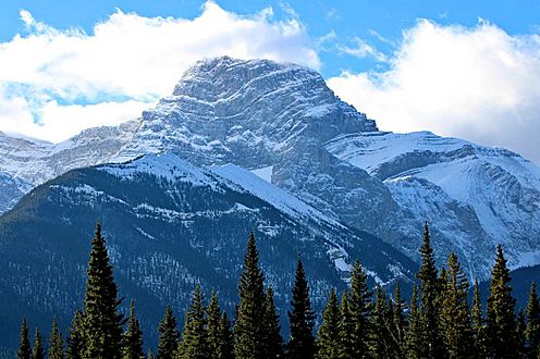
Mount Lougheed Peak 1
-
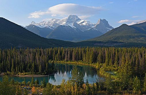
Mt. Lougheed flanked by Wind Mountain and Windtower
.jpg)

