Mount Stanford facts for kids
Quick facts for kids Mount Stanford |
|
|---|---|

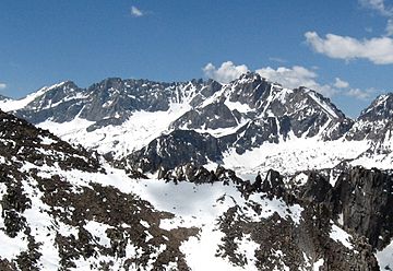
Mount Stanford's profile from Mount Gould to the north, May 2009.
|
|
| Highest point | |
| Elevation | 13,979 ft (4,261 m) NAVD 88 |
| Prominence | 981 ft (299 m) |
| Parent peak | Mount Keith |
| Listing | Sierra Peaks Section |
| Geography | |
| Location | Kings Canyon National Park, Tulare County, California, U.S. |
| Parent range | Sierra Nevada |
| Topo map | USGS Mount Brewer |
| Climbing | |
| First ascent | 1896 by Bolton Brown |
| Easiest route | Exposed scramble, class 3 |
Mount Stanford is a tall mountain located in Kings Canyon National Park. It stands at an elevation of about 13,979 feet (4,261 meters). This makes it one of the highest mountains in California, ranking as the fifteenth tallest.
The mountain is part of the Kings-Kern Divide, a high ridge in the Sierra Nevada mountain range. It was named after Stanford University, a famous school in California. Mount Stanford is also quite close to University Peak, another mountain named after the University of California.
Contents
Why is it called Mount Stanford?
Mount Stanford got its name thanks to a professor named Bolton Coit Brown. He was a professor at Stanford University.
The First Climb and Naming
On August 1, 1896, Professor Brown was the first person to officially climb Mount Stanford. After his climb, he asked for the mountain to be named "Mount Stanford."
There was already another peak called Stanford Peak in a different area, Placer County. So, Professor Brown suggested a backup name: "Stanford University Peak." Luckily, the other peak was renamed Castle Peak. This meant Brown's first choice, Mount Stanford, was accepted for the peak he climbed.
A Presidential Visit
Three years later, on August 16, 1899, the president of Stanford University, David Starr Jordan, also climbed Mount Stanford. He went with his wife and a group of people from Stanford. President Jordan had experience climbing in the Alps, a major mountain range in Europe.
Another Stanford Peak
In 1911, the U.S. Geological Survey (USGS) named another peak in honor of Leland Stanford. He was a very successful businessman, a politician, and the person who founded Stanford University.
This other peak was first called Stanford Peak. However, in 1982, the USGS changed its name to Mount Stanford. This second Mount Stanford is about 12,838 feet (3,913 meters) tall. It is located about 59 miles (95 kilometers) north-northeast of the main Mount Stanford. This peak overlooks Pioneer Basin in the John Muir Wilderness.
How to get to Mount Stanford
Climbing Mount Stanford is considered an "exposed scramble." This means it involves climbing over rocky areas where you might feel very high up. It is rated as a Class 3 climb on the Yosemite Decimal System (YDS).
Best Time to Climb
Experienced mountaineers can climb Mount Stanford without needing ropes or special climbing gear. The best time to do this is during the late summer months. This is when the weather is usually good and there is less snow.
Starting Your Journey
The easiest way to reach Mount Stanford is from the Onion Valley trailhead. A trailhead is the starting point for a hiking trail. Onion Valley is located west of Independence. You can find Independence off U.S. Route 395, a major highway.
 | Delilah Pierce |
 | Gordon Parks |
 | Augusta Savage |
 | Charles Ethan Porter |

