Murrells Inlet, South Carolina facts for kids
Quick facts for kids
Murrells Inlet, South Carolina
|
|
|---|---|
 |
|
| Nickname(s):
Seafood Capital of South Carolina
|
|

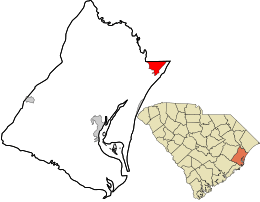
Location in Georgetown County and the state of South Carolina
|
|
| Country | United States |
| State | South Carolina |
| County | Georgetown |
| Area | |
| • Total | 7.48 sq mi (19.36 km2) |
| • Land | 7.32 sq mi (18.95 km2) |
| • Water | 0.16 sq mi (0.42 km2) |
| Elevation | 3 ft (0.9 m) |
| Population
(2020)
|
|
| • Total | 9,740 |
| • Density | 1,331.51/sq mi (514.10/km2) |
| Time zone | UTC-5 (EST) |
| • Summer (DST) | UTC-4 (EDT) |
| ZIP Code |
29576
|
| FIPS code | 45-48985 |
| GNIS feature ID | 1253479 |
Murrells Inlet is a special kind of community in Georgetown County, South Carolina, United States. It's called an unincorporated area and a census-designated place. This means it's not a city with its own government, but it's a recognized place where people live.
In 2020, about 9,740 people lived here. Murrells Inlet is located about 13 miles (21 km) south of Myrtle Beach, South Carolina. It is also about 21 miles (34 km) north of Georgetown, which is the main town of the county.
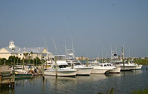
Long ago, Murrells Inlet was mostly a fishing village. Today, it's a popular spot for tourists and people who want to retire. It's famous for the Murrells Inlet Marshwalk. This is a 1⁄2-mile-long (0.8 km) boardwalk that goes over a salt marsh. You can find many restaurants along this boardwalk.
Contents
Exploring Murrells Inlet
Where is Murrells Inlet?
Murrells Inlet is in the northeastern part of Georgetown County. It sits at 33°33′6″N 79°2′56″W / 33.55167°N 79.04889°W. The northern edge of the community touches the border of Horry County.
A main road, U.S. Route 17, runs right through the middle of Murrells Inlet. This highway takes you northeast to Myrtle Beach and southwest to Georgetown.
Climate and Nature
Murrells Inlet has a humid subtropical climate. This means it has hot, humid summers and mild winters. The average monthly temperatures range from about 46.5 °F (8 °C) in January to 80.5 °F (27 °C) in July.
The area is known for its beautiful natural surroundings. It has a mix of land and water, with many creeks and the nearby Atlantic Ocean.
A Look Back in Time: Murrells Inlet's History
Early People and Land
People have lived around Murrells Inlet for thousands of years. Long before written history, Native American groups lived here. They used the natural resources from the creeks and rivers. The Waccamaw people were living here when Europeans first arrived.
Archaeologists have found shell mounds and other items from these early cultures. These findings show how they lived and used the land. Some ancient burial sites have also been found. They contained items like European beads, showing early trade.
Colonial Times and Plantations
The written history of Murrells Inlet began with English settlers. The Lords Proprietors were the owners of the Carolina colony. They gave out large pieces of land to people who would bring workers and settle the area. These huge land grants were called baronies. They often stretched from the Atlantic Ocean to the Waccamaw River.
These large estates were divided into many plantations. Each plantation could be from 500 to 1,500 acres (200 to 610 ha) in size. Some of the famous plantations in Murrells Inlet were The Oaks, Brookgreen, Springfield, Laurel Hill, Richmond Hill, and Wachesaw.
The first planters came in the 1730s. They started farming and building settlements. Captain John Murrell bought 2,340 acres (950 ha) of land. He built a house around 1733. He grew indigo, a plant used to make blue dye, as his main crop. The area was likely named "Murrells Inlet" after his family.
Later, rice became the most important crop in the region. Plantations like Wachesaw and Richmond Hill became very successful. Many wealthy families owned these plantations. They were important leaders in the state government.
The End of an Era
The time of large rice plantations ended after the American Civil War. This war led to the freedom of enslaved people. Rice farming needed a lot of labor, and without enslaved workers, it became very difficult to grow.
Also, a series of strong hurricanes hit the area. A very powerful hurricane in 1893 caused a lot of damage. These storms, along with the changes after the Civil War, led to the end of rice farming on the Waccamaw Neck.
New Beginnings
After the plantation era, new people started moving to Murrells Inlet. They came to enjoy the natural beauty and resources. Families from nearby towns like Marion and Conway settled here.
In the 1920s and 1930s, some of the old plantations were bought by wealthy people. They wanted to use the land for hunting or as retreats. For example, William A. Kimbel bought Wachesaw and Richmond Hill to create a large hunting estate.
A famous author, Julia Mood Peterkin, visited Brookgreen plantation. She used the area as a setting for some of her novels. She even won a special award called the Pulitzer Prize for Fiction for her book Scarlet Sister Mary in 1928.
Later, a railroad owner named Archer Milton Huntington and his wife, Anna Hyatt Huntington, bought Brookgreen in 1930. They turned it into an amazing outdoor gallery for Anna's sculptures. They also built Atalaya, a Spanish-style fort, on the beach. Today, this area is Huntington Beach State Park.
Travel and Roads
In the past, people traveled by boat on the Waccamaw River or the Atlantic Ocean. There were also rough dirt paths for horses and wagons. One of these was the Kings Road, which George Washington once used.
Around 1933, Highway 17 was paved. This was part of a big effort to build paved roads across the United States. This made travel much easier for everyone.
Historic Landmarks
Murrells Inlet has several important places listed on the National Register of Historic Places. These are special sites that are protected because of their history:
- Atalaya
- Murrells Inlet Historic District
- Richmond Hill
People of Murrells Inlet
Population Today
| Historical population | |||
|---|---|---|---|
| Census | Pop. | %± | |
| 2020 | 9,740 | — | |
| U.S. Decennial Census | |||
As of the 2020 United States census, there were 9,740 people living in Murrells Inlet. There were 4,129 households, which are groups of people living together.
| Race | Num. | Perc. |
|---|---|---|
| White (non-Hispanic) | 8,682 | 89.14% |
| Black or African American (non-Hispanic) | 478 | 4.91% |
| Native American | 19 | 0.2% |
| Asian | 57 | 0.59% |
| Other/Mixed | 281 | 2.89% |
| Hispanic or Latino | 223 | 2.29% |
Who Lives Here?
In 2010, the average household had about 2.14 people. The average family had about 2.59 people.
The population included people of all ages. About 15.5% were under 18 years old. Many adults were between 45 and 64 years old (31.5%). About 21.3% of the people were 65 years or older. The average age was 47 years old.
Famous Faces from Murrells Inlet
Some well-known people have connections to Murrells Inlet:
- Wendi Nix, a sports analyst for ESPN
- Mickey Spillane, a famous author who wrote the Mike Hammer detective novels
See also
 In Spanish: Murrells Inlet para niños

