
Mynydd-y-Gaer facts for kids
Quick facts for kids Mynydd-y-Gaer |
|
|---|---|

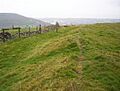
Iron age hillfort west of the summit of Mynydd-y-Gaer
|
|
| Highest point | |
| Elevation | 314 m (1,030 ft) |
| Prominence | 80 m |
| Parent peak | Foel Fynyddau |
| Listing | Tumps |
| Naming | |
| English translation | hill of the fort |
| Language of name | Welsh |
| Geography | |

Mynydd-y-Gaer
Location in Neath Port Talbot
|
|
| OS grid | SS767936 |
| Topo map | OS Landranger 170 / Explorer 165 |
Mynydd-y-Gaer is a hill in South Wales. It sits between the towns of Baglan, Cwmavon, and Briton Ferry. These towns are all in the Neath Port Talbot area.
The top of the hill is 314 meters (1,030 feet) high. It has grassy fields with old stone walls. To the east, you can see Foel Fynyddau hill. To the south is the Bristol Channel coast. The Vale of Neath is to the west. North of the hill is the Crythan Brook and the town of Neath. This hill has many ancient sites. People lived here long ago, even in medieval times. Coal mining also took place here in the 1800s and 1900s.
Contents
Ancient History of Mynydd-y-Gaer
Mynydd-y-Gaer is home to several very old sites. These sites tell us about people who lived here thousands of years ago.
Iron Age Hillforts on the Hill
Three special ancient places are found on the hill. They are called scheduled monuments. All of them are from the Iron Age. This time period was about 800 BC to AD 100.
- Near the top of the hill is a large fort called Buarth-y-Gaer.
- On the south-west side, near Baglan, is a smaller fort named Craig Ty-Isaf.
- A third fort, Gaer Fawr, is about 800 meters (half a mile) from the top. It is on the northern part of the hill.
Bronze Age Burial Sites
People also built burial mounds here during the Bronze Age. This was an even older time, from about 3300 BC to 1200 BC.
- One burial mound is near the top of the hill. It is inside the Buarth-y-Gaer fort.
- At the Gaer Fawr fort, there is a group of five burial mounds. There might have been as many as 19, but some were lost over time.
- Another burial mound is on the ridge between the two main forts.
Life in Medieval Times
Records show that a village once existed on Mynydd-y-Gaer during medieval times. This was a period from about the 5th to the 15th century. We don't know the exact spot of the village.
One old house platform has been found on the east side of the hill. A small road crosses the hill in this area. It runs between Mynydd-y-Gaer and Foel Fynyddau. This road also passes by old coal mining tunnels. These tunnels likely date back to the 1800s.
Coal Mining History
Even though there's no coal mining on the hill today, it was a busy place in the early 1900s. Many smaller tunnels were dug on the east side of the hill to get coal.
Cwm Mawr Colliery Operations
A bigger mine, called Cwm Mawr colliery, started a new tunnel around 1920. This tunnel went into the side of Mynydd-y-Gaer. From 1922, a company called Briton Ferry Collieries Ltd owned it. They hired over 100 men to work in the Cwm Mawr mines for 20 years. The mine closed in 1944. It briefly reopened in 1950 before closing for good.
Eskyn Colliery Development
On the northern tip of Mynydd-y-Gaer, the Eskyn Colliery was built. This mine started in the early 1900s. Workers built a water channel, an engine house, a railway for coal, and piles of waste rock. You can still see these today. However, this mine did not last long. It was listed as closed by 1919.
Exploring Mynydd-y-Gaer
There are no official walking paths that go directly to the top of Mynydd-y-Gaer. However, there are ways to explore parts of the hill.
Roads and Forest Access
On the eastern side, a small road crosses a high point about 80 meters (260 feet) below the summit. You might be able to walk on the paths in the Forestry Commission's Margam Forest.
Briton Ferry Woods Trails
On the western side of the hill are the Briton Ferry Woods. These woods have a mix of planted trees and native broadleaf trees. They cover a large part of the hill's slopes. There are many paths and trails here for walking. The Wales Coast Path also has a section that runs along the edge of these woods.
Historic Railway Line
In 1861, the Ynysmaerdy Railway Incline opened. This railway ran along the northern edge of the hill. It was used to carry coal down to the docks at Briton Ferry. The railway line stopped operating in 1910.
Images for kids
-
Iron age hillfort west of the summit of Mynydd-y-Gaer
