Neales Flat, South Australia facts for kids
Quick facts for kids Neales FlatSouth Australia |
|||||||||||||||
|---|---|---|---|---|---|---|---|---|---|---|---|---|---|---|---|

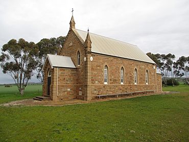
Neales Flat Lutheran Church, formerly St John's Lutheran Church constructed 1912
|
|||||||||||||||
| Postcode(s) | 5374 | ||||||||||||||
| LGA(s) | Regional Council of Goyder | ||||||||||||||
| State electorate(s) | Stuart | ||||||||||||||
| Federal Division(s) | Grey | ||||||||||||||
|
|||||||||||||||
Neales Flat is a small country area in South Australia. It's located southeast of a town called Eudunda. This area is part of the Regional Council of Goyder. It's also within specific government voting areas for South Australia and Australia.
Contents
Where Did the Name Neales Flat Come From?
The area of Neales Flat was named after John Bentham Neales. He was a politician in South Australia. People called him the "Father of Mining" because he was important in starting mining in the region.
A Look at Neales Flat's History
Neales Flat once had three different Lutheran churches. Over time, these churches joined together. Now, only one church group remains. This group also shares services with the church in nearby Peep Hill.
Today, it's part of the "Eudunda Robertstown Lutheran Parish." This parish includes Lutheran churches in several towns. These towns are Robertstown, Point Pass, Geranium Plains, Eudunda, Neales Flat, and Peep Hill.
How the Churches Combined
The first Lutheran people in the area met in homes starting in 1871. They built St Stephan's Lutheran Church in 1874. Another group, St Paul's, built their own church in 1874. They built a larger church next to it in 1893. The first St Paul's building then became a school.
This school became a government school in 1917 and closed in 1942. The St John's church group used the school building from 1894. Then, in 1912, they built their own church right next to the school.
In 1967, different Lutheran church groups joined together. Because of this, St John's and St Paul's churches combined. They met in the St Paul's building and called themselves Trinity Lutheran Church. Later, in 2009, St Stephan's church joined Trinity. They formed the Neales Flat Lutheran Church. This new church meets in the old St John's building. There is a cemetery behind these two church buildings. Another cemetery is near the old St Stephan's church, which has been sold.
Exploring Narcoota
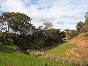
Narcoota and Narcoota Springs are located in a valley. This valley is in the south of the Eudunda area, close to Neales Flat. This spot was very important in the early history of South Australia.
Narcoota Springs is found at Section 350, Hundred of Dutton, South Australia. It's at the eastern edge of the Mount Lofty Ranges. The springs are about 12 kilometers south of Eudunda. They are in a valley along Narcoota Creek.
What Does Narcoota Mean?
Narcoota is an Indigenous name for the area. Its exact meaning isn't clear. It might be a changed version of 'Narcoona,' which means 'seeing.' This could refer to the area being a good lookout point over the Murray Plains. Early European settlers used the name from the beginning. However, they spelled it in different ways, like Nancoota or Tharcoota.
A Vital Stop for Early Explorers
Narcoota Springs was a busy place for early explorers and drovers. Drovers were people who moved large groups of animals. The springs were a rare source of permanent water. This made them a perfect stop before the dry Murray Plains.
It was the western end of the Narcoota Track. From 1838 to 1842, this track was part of the main road. It was the first road connecting the Murray River to Adelaide. The eastern end of the track was called The Pound. This spot later became McBean Pound at Roonka Station.
The overland road split at The Pound. One path went south towards Mount Barker. The other went west to Narcoota, then on to Gawler Town and Adelaide.
Many important people visited Narcoota Springs. These included Governor George Gawler and explorer Charles Sturt. Henry Inman, who was a police commander, also passed through at least five times.
Important Journeys Through Narcoota
In 1839, Henry Inman led a police group to the Weston Flat area. They were investigating a conflict where an overlander and some Aboriginal people died. Months later, he returned as part of Governor Gawler's exploration trip.
In 1841, Inman was there again after his own droving group was attacked. He lost 5,000 sheep in the attack. He also camped there as part of a large police group. This group was led by Commissioner of Police Thomas Shuldham O'Halloran. They were sent to protect other drovers at the Rufus River.
After a settlement was built in late 1841 by Edward John Eyre at Moorundie, the overland route changed. It moved further south, generally following the present Sturt Highway. This new route was between Blanchetown and Truro. Because of this, the Narcoota Track was no longer used.
Narcoota's Later Development
Later in the 1840s, a large farm called Narcoota Station was set up. Nearby is Mount Rufus, where gold was found in 1868. However, not much gold was found there.
In the late 1800s, more farmers moved into the area. By 1900, there were busy schools and churches. Today, many stone ruins show that some early settlements didn't last. But these early efforts created the farms and grazing properties that are successful there now.
Narcoota's Geology
The rock layers found along Narcoota Creek are very typical. They show the structure and layers of geological features found in many places. These places are throughout the North Mount Lofty Ranges. Because of this, the name Narcoota Series has been given to this entire group of geological features.
 | Delilah Pierce |
 | Gordon Parks |
 | Augusta Savage |
 | Charles Ethan Porter |


