
Nesslau facts for kids
Quick facts for kids
Nesslau
|
|
|---|---|

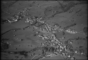
Nesslau village
|
|

Nesslau
Location in Switzerland

Nesslau
Location in Canton of St. Gallen
|
|
| Country | Switzerland |
| Canton | St. Gallen |
| District | Toggenburg |
| Area | |
| • Total | 92.7 km2 (35.8 sq mi) |
| Population
(Dec 2020 )
|
|
| • Total | 3,608 |
| • Density | 38.921/km2 (100.81/sq mi) |
| Postal code |
9650 / 9651 / 9652 / 9643 / 9655
|
| Surrounded by | Alt Sankt Johann, Amden, Ebnat-Kappel, Hemberg, Hundwil (AR), Schänis, Urnäsch (AR), Wildhaus |
Nesslau is a municipality in the Toggenburg district of the canton of St. Gallen, Switzerland. It's a beautiful place with a rich history.
The current municipality of Nesslau was created in 2013. It includes the villages of Nesslau, Krummenau, and Stein.
Contents
History of Nesslau
The area where Nesslau is located became part of the lands belonging to the counts of Toggenburg and the Abbey of St. Gall starting in the 1100s.
Nesslau was first mentioned in old writings in 1178. Back then, it was called Mezellouo. Later, in 1261, it was known as Nesselove. The small village of Lutenwil was mentioned even earlier, in 912. Krummenau first appeared in records in 1266.
From the 1500s, Sidwald became a busy place for selling cattle. It grew into an important regional market.
After some fires damaged the Benedictine abbey of St. John's, the monks moved. In 1626, the monastery was rebuilt in a new spot near Sidwald. This new location was called Neu St. Johann.
From 1831 to 2002, Nesslau was an important administrative center. It was the main town for the Obertoggenburg area.
In 1912, a railway line opened, connecting Ebnat-Kappel to Nesslau-Neu St. Johann. This new train line helped tourism grow a lot in the region. Many people started visiting the beautiful area.
The municipality of Nesslau has changed over time. In 2005, the old municipality of Nesslau joined with Krummenau. They formed a new municipality called Nesslau-Krummenau. Then, in 2013, this new municipality merged again with Stein. This final merger created the Nesslau municipality we know today.
Geography of Nesslau

The new municipality of Nesslau covers a large area of about 92.72 square kilometers (35.8 square miles).
A big part of the land, about 53.8%, is used for farming. Farmers grow crops or raise animals there. Forests cover another large section, about 36.5% of the land. This means there are many trees and natural areas.
Only a small part, about 3.2%, is settled with buildings or roads. The remaining 6.6% of the land is non-productive. This includes rivers like the Thur and lakes.
The municipality is located on both sides of the Thur river. It stretches between the mountains of Speer and Stockberg. It also goes from the Silberplatten in the Säntis mountain range, over the Schwägalp Pass, to Mistelegg.
Nesslau includes several villages and small communities. These are Nesslau, Krummenau, Neu St. Johann, Dorf, and Ennetbühl. There are also smaller hamlets like Lutenwil, Krümmenschwil, Büel, Schneit, Laad, Schlatt, Aemelsberg, and Beiereggbis.
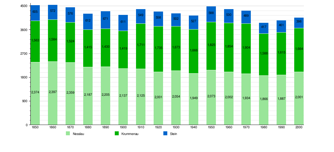
Historic Population Changes
The chart below shows how the number of people living in Nesslau, Krummenau, and Stein has changed over many years. You can see how the population grew or shrunk in each area.
Important Sights in Nesslau

The village of Stein has two interesting churches you can visit.
- The Reformed church was built a very long time ago, in 1497. It was updated in 1929. Its north tower has a special roof shape called a gable.
- The Catholic church of St. Jacob was built more recently, in 1927-28. However, its beautiful Rococo-style pulpit is much older, from 1770.
National Heritage Sites

Some places in Nesslau are so important that they are listed as Swiss heritage sites of national significance. This means they are protected because of their history or special design.
- The house at Sidwaldstrasse 6 is one of these important sites.
- The former Benedictine Abbey of Neu St. Johann is also a national heritage site. It's a very old and significant building.
- The entire village of Ennetbühl is recognized as part of the Inventory of Swiss Heritage Sites. This means the whole village has special historical value.
