Netherthorpe, Sheffield facts for kids
Quick facts for kids Netherthorpe |
|
|---|---|
| OS grid reference | SK343876 |
| Metropolitan borough | |
| Metropolitan county | |
| Region | |
| Country | England |
| Sovereign state | United Kingdom |
| Post town | SHEFFIELD |
| Postcode district | S3 |
| Dialling code | 0114 |
| Police | South Yorkshire |
| Fire | South Yorkshire |
| Ambulance | Yorkshire |
| EU Parliament | Yorkshire and the Humber |
| UK Parliament |
|
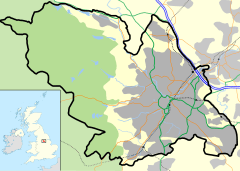
Netherthorpe is a neighborhood in the city of Sheffield, England. It is about one mile (1.6 km) west of the city center. Most of Netherthorpe has homes built by the local government. It sits on a big hill, going down from 350 feet (107m) at Brook Hill to 160 feet (50m) at Shalesmoor. This distance is about half a mile (1 km).
Netherthorpe is next to Upperthorpe to the north. To the west is Crookesmoor. The Inner Ring Road (Netherthorpe Road) is to the east. This road has two lanes in each direction. The area is part of the Walkley ward in Sheffield.
Contents
What's in a Name?
The name 'Netherthorpe' was chosen in the 1850s. This was when the area, once open fields, was being built up. It was named to go with 'Upperthorpe', a much older area nearby. Upperthorpe was started by the Vikings around the 9th century.
Netherthorpe's Story
How it Grew
Before the mid-1800s, Netherthorpe was just countryside. Maps from 1832 show it as fields and pastures. By 1850, Sheffield's edge was still marked by St George's Church. This meant Netherthorpe was just outside the main town.
But things changed quickly after 1850. Many new homes were built, including Back-to-back houses. These were homes built very close together around courtyards. Schools, churches, shops, and pubs also appeared. Factories and small businesses making steel and engineering products also moved in. By 1903, maps showed Netherthorpe as a fully built-up area. St Philip's Road became the main street running north to south. A local writer, Fred Pass, wrote books about growing up in Netherthorpe in the 1940s and 1950s.
Making it New
Starting in 1956, many of Netherthorpe's old Victorian houses were torn down. People living there were not asked what they thought. Most families had to move to other parts of the city. While they liked having new things like indoor bathrooms, they missed their close community.
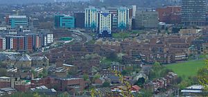
This big change was part of a plan to rebuild a large area (48.5 hectares). The City Architect, J. L. Womersley, led the project. St Annes Church on Hoyle Street was also pulled down later. New homes were built between 1959 and 1972. These were mostly tall tower blocks and three or four-story maisonettes. Maisonettes are like apartments spread over two floors.
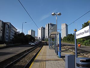
The tall tower blocks were placed near open spaces. The lower buildings were grouped to create connected courtyards with walking paths. Smaller flats were made in the lower buildings for older people. This helped them live near their grown-up families. Four tower blocks were finished in 1962. They were named Adamfield, Cornhill, Robertshaw, and Crawshaw. Two blocks have 14 floors, and two have 12 floors. In 1998, they were updated and given a new blue and cream look. Some maisonettes were later replaced with regular houses in the early 2000s.
When the old houses were demolished, a park called The Ponderosa was created. It's a recreation area for people in Netherthorpe and Upperthorpe.
Important Buildings
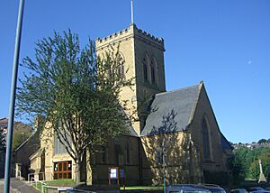
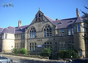
Netherthorpe has only three buildings from the 1800s. Two of them are special and are called Grade II listed buildings. These are St Stephen's Church and Netherthorpe Primary School.
St Stephen's Church on Fawcett Street was built in 1856. In the 1950s, the church was too big for the number of people attending. So, a wall was built inside to make a smaller worship area. The rest became a community hall for everyone to use.
Netherthorpe Primary School on Netherthorpe Street was built in 1873. It teaches children from ages three to eleven. The school also has a modern sports hall on Dover Street.
Another school in the area is Bethany School on Finlay Street. It teaches students from ages four to 16. This is a Christian Family School that has been in Netherthorpe since 2001. The building itself is older, opening as St Stephen's Primary School in 1860. It was empty for a while before Bethany School moved in.
Newer Changes
One of the biggest new things in Netherthorpe is the Sheffield Supertram. This light rail system started in 1995. It gives the area great transport links. Netherthorpe has its own tram stop on Netherthorpe Road. It's in the middle of the dual carriageway. You get to it through an underground path. This path has barriers that can make it hard for bikes or mobility aids to pass through.
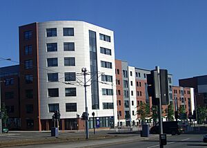
Netherthorpe is very close to Sheffield University. Because of this, many students live in the area. In 2009, a large building called Opal 3 was built on Hoyle Street. It has rooms for 992 students. It also has fun facilities and access for people with disabilities. Inside Opal 3 is the English Language Teaching Centre. This is part of Sheffield University and helps students who need help with English.
Other Local Spots
There are no doctor's offices (GP practices) right in Netherthorpe. The closest ones are in Upperthorpe and on Broad Lane. There is one pub in the area called the White Hart on St Philips Road. It's a traditional pub for local residents.
For shopping, there's a Sainsbury's Local at the top of Weston Street. There's also a big Tesco store. This Tesco is technically in Upperthorpe. An important building that might be missed is the Medico-Legal Centre on Watery Street. This building helps with investigations when someone dies suddenly or unexpectedly. It includes offices for the Coroner and a public mortuary.
Facts and Figures
Netherthorpe has about 3,000 people living there. In 2003, the official number was 2,925. The area has more people from different backgrounds than the average for Sheffield. Many people of mixed race, Asian, Black, and Chinese heritage live here. This is partly because many students live in the area.
Most people in Netherthorpe live in flats, maisonettes, or apartments (75%). This is much higher than the Sheffield average of 18%. Also, 65% of homes in Netherthorpe are rented from the local authority. Only 15% of people own their homes.


