New Berlin, New York facts for kids
Quick facts for kids
New Berlin, New York
|
|
|---|---|

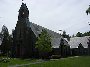
St. Andrew's Episcopal Church, New Berlin
|
|
 |
|
| Country | United States |
| State | New York |
| County | Chenango |
| Government | |
| • Type | Town Council |
| Area | |
| • Total | 46.57 sq mi (120.62 km2) |
| • Land | 46.13 sq mi (119.49 km2) |
| • Water | 0.44 sq mi (1.14 km2) |
| Elevation | 1,320 ft (400 m) |
| Population
(2010)
|
|
| • Total | 2,682 |
| • Estimate
(2016)
|
2,510 |
| • Density | 55.10/sq mi (21.27/km2) |
| Time zone | Eastern (EST) |
| ZIP code |
13411
|
| FIPS code | 36-017-49957 |
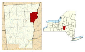
New Berlin is a town located in the middle of New York State, in Chenango County. In 2010, about 2,682 people lived there. The town also includes the village of New Berlin. It's on the eastern edge of Chenango County, northeast of a city called Norwich.
Contents
History of New Berlin
The first European settlers came to New Berlin around 1790, right after the American Revolutionary War. Before this, the Iroquois League nations, who had lived on this land for a long time, had to give up most of their territory. This happened after their ally, Great Britain, lost the war. Many Mohawk and other Iroquois nations moved to Ontario, Canada. The British Crown gave them some land there. Some smaller areas were set aside for them in New York State.
The Town of New Berlin was created in 1807. It was formed from a part of the Town of Norwich. The town was named after Berlin, Germany, because many new settlers came from there. In 1821, the town's name changed to "Lancaster," but it went back to "New Berlin" the very next year. In 1853, a part of New Berlin was used to create the Town of Sherburne.
Geography of the Town
New Berlin covers a total area of about 120.6 square kilometers (46.6 square miles). Most of this area is land, about 119.5 square kilometers (46.1 square miles). Only a small part, about 1.1 square kilometers (0.44 square miles), is water.
The eastern border of the town is formed by the Unadilla River. This river also marks the boundary with Otsego County. The Unadilla River flows south and is a branch of the Susquehanna River.
Several important roads pass through New Berlin. New York State Route 8 runs north and south. It crosses New York State Route 80 near New Berlin village at a spot called Five Corners. New York State Route 23 is another road that runs east and west, starting from Norwich.
Population and People
| Historical population | |||
|---|---|---|---|
| Census | Pop. | %± | |
| 1820 | 2,366 | — | |
| 1830 | 2,643 | 11.7% | |
| 1840 | 3,086 | 16.8% | |
| 1850 | 2,562 | −17.0% | |
| 1860 | 2,617 | 2.1% | |
| 1870 | 2,460 | −6.0% | |
| 1880 | 2,572 | 4.6% | |
| 1890 | 2,427 | −5.6% | |
| 1900 | 2,525 | 4.0% | |
| 1910 | 2,328 | −7.8% | |
| 1920 | 2,104 | −9.6% | |
| 1930 | 2,123 | 0.9% | |
| 1940 | 2,112 | −0.5% | |
| 1950 | 2,359 | 11.7% | |
| 1960 | 2,633 | 11.6% | |
| 1970 | 2,823 | 7.2% | |
| 1980 | 3,025 | 7.2% | |
| 1990 | 3,046 | 0.7% | |
| 2000 | 2,803 | −8.0% | |
| 2010 | 2,682 | −4.3% | |
| 2019 (est.) | 2,510 | −6.4% | |
| U.S. Decennial Census | |||
According to the census from 2000, there were 2,803 people living in New Berlin. These people lived in 1,083 households, and 737 of these were families. The population density was about 60 people per square mile.
Most people in the town were White (98.14%). A small number were Black or African American (0.36%), Native American (0.14%), or Asian (0.14%). About 1.21% of the population was Hispanic or Latino.
About 32% of households had children under 18 living with them. More than half (55.3%) were married couples. The average household had 2.51 people, and the average family had 2.96 people.
The median age in the town was 40 years old. This means half the people were younger than 40, and half were older. About 25.6% of the population was under 18.
Communities and Places
New Berlin has several smaller communities and interesting places within its borders:
- Amblerville – A small community northwest of South New Berlin.
- Chenango Lake – A community in the western part of the town, next to a lake with the same name.
- Davis Crossing – A community south of New Berlin village on Route 8.
- Five Corners – A small community in the northeastern part of the town, north of New Berlin village.
- Holmesville – A community at the very southern tip of the town, south of South New Berlin on Route 8.
- Hunts Pond State Park – This used to be a state park. Since 2011, it has been managed as part of Hunts Pond State Forest.
- New Berlin – This is the main village, located in the northeastern part of the town on Route 8. The Unadilla River forms its eastern border.
- Mill Brook Reservoir – A lake located west of the village of New Berlin.
- Sages Crossing – A community near the eastern town line on Route 8.
- South New Berlin – A community near the southern end of the town on Route 8.
Notable People from New Berlin
- Helen A. Manville – A poet and writer.
- Anson Burlingame – A lawyer, congressman, and diplomat. He was also against slavery.
Education
- Unadilla Valley Central School – This school serves students in the New Berlin area.
See also
 In Spanish: New Berlin (Nueva York) para niños


