New Utrecht, Brooklyn facts for kids
New Utrecht (also called Nieuw Utrecht in Dutch) was an old town in what is now Brooklyn, New York City. It was located on the western part of Long Island. Today, parts of New Utrecht are known as Bath Beach, Bay Ridge, Bensonhurst, Borough Park, Dyker Heights, and Fort Hamilton.
Dutch settlers from the Netherlands created New Utrecht in 1652. It was part of the Dutch colony called New Netherland. New Utrecht was the last of the original six towns founded in Kings County. The town of New Utrecht stopped existing in 1894. At that time, it became part of the City of Brooklyn. Later, in 1898, Brooklyn joined the City of Greater New York, and New Utrecht became part of a borough of New York City.
Contents
History of New Utrecht
How the Dutch Settled the Area
In 1643, a man named Anthony Janszoon van Salee got a large piece of land on western Long Island. This land was mostly empty until 1652. That's when Cornelius van Werckhoven took it over. Werckhoven was a surveyor and an important investor in the Dutch West India Company. He was born in Utrecht in the Netherlands.
After Werckhoven died in 1655, his children's guardian, Jacques Cortelyou, was allowed to sell parts of the land. He created twenty lots to build a new town. Cortelyou named this new settlement Nieuw Utrecht, honoring Werckhoven's hometown.
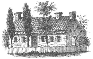
Nicasius de Sille, a lawyer from the Netherlands, was one of the first people to buy a lot. He built a house using local stone. Its roof had red tiles brought all the way from the Netherlands. De Sille moved to New Utrecht from New Amsterdam (which is now part of Manhattan). He was an advisor to Governor Peter Stuyvesant.
Once a protective wall was built around New Utrecht, more people moved there. In 1657, New Utrecht became a village. In 1661, Governor Stuyvesant gave New Utrecht its own official charter. In 1664, the English took over New Netherland. They changed its name to the Province of New York.
Some of the first Dutch families in New Utrecht were the Bensons, di Sille, Van Pelt, Cropsey, and Nostrand families. Today, streets in Brooklyn like Cropsey Avenue and Nostrand Avenue are named after some of these founding families.
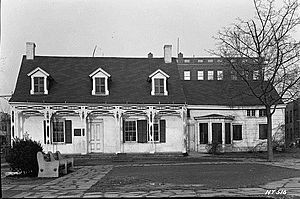
The Van Pelt Manor House was built over time. The first stone part was built around 1675. It was later made bigger, and a second floor was added around 1686.
New Utrecht Church and Cemetery

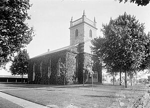
At first, people in New Utrecht traveled to Flatbush for church services. But they created the New Utrecht Cemetery in 1654. In 1677, they officially started the New Utrecht Reformed Church for their own community. They built their first church in 1700. The second church, which is still standing today, was built in the 1830s. It used bricks from the first church building.
Both the church and the cemetery are very important historical sites. They have been named National Historic Landmarks. In 1856, a serious illness called yellow fever spread to nearby areas like Bay Ridge and Fort Hamilton. The New Utrecht Cemetery has a monument from 1910. It honors Dr. James E. DuBois and Dr. John L. Crane, who died while helping people during the outbreak.
New Utrecht in Kings County
In 1683, the English created Kings County within the Province of New York. New Utrecht was one of the six original towns in this county. It included the smaller villages of New Utrecht, Bath, Fort Hamilton, and Bay Ridge. Town records were kept in Dutch until 1763. After that, the British required all records to be in English.
New Utrecht During the American Revolution
During the American Revolution, the British Army used New Utrecht as their main base. This was especially true during the Battle of Long Island in August 1776. General Howe, the British commander, set up his headquarters in an old mansion there.
The American General Nathaniel Woodhull was badly hurt in battle. The British took him to the Nicasius di Sille house for treatment. This house was later taken down in 1850.
The area where Fort Hamilton was built later (in the 1820s) was home to several houses. During the British attack on August 26, 1776, these houses were hit by cannon fire from British ships. From 1776 until the British left, American supporters secretly crossed The Narrows by fishing boat at night. They met with other American patriots in Staten Island and New Jersey.
During the War of 1812, the U.S. Army started building a fort called Fort Diamond. It was on an island near what is now Bay Ridge. In 1825, it was renamed Fort Lafayette to honor the Marquis de La Fayette, a French hero of the American Revolution. This fort was taken down in 1960 to make way for the Verrazano-Narrows Bridge. The bridge's pillars on the Brooklyn side now stand where the fort used to be.
In 1894, a group called the "Winter Society" started the Free Library of the Town of New Utrecht.
New Utrecht officially became part of the City of Brooklyn on July 1, 1894. Then, on January 1, 1898, it joined the larger City of New York.
New Utrecht Today
The original center of New Utrecht is now located in the Bensonhurst neighborhood of Brooklyn. Eighty-fourth Street, between Sixteenth and Eighteenth avenues, is close to where the town's main road used to be.
Other parts of the old town are now the neighborhoods of Borough Park and Bay Ridge. Borough Park is known for its large Hasidic Jewish community. Bay Ridge was once called Yellow Hook. Its name was changed after several outbreaks of yellow fever in the New York area during the 1800s.
See also
 In Spanish: New Utrecht (Brooklyn) para niños
 | Emma Amos |
 | Edward Mitchell Bannister |
 | Larry D. Alexander |
 | Ernie Barnes |


