North Harmony, New York facts for kids
Quick facts for kids
North Harmony, New York
|
|
|---|---|

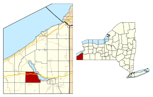
Location within Chautauqua County and New York
|
|
| Country | United States |
| State | New York |
| County | Chautauqua |
| Government | |
| • Type | Town Council |
| Area | |
| • Total | 42.16 sq mi (109.18 km2) |
| • Land | 42.13 sq mi (109.12 km2) |
| • Water | 0.02 sq mi (0.06 km2) |
| Elevation | 1,473 ft (449 m) |
| Population
(2020)
|
|
| • Total | 2,182 |
| • Estimate
(2021)
|
2,172 |
| • Density | 52.17/sq mi (20.14/km2) |
| Time zone | UTC-5 (Eastern (EST)) |
| • Summer (DST) | UTC-4 (EDT) |
| FIPS code | 36-013-52155 |
| GNIS feature ID | 0979288 |
North Harmony is a town in Chautauqua County, New York, United States. It is located on the west side of Chautauqua Lake. Many summer resort communities are found along the lake's shore in this area. In 2020, about 2,182 people lived in North Harmony.
Contents
History of North Harmony
The town of North Harmony was created on December 19, 1918. It was formed from a part of the nearby town of Harmony.
Exploring North Harmony's Geography
North Harmony covers a total area of about 109.2 square kilometers (or 42.2 square miles). Only a very small part of this area, about 0.06 square kilometers, is water.
Important roads pass through the town. The Southern Tier Expressway, which includes Interstate 86 and New York State Route 17, runs through North Harmony. New York State Route 394 follows the western shore of Chautauqua Lake. Also, New York State Route 474 crosses the southeastern part of the town.
What Towns Border North Harmony?
North Harmony shares its borders with several other towns.
- The eastern side of North Harmony is along Chautauqua Lake.
- To the north, you'll find the town of Chautauqua.
- The western border is next to the town of Sherman.
- To the south are the towns of Clymer and Harmony.
- North Harmony also has a small border on its southeast corner with the town of Busti.
Who Lives in North Harmony?
| Historical population | |||
|---|---|---|---|
| Census | Pop. | %± | |
| 1920 | 1,235 | — | |
| 1930 | 1,462 | 18.4% | |
| 1940 | 1,453 | −0.6% | |
| 1950 | 1,675 | 15.3% | |
| 1960 | 2,132 | 27.3% | |
| 1970 | 2,264 | 6.2% | |
| 1980 | 2,263 | 0.0% | |
| 1990 | 2,301 | 1.7% | |
| 2000 | 2,521 | 9.6% | |
| 2010 | 2,267 | −10.1% | |
| 2020 | 2,182 | −3.7% | |
| 2021 (est.) | 2,172 | −4.2% | |
| U.S. Decennial Census | |||
According to the census from 2000, there were 2,521 people living in North Harmony. These people lived in 927 households, and 724 of those were families.
Most of the people in the town were White (98.85%). A small number of people were from other racial backgrounds. About 0.79% of the population identified as Hispanic or Latino.
About 35.3% of the households had children under 18 living with them. Most households (67.1%) were married couples living together. The average household had about 2.72 people.
The population was spread out by age. About 27.3% of the people were under 18 years old. About 12.3% were 65 years or older. The average age in the town was 39 years.
Communities and Places in North Harmony
North Harmony is home to several smaller communities and interesting spots:
- Ashville – A small village located in the southeast part of the town, along NY Route 474.
- Bly Bay – A bay on the west side of Chautauqua Lake, found south of Cheney's Point.
- Cheney's Point – A lakeside village located on a piece of land sticking out into the lake, south of Hadley Bay.
- Connelly Park – Another lakeside village, also south of Hadley Bay.
- Elm Tree – A village where the Southern Tier Expressway meets County Road 33.
- Hadley Bay – A lakeside village located south of the Southern Tier Expressway.
- Long View – A lakeside village south of Cheney's Point.
- Niets Crest – A village located south of Longview.
- Quigley Park – A village found near Cheney's Point.
- Stebbins Corners – A village on the town's northwest border, where County Roads 18 and 25 meet.
- Stedman – A village near the northern town line, at the meeting point of County Roads 18 and 33.
- Stow – A popular lakeside village and resort area north of the Southern Tier Expressway.
- Toms Point – A piece of land that sticks out into Lake Chautauqua, close to Stow.
- Victoria – A village located north of Stow.
- Vukote – A village where NY Route 474 ends at NY Route 394.
- Warner Bay – A bay on the west side of Chautauqua Lake, south of Long View.
- Woodlawn – A village located north of Stow.
See also
 In Spanish: North Harmony (Nueva York) para niños
 | Emma Amos |
 | Edward Mitchell Bannister |
 | Larry D. Alexander |
 | Ernie Barnes |


