Norwood, Missouri facts for kids
Quick facts for kids
Norwood, Missouri
|
|
|---|---|

Norwood
|
|

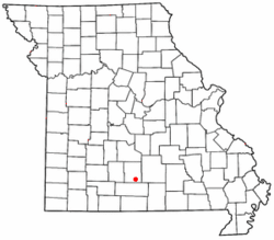
Location of Norwood, Missouri
|
|
| Country | United States |
| State | Missouri |
| County | Wright |
| Area | |
| • Total | 1.60 sq mi (4.15 km2) |
| • Land | 1.60 sq mi (4.15 km2) |
| • Water | 0.00 sq mi (0.00 km2) |
| Elevation | 1,489 ft (454 m) |
| Population
(2020)
|
|
| • Total | 578 |
| • Density | 361.02/sq mi (139.37/km2) |
| Time zone | UTC-6 (Central (CST)) |
| • Summer (DST) | UTC-5 (CDT) |
| ZIP code |
65717
|
| Area code(s) | 417 |
| FIPS code | 29-53454 |
| GNIS feature ID | 0723525 |
Norwood is a small city located in Wright County, Missouri, in the United States. In 2010, about 665 people lived there.
Contents
History of Norwood
Norwood was started in 1882. A lawyer named W.S. Thompson gave the community its name. He was inspired by a book called Norwood: or, Village Life in New England, written by Henry Ward Beecher. A post office has been open in Norwood since 1882, helping people send and receive mail.
Geography and Location
Norwood is found in the Ozarks, which is a highland area. It sits on the southern edge of a part of the Ozarks called the Salem Plateau.
Several roads serve the community, including US Route 60 and Routes C, PP, and E. If you travel east on Route 60, you will reach Mountain Grove. If you go west, you will find Mansfield.
The town is located on a drainage divide. This means that rain falling to the south of Norwood flows into rivers that are part of the White River system. Rain falling to the north flows into rivers that are part of the Missouri River system.
The United States Census Bureau says that Norwood covers a total area of about 1.60 square miles (4.15 square kilometers). All of this area is land.
Population and People
| Historical population | |||
|---|---|---|---|
| Census | Pop. | %± | |
| 1930 | 349 | — | |
| 1940 | 398 | 14.0% | |
| 1950 | 345 | −13.3% | |
| 1960 | 263 | −23.8% | |
| 1970 | 294 | 11.8% | |
| 1980 | 391 | 33.0% | |
| 1990 | 449 | 14.8% | |
| 2000 | 552 | 22.9% | |
| 2010 | 665 | 20.5% | |
| 2020 | 578 | −13.1% | |
| U.S. Decennial Census | |||
Norwood's Population in 2010
According to the census taken in 2010, there were 665 people living in Norwood. These people lived in 241 different homes, and 167 of these were families. The population density was about 415.6 people for every square mile (160.5 people per square kilometer). There were 277 houses or apartments in total.
Most of the people in Norwood were White (96.1%). A small number were African American (0.9%) or Native American (0.9%). About 1.4% of the population identified as Hispanic or Latino.
In 2010, 43.6% of homes had children under 18 living there. About 48.5% of homes were married couples living together. The average home had about 2.76 people, and the average family had about 3.26 people.
The average age of people in Norwood was 31.9 years old. About 31.9% of the residents were under 18. Also, 9.8% of the people were 65 years old or older. Slightly more than half of the population (51.7%) was male, and 48.3% was female.
Education in Norwood
Public schools in Norwood are managed by the Norwood R-I School District.
See also
 In Spanish: Norwood (Misuri) para niños
 | Madam C. J. Walker |
 | Janet Emerson Bashen |
 | Annie Turnbo Malone |
 | Maggie L. Walker |

