Nuthurst facts for kids
Quick facts for kids Nuthurst |
|
|---|---|
 Sedgwick Park |
|
| Area | 16.97 km2 (6.55 sq mi) |
| Population | 1,711 2001 Census 1,777 (civil parish 2011) |
| • Density | 101/km2 (260/sq mi) |
| OS grid reference | TQ192261 |
| • London | 34 miles (55 km) NNE |
| Civil parish |
|
| District |
|
| Shire county | |
| Region | |
| Country | England |
| Sovereign state | United Kingdom |
| Post town | HORSHAM |
| Postcode district | RH13 |
| Dialling code | 01403 |
| Police | Sussex |
| Fire | West Sussex |
| Ambulance | South East Coast |
| EU Parliament | South East England |
| UK Parliament |
|
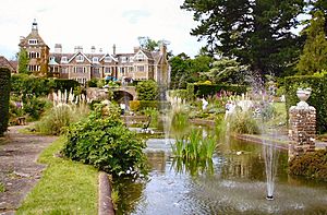
Nuthurst is a village and civil parish in West Sussex, England. It is located in the Horsham district. The northern part of the parish is next to Horsham town. Nuthurst village itself is about 3 miles (5 km) south of the Horsham border. Inside the parish, you'll find the Sedgwick Park estate. This estate includes a large country house, mostly built in the 1800s.
Contents
A Look Back: Nuthurst's History
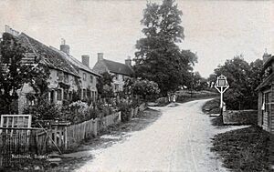
Nuthurst isn't mentioned in the famous Domesday Book. This book was a huge survey of England made in 1086. The name 'Nothurst' first appeared in records in 1228. It means "wooded hill where nut-trees grow". This name comes from old English words.
Life in Nuthurst: 1800s Occupations
In 1855, Nuthurst parish covered about 3,460 acres (14 km²). The population was 768 in 1841 and 727 in 1851. Many people worked as farmers. There were also charcoal burners, carpenters, and blacksmiths. Other jobs included shoemakers, bakers, and shopkeepers. Some shopkeepers also ran the local post office. There were also wheelwrights, who made and repaired wheels. The village had two inns: The Black Horse Inn and The Dun Horse Inn. A miller worked at Nuthurst Mill.
Nuthurst Mill: From Iron to Corn
Nuthurst Mill, also known as Bircham Mill, was a watermill on the River Arun. It was located at the northern edge of the parish. Before 1715, this mill was an iron forge. It used power from a large lake created by damming the Arun. This iron forge was active in the 1500s and 1600s. People even dug for iron ore in the parish.
Around 1715, Nuthurst Mill changed. It became a watermill for grinding corn. It was still working in 1937, though not by water power. The mill became old and unused soon after. Its remains were taken down after 1956. Another watermill in Copsale was on an 1840s map. It stopped working by 1896 and was demolished.
Growing Community: Schools and Churches
By 1861, the population of Nuthurst was 767. The parish helped people in need through the Horsham Union. This group was formed in 1835 to help ten parishes.
In 1866, jobs included farmers, blacksmiths, and wheelwrights. There were also bakers, shopkeepers, and shoemakers. The Black Horse and Dun Horse inns were still open. St Andrew's parish church was made bigger in 1856. This cost £2,400. Money came from the church leader, local people, and a society that helped build churches. A new house for the church leader was built in 1859. There was also a National School for boys and girls. Church records for the parish go back to 1535.
Changes in the Late 1800s
By 1878, the land in Nuthurst was a mix of clay and sand. Farmers mainly grew wheat, oats, peas, and root vegetables. The population had dropped to 699 by 1871. Jobs included farmers, shopkeepers, carpenters, and bootmakers. The miller at Bircham Bridge was still working. The parish now had three pubs. These were The Black Horse, The Dun Horse, and The White Horse Inn at Maplehurst.
A Wesleyan chapel was built in Mannings Heath in 1869. By 1878, a small church called a chapel of ease was built in Copsale. This church was made of brick.
By 1890, the parish area had grown. The population also increased to 811 by 1881. Jobs included farmers, farm managers, and wheelwrights. There were also bootmakers, wood dealers, and shopkeepers. The Birchen Bridge miller was still active. The three inns – The Black Horse, White Horse, and Dun Horse – were still popular. The Dun Horse even offered rooms for cyclists.
In 1890, the local church was part of the Diocese of Chichester. St Andrew's Church could seat 400 people. The Copsale Chapel of Ease could seat 115. Another chapel, the Mission church of the Good Shepherd, was built in 1881. A new National School for children was built in Mannings Heath in 1863.
Nuthurst at the Turn of the Century
Around 1900, Nuthurst parish covered about 3,489 acres (14 km²) of land. The population in 1891 was 853. In 1877, a small area called Little Broadwater joined the parish.
In 1899, jobs included gardeners, bootmakers, and farm managers. There were 16 farmers. Some farmers specialized in poultry and dairy. A builder worked at Monks Gate. In Maplehurst, there was a combined grocer, baker, and meat salesman. The Birchen Bridge miller was still working. Mannings Heath had a stone merchant, a post office, and a gamekeeper. The White, Black, and Dun Horse inns were still serving customers.
St Andrew's Church in Nuthurst village was made bigger in 1898. During this work, a very old Norman window was found. A new house for the church's assistant priest was built in Mannings Heath in 1894. A Congregational chapel also joined the other churches in Mannings Heath. The National School in Nuthurst was made bigger in 1894 to hold 160 children. The Mannings Heath National School was enlarged in 1874 for 100 children.
Nuthurst in the Early 1900s
By 1915, the land area of Nuthurst was similar. However, the population had decreased by 1911. It was 757 in the civil parish and 731 in the church parish.
Fourteen farms were still operating. The miller at Birchen Bridge was still working. The publicans at the White, Black, and Dun Horse inns were still there. A bootmaker ran the Post Office. A plumber was in Mannings Heath, and a builder was at Monks Gate. There was a blacksmith, a wheelwright, and a grocer in Maplehurst. A new Parish Hall was built in Mannings Heath in 1901.
Nuthurst's Location and People
Nuthurst parish is about 35 miles (56 km) south of London. It is also about 25 miles (40 km) north-east of Chichester, the county town. The parish is in the northern and eastern part of the Horsham district in West Sussex.
The total land area of the parish is 4,191 acres (1,697 hectares). Most of the parish is countryside and farmland. There are six main settlements and scattered homes. The main village is Nuthurst, in the center. Mannings Heath is the largest village, located in the north-east. It's a place where people live and travel to Horsham for work.
Other smaller areas include Monk's Gate, Copsale, Maplehurst, and Sedgwick. The only major road is the A281, which goes from Horsham to Brighton. This road passes through Mannings Heath.
Nuthurst is next to several other parishes. These include Horsham to the north and Lower Beeding to the east. The River Arun forms the northern border between Nuthurst and Horsham.
In the 2001 census, 1,711 people lived in Nuthurst. They lived in 702 households. In the 2011 Census, the population grew slightly to 1,777 people.
Community Life in Nuthurst
Nuthurst parish is managed by a parish council. This council helps make decisions for the local community.
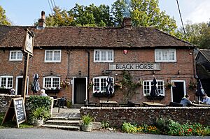
The parish has two public houses (pubs). These are the Black Horse Inn in Nuthurst village and the White Horse Inn in Maplehurst. The Dun Horse Inn in Mannings Heath is now closed. Mannings Heath has a village store, a delicatessen, and a garage for car services.
There are two churches in the parish. One is the Church of England parish church of St Andrew's in Nuthurst village. It has a nearby school called St Andrew's C of E–aided school. The other church is the Church of the Good Shepherd in Mannings Heath.
The parish also has two village halls. One is in Copsale and the other in Mannings Heath. The local cricket team, Nuthurst CC, plays at Mannings Heath common. Mannings Heath Golf Club & Wine Estate is also located in the north-east of the parish.
A well-known landmark in Nuthurst is Sedgwick Park. It's about 2 miles (3 km) south of Horsham. The house was mostly built in the 1800s. However, one part might be from as early as 1608. In the park's grounds, you can find small remains of the medieval Sedgwick Castle. It used to be surrounded by a moat, which is now mostly dry.
 | Kyle Baker |
 | Joseph Yoakum |
 | Laura Wheeler Waring |
 | Henry Ossawa Tanner |


