Irving Park, Chicago facts for kids
Quick facts for kids
Irving Park
|
|
|---|---|
| Community Area 16 - Irving Park | |

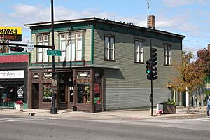
The Whistle Stop Inn, a Chicago Landmark
|
|

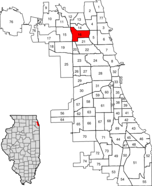
Location within the city of Chicago
|
|
| Country | United States |
| State | Illinois |
| County | Cook |
| City | Chicago |
| Neighborhoods | |
| Area | |
| • Total | 3.23 sq mi (8.37 km2) |
| Population
(2020)
|
|
| • Total | 51,940 |
| • Density | 16,072/sq mi (6,205/km2) |
| Demographics 2018 | |
| • White | 42.93% |
| • Black | 3.04% |
| • Hispanic | 42.19% |
| • Asian | 8.23% |
| • Other | 3.60% |
| Time zone | UTC-6 (CST) |
| • Summer (DST) | UTC-5 (CDT) |
| ZIP Codes |
parts of 60618, 60630, 60641
|
| Median household income 2018 | $64,598 |
| Source: U.S. Census, Record Information Services | |
Irving Park is one of Chicago's 77 official community areas. It is located on the city's Northwest Side. The area is bordered by the Chicago River to the east and railroad tracks to the west. It stretches from Addison Street in the south to Montrose Avenue in the north. The community is named after the famous American author Washington Irving.
The neighborhood of Old Irving Park has many different types of homes. You can find Queen Anne, Victorian, and Italianate houses. There are also old farmhouses and many bungalows.
The CTA Blue Line train runs through Irving Park. It has stops at Addison, Irving Park, and Montrose stations.
Contents
History of Irving Park
How Irving Park Began
Irving Park started to develop in 1843. Major Noble bought a large piece of land, about 160 acres, and started a farm. His house also served as a tavern called the Buckthorn Tavern. It was a stop for travelers going to and from Chicago.
In 1869, four men from New York bought Noble's farm. They also bought more land nearby. At first, they planned to continue farming. But they saw how well other suburban communities were growing. So, they decided to divide their land into plots and create a new, special settlement. It was about 7 miles from the city.
The developers made a deal with the Chicago and Northwestern Railroad. The trains would stop in Irving Park if the developers built a station. They did, and that station is still used today! The original name for the new suburb was "Irvington," after author Washington Irving. But another town in Illinois already had that name. So, they chose "Irving Park" instead.
Many early homes were built between 1870 and 1874. The Great Chicago Fire of 1871 brought new people to the area. They built unique homes, though a bit simpler than the first mansions.
The first church in Irving Park was built in 1872. It was the Dutch Reformed Church. For 13 years, it was the only place of worship. By the early 1900s, many other churches had been built. These included Episcopalian, Methodist, Disciples of Christ, Catholic, and Baptist congregations.
Joining the City of Chicago
By the 1880s, people in Irving Park started to miss some of the benefits of living in the city. In 1889, Irving Park and the surrounding area joined Chicago. This brought many improvements. Water was piped in from Lake Michigan, a fire department was established, and streetcar service started on major streets.
Over 200 homes were built in the first 20 years. Several new areas were added to Irving Park. One of these was Grayland, which opened in 1874. It grew around the Milwaukee Road Railroad station, which is still in use. The oldest house in Irving Park, built in 1856, is in Grayland.
Other areas developed east of Pulaski Road in the late 1890s. West Walker has large single-family homes. The Villa District, also known as the "Villa addition to Irving Park," has many unique Craftsman and Bungalow style homes. The Villa District is now a Chicago Landmark district.
In 1910, Irving Park residents created their own park district. They built eight local parks, with Independence Park being the largest. Independence Park was known for its beautiful landscaping. It also hosted annual 4th of July celebrations. These events included a parade, athletic games, a band concert, and fireworks. In 1933, the Irving Park District joined the Chicago Park District.
Irving Park continued to grow in the early 1900s. Many large apartment buildings were built, especially north of Irving Park Boulevard. These buildings often had fancy wrought-iron fences and terra cotta details. During the Great Depression and World War II, many larger homes were turned into rooming houses. Later, the construction of the Northwest Expressway (Kennedy) cut through the heart of Irving Park. This caused many residents to move and many homes and businesses to be lost.
Irving Park Today
In the early 1980s, Irving Park saw a new beginning. More people discovered its beautiful homes and rich history. The Irving Park Historical Society was formed in 1984. Its goal is to help protect the neighborhood's heritage and its unique old buildings. Since then, many homes have been restored. Volunteers have found hundreds of buildings that are still in use from before 1894. Many of these date back to the 1870s.
Serbian Community
In the 1990s, many Serbian immigrants moved to Irving Park. Today, you can find many Serbian-owned cafes and restaurants along Irving Park Road. As of 2015, about 2,650 Serbian families lived in Irving Park. The total number of Serbians in the neighborhood is over 3,000.
Population Changes in Irving Park
| Historical population | |||
|---|---|---|---|
| Census | Pop. | %± | |
| 1930 | 66,783 | — | |
| 1940 | 66,553 | −0.3% | |
| 1950 | 64,881 | −2.5% | |
| 1960 | 58,298 | −10.1% | |
| 1970 | 54,883 | −5.9% | |
| 1980 | 49,489 | −9.8% | |
| 1990 | 50,159 | 1.4% | |
| 2000 | 58,643 | 16.9% | |
| 2010 | 53,359 | −9.0% | |
| 2020 | 51,940 | −2.7% | |
| U.S. Decennial Census | |||
Neighborhoods of Irving Park
Old Irving Park
'Old Irving Park' is also known as 'Grayland'. It is the historical center of the Irving Park Community Area. Its borders are Montrose to the north, Addison to the south, Pulaski Road to the east, and Cicero to the west. These are the same borders as the original farms that started the area in the 1870s.
The Villa
The Villa district was built in 1902. Many architects designed homes here, and they were often influenced by Frank Lloyd Wright's Prairie Style of architecture. This area was originally called the "Villa addition to Irving Park." It has many unique Craftsman and Prairie style homes on pretty, boulevard-style streets. The historic St. Wenceslaus church is a few blocks south of this district.
Independence Park
'Independence Park' is a neighborhood within Irving Park. It was developed in the 1800s and shares its name with a local park. Its borders are Irving Park Road to the north, the Kennedy Expressway to the west, Elston Avenue and Central Park Avenue to the east, and Addison Street to the south.
West Walker
'West Walker' is an area bordered by Irving Park Road to the south, Central Park Avenue to the east, Montrose Avenue to the north, and Pulaski Street to the west. Inside West Walker is the 'West Walker Triangle'. This smaller area is bordered by Irving Park Road to the south, Pulaski Road to the west, and Elston Avenue to the northeast.
California Park
'California Park' is a neighborhood in the eastern part of Irving Park. It started developing in the 1920s. It has simple single-family homes and many family-owned businesses. Its borders are Montrose Avenue to the north, Addison Street to the south, Kedzie Avenue to the west, and the Chicago River to the east.
Kilbourn Park
Kilbourn Park is mainly a middle-class residential and industrial area. It is bordered by Milwaukee to the north, Belmont to the south, the Union Pacific/Northwest rail line to the east, and Cicero to the west. Even though it's part of Irving Park, it's more similar to the neighboring area of Avondale.
Avondale Gardens (Merchant Park)
Avondale Gardens, also known as Merchant Park, is bordered by Addison to the north, Belmont to the south, the Union Pacific/Northwest rail line to the west, and Pulaski Road to the east. Some people recently started calling it "South Old Irving Park." Like Kilbourn Park, this neighborhood is more like Avondale than other parts of Irving Park. The name Merchant Park comes from John and Clara Merchant, whose house in Old Irving is an official landmark in Chicago.
Little Cassubia
Little Cassubia was a historical neighborhood in the Irving Park Community Area. It was located between Irving Park on the north, Addison to the south, Kimball to the west, and Kedzie to the east. Locals gave it the name "Little Cassubia" because many Kaszub people lived there. They also founded the Roman Catholic Parish of Immaculate Heart of Mary.
Education in Irving Park
Chicago Public Schools manages the public schools in the Irving Park area. The Kedvale campus of Disney II Magnet School is located in the Old Irving Park neighborhood. Chicago Jewish Day School is also in this community area.
Famous People from Irving Park
- Aimee Garcia (born 1978): An actress known for shows like The George Lopez Show and Lucifer. She spent part of her childhood in Irving Park.
- John Nuveen (1864–1948): He founded The John Nuveen Co., which helped fund important projects like Wacker Drive and Grant Park. He lived in Irving Park when he was in his twenties.
- Frank Piatek (born 1944): An artist and educator who was born and grew up in Irving Park.
- Chuck Nergard (1929–2017): A politician who served in the Florida House of Representatives. He lived in Irving Park during the 1940s and 1950s.
- Jeff Tweedy (born 1967): A songwriter, musician, and record producer. He is best known as the singer and guitarist for the band Wilco. He has been a resident of Irving Park since 2019.

