Ozark, Alabama facts for kids
Quick facts for kids
Ozark
|
|||
|---|---|---|---|
|
|||

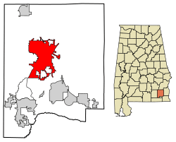
Location of Ozark in Dale County, Alabama.
|
|||
| Country | United States | ||
| State | Alabama | ||
| County | Dale | ||
| Settled | 1822 | ||
| Incorporated | October 27, 1870 | ||
| Government | |||
| • Type | Mayor/City Council | ||
| Area | |||
| • Total | 34.34 sq mi (88.94 km2) | ||
| • Land | 34.10 sq mi (88.33 km2) | ||
| • Water | 0.23 sq mi (0.61 km2) | ||
| Elevation | 417 ft (127 m) | ||
| Population
(2020)
|
|||
| • Total | 14,368 | ||
| • Density | 421.30/sq mi (162.66/km2) | ||
| Time zone | UTC-6 (Central (CST)) | ||
| • Summer (DST) | UTC-5 (CDT) | ||
| ZIP Codes |
36360–36361
|
||
| Area code(s) | 334 | ||
| FIPS code | 01-57648 | ||
| GNIS feature ID | 0152832 | ||
Ozark is a city in Alabama, United States. It is the main city and the county seat of Dale County. This means it is where the county government is located.
In 2010, about 14,907 people lived in Ozark. The city is also a key part of the Ozark Micropolitan Statistical Area. It is near Fort Novosel, which is a big training base for the U.S. Army's helicopter pilots.
Contents
History of Ozark
The land where Ozark now stands was first home to the Muscogee people. It is believed that Ozark got its name from a traveler. This person said the area reminded them of the Ozark Mountains in Arkansas.
Early Settlers and Name Changes
The first known European settler in Ozark was John Merrick Sr. He was a soldier in the American Revolutionary War. He settled here in 1822. Because of him, the town was first named Merricks.
Later, the town's name was changed to Woodshop. This was its name when it got its first post office. The name Ozark first appeared in 1855. This happened when the people living there asked for a name change.
In 1870, the county seat was moved from Newton to Ozark. This made Ozark an even more important place in Dale County.
Historic Places in Ozark
Ozark is home to four places that are listed on the National Register of Historic Places. These are special places that are kept safe because of their history. They include the Claybank Log Church, the Samuel Lawson Dowling House, the Old Train Depot, and the J. D. Holman House.
Geography of Ozark
Ozark is located at 31°26′53″N 85°38′31″W / 31.44806°N 85.64194°W. It is part of a larger area known as the Wiregrass Region in Alabama.
Major Roads and Travel
Several important roads run through Ozark. These include U.S. Route 231 and Alabama State Routes 27 and 249.
U.S. Route 231 goes northwest to southeast through the city. It leads northwest about 34 miles (55 km) to Troy. It goes southeast about 23 miles (37 km) to Dothan. State Route 27 goes east about 31 miles (50 km) to Abbeville. It also goes southwest about 19 miles (31 km) to Enterprise.
Land and Water Area
The U.S. Census Bureau says that Ozark covers a total area of about 34.5 square miles (89 km²). Most of this area, about 34.2 square miles (88 km²), is land. A small part, about 0.2 square miles (0.5 km²), is water.
Climate in Ozark
Ozark has a humid subtropical climate. This means it usually has hot, humid summers and mild winters. It also gets rain throughout the year.
| Climate data for Ozark, 1991–2020 simulated normals (400 ft elevation) | |||||||||||||
|---|---|---|---|---|---|---|---|---|---|---|---|---|---|
| Month | Jan | Feb | Mar | Apr | May | Jun | Jul | Aug | Sep | Oct | Nov | Dec | Year |
| Mean daily maximum °F (°C) | 59.7 (15.4) |
63.7 (17.6) |
70.9 (21.6) |
77.4 (25.2) |
84.7 (29.3) |
89.2 (31.8) |
90.9 (32.7) |
90.3 (32.4) |
86.9 (30.5) |
79.0 (26.1) |
69.3 (20.7) |
62.1 (16.7) |
77.0 (25.0) |
| Daily mean °F (°C) | 48.9 (9.4) |
52.5 (11.4) |
58.8 (14.9) |
65.5 (18.6) |
73.4 (23.0) |
79.3 (26.3) |
81.1 (27.3) |
80.6 (27.0) |
76.8 (24.9) |
67.6 (19.8) |
57.4 (14.1) |
51.3 (10.7) |
66.1 (19.0) |
| Mean daily minimum °F (°C) | 37.9 (3.3) |
41.2 (5.1) |
46.9 (8.3) |
53.6 (12.0) |
62.2 (16.8) |
69.3 (20.7) |
71.4 (21.9) |
70.9 (21.6) |
66.6 (19.2) |
56.3 (13.5) |
45.5 (7.5) |
40.6 (4.8) |
55.2 (12.9) |
| Average precipitation inches (mm) | 5.05 (128.21) |
4.94 (125.41) |
5.19 (131.72) |
4.83 (122.73) |
3.40 (86.33) |
5.21 (132.32) |
6.23 (158.32) |
5.22 (132.60) |
4.32 (109.73) |
3.12 (79.17) |
4.05 (102.82) |
5.29 (134.27) |
56.85 (1,443.63) |
| Average dew point °F (°C) | 40.3 (4.6) |
43.2 (6.2) |
47.3 (8.5) |
54.0 (12.2) |
61.5 (16.4) |
68.9 (20.5) |
71.6 (22.0) |
71.2 (21.8) |
67.3 (19.6) |
57.6 (14.2) |
48.2 (9.0) |
43.5 (6.4) |
56.2 (13.5) |
| Source: PRISM Climate Group | |||||||||||||
Population of Ozark
| Historical population | |||
|---|---|---|---|
| Census | Pop. | %± | |
| 1880 | 512 | — | |
| 1890 | 1,195 | 133.4% | |
| 1900 | 1,570 | 31.4% | |
| 1910 | 2,229 | 42.0% | |
| 1920 | 2,518 | 13.0% | |
| 1930 | 3,103 | 23.2% | |
| 1940 | 3,601 | 16.0% | |
| 1950 | 5,238 | 45.5% | |
| 1960 | 9,534 | 82.0% | |
| 1970 | 13,555 | 42.2% | |
| 1980 | 13,188 | −2.7% | |
| 1990 | 12,922 | −2.0% | |
| 2000 | 15,119 | 17.0% | |
| 2010 | 14,907 | −1.4% | |
| 2020 | 14,368 | −3.6% | |
| U.S. Decennial Census | |||
Population in 2010
In 2010, the city of Ozark had 14,907 people living there. There were 6,209 households, which are groups of people living together. About 4,064 of these were families.
The population density was about 440 people per square mile. Most people in Ozark were White (64.8%) or Black/African American (30.2%). A small number were from other racial backgrounds. About 3.2% of the people were Hispanic or Latino.
About 23.1% of the people were under 18 years old. The average age in Ozark was 41.2 years.
Population in 2020
| Race | Num. | Perc. |
|---|---|---|
| White (non-Hispanic) | 8,147 | 56.7% |
| Black or African American (non-Hispanic) | 4,760 | 33.13% |
| Native American | 65 | 0.45% |
| Asian | 151 | 1.05% |
| Pacific Islander | 8 | 0.06% |
| Other/Mixed | 671 | 4.67% |
| Hispanic or Latino | 566 | 3.94% |
As of the 2020 United States census, there were 14,368 people living in Ozark. There were 5,946 households and 3,651 families.
Education in Ozark
The schools in Ozark are managed by the Ozark City Schools system.
Schools in the City
- Carroll High School (grades 9-12)
- Carroll Career Center (grades 9-12)
- D.A. Smith Middle School (grades 6-8)
- Harry N. Mixon Intermediate School (grades 3-5)
- Joseph W. Lisenby Primary School (grades K-2)
The Dale County School District has its main office in Ozark. However, it does not include the schools within Ozark city limits. There is also one private school in Ozark called Harvest Christian School, which teaches students from kindergarten through 12th grade.
Higher Education
For education after high school, students can go to Enterprise State Community College's Alabama Aviation Center. This center is located in Ozark. It offers programs to learn about aviation maintenance technology.
Media in Ozark
Ozark has its own radio stations and a local newspaper.
Radio Stations
- WDBT 103.9 FM (News/Talk radio)
- WOAB 104.9 FM (Adult standards music)
- WOZK 900 AM (Middle of the road music)
Newspaper
- The Southern Star - This newspaper is published once a week.
Notable People from Ozark
Many interesting people have come from Ozark. Here are a few:
- Steve Clouse: A representative for the state.
- Larry Donnell: A professional football player who played as a tight end for the New York Giants.
- Wilbur Jackson: A professional football player who was a running back for the San Francisco 49ers and Washington Redskins.
- Meg McGuffin: She was crowned Miss Alabama in 2015.
- Steve McLendon: A professional football player who played as a nose tackle and defensive end for the Pittsburgh Steelers.
- Byron Mitchell: A former champion in super middleweight boxing.
- Marc Ronan: A professional baseball player who played as a catcher in Major League Baseball.
- Naseeb Saliba: He helped start a big construction company called Tutor-Saliba Corporation.
See also
 In Spanish: Ozark (Alabama) para niños
 | Selma Burke |
 | Pauline Powell Burns |
 | Frederick J. Brown |
 | Robert Blackburn |


