Pacific, Washington facts for kids
Quick facts for kids
Pacific
|
|
|---|---|

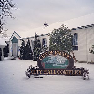
Pacific City Hall
|
|

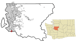
Location of Pacific, Washington within King County
|
|
| Country | United States |
| State | Washington |
| Counties | King, Pierce |
| Government | |
| • Type | Mayor–council |
| Area | |
| • Total | 2.44 sq mi (6.31 km2) |
| • Land | 2.42 sq mi (6.27 km2) |
| • Water | 0.02 sq mi (0.05 km2) |
| Elevation | 79 ft (24 m) |
| Population
(2020)
|
|
| • Total | 7,235 |
| • Estimate
(2021)
|
7,105 |
| • Density | 2,966.12/sq mi (1,145.35/km2) |
| Time zone | UTC-8 (PST) |
| • Summer (DST) | UTC-7 (PDT) |
| ZIP code |
98047
|
| Area code(s) | 253 |
| FIPS code | 53-52495 |
| GNIS feature ID | 1512545 |
Pacific is a city in Washington State. It is located in both King and Pierce counties. Most of the city is in King County. In 2020, about 7,235 people lived there.
Contents
History of Pacific
Pacific was first planned on April 10, 1906. A real estate promoter named Clarence Dayton Hillman created it. He called it "C.D. Hillman's Pacific City Addition to the City of Seattle." The idea was to use the nearby Puget Sound Electric Railway. This railway connected the area to bigger cities like Seattle and Tacoma. Pacific officially became a town on August 10, 1909.
In 1995, Pacific grew by adding a part of Pierce County. This area was not officially part of any city before.
Flooding Events
In November 2006, very heavy rains caused the White River to overflow. The water spread into Pacific City Park. This created a temporary lake that was about 25 acres big.
The 2009 Flooding
On January 8, 2009, the Army Corps of Engineers released water from the Mud Mountain Dam. This dam is on the White River. They had to release water because the reservoir was too full from heavy rain. This rain was causing floods all around the Puget Sound area.
A lot of water was released very quickly. This caused major flooding in Pacific. People living there had almost no warning. The Federal Emergency Management Agency (FEMA) helped those affected by the flood.
Geography of Pacific
Pacific is located at 47°15′48″N 122°14′52″W / 47.26333°N 122.24778°W.
The city covers about 2.43 square miles (6.31 square kilometers). Most of this area, about 2.42 square miles (6.27 square kilometers), is land. A small part, about 0.01 square miles (0.05 square kilometers), is water. The lower White River, also known as the Stuck River, flows through the eastern side of Pacific. It runs between the cities of Auburn and Sumner.
Population and People
| Historical population | |||
|---|---|---|---|
| Census | Pop. | %± | |
| 1910 | 413 | — | |
| 1920 | 320 | −22.5% | |
| 1930 | 347 | 8.4% | |
| 1940 | 357 | 2.9% | |
| 1950 | 755 | 111.5% | |
| 1960 | 1,577 | 108.9% | |
| 1970 | 1,831 | 16.1% | |
| 1980 | 2,261 | 23.5% | |
| 1990 | 4,622 | 104.4% | |
| 2000 | 5,527 | 19.6% | |
| 2010 | 6,606 | 19.5% | |
| 2020 | 7,235 | 9.5% | |
| 2021 (est.) | 7,105 | 7.6% | |
| U.S. Decennial Census 2020 Census |
|||
Pacific's Population in 2010
According to the 2010 census, there were 6,606 people living in Pacific. These people made up 2,269 households. About 1,605 of these were families. The city had about 2,730 people per square mile (1,054 people per square kilometer).
The people in Pacific came from many different backgrounds. About 69.2% were White. 3.1% were African American, and 1.9% were Native American. About 9.0% were Asian, and 1.8% were Pacific Islander. Another 8.5% were from other races, and 6.4% were from two or more races. People of Hispanic or Latino background made up 15.1% of the population.
In 43.0% of households, there were children under 18 years old. About 46.5% of households were married couples living together. The average household had 2.88 people. The average family had 3.32 people.
The average age of people in Pacific was 32.8 years. About 28.1% of residents were under 18. About 10.1% were between 18 and 24. And 7.2% were 65 years old or older. The population was almost evenly split between males and females.
See also
 In Spanish: Pacific (Washington) para niños

