
Painter Run facts for kids
Quick facts for kids Painter Run |
|
|---|---|

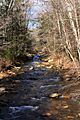
Painter Run looking upstream near its mouth
|
|
| Other name(s) | Painter's Run |
| Physical characteristics | |
| Main source | small pond in a shallow valley in Davidson Township, Sullivan County, Pennsylvania between 2,200 and 2,220 feet (670 and 680 m) |
| River mouth | West Branch Fishing Creek in Davidson Township, Sullivan County, Pennsylvania 1,296 ft (395 m) 41°18′16″N 76°26′07″W / 41.3045°N 76.4354°W |
| Length | 4.5 mi (7.2 km) |
| Basin features | |
| Progression | West Branch Fishing Creek → Fishing Creek → Susquehanna River → Chesapeake Bay |
| Basin size | 5.20 sq mi (13.5 km2) |
| Tributaries |
|
Painter Run (also known as Painter's Run) is a small stream, or tributary, located in Sullivan County, Pennsylvania. It flows into West Branch Fishing Creek. The stream is about 4.5 miles (7.2 km) long. It flows through Davidson Township.
The area of land that drains into Painter Run is 5.20 square miles (13.5 km2). This area is called its watershed. Painter Run has one named smaller stream joining it, called Oxhorn Run. It also has one unnamed stream joining it. The water in Painter Run is slightly acidic. Its pH levels usually range from 5.99 to 6.88. The stream flows through a narrow valley with hills nearby.
Contents
Journey of Painter Run

Painter Run starts in a small pond. This pond is in a shallow valley in Davidson Township. The stream first flows southeast for a short distance. It then receives an unnamed stream from its right side.
Next, Painter Run turns east. Its valley becomes deeper and narrower here. The stream slowly turns south. It then gets another unnamed stream from its left side. After a bit more flowing, it receives another unnamed stream from its right.
The stream then turns southeast for some distance. Its valley continues to get deeper. It receives another unnamed stream from its left. Painter Run then flows southeast for about a mile. It runs alongside State Route 2003. Finally, it slowly turns south-southeast. Here, its only named stream, Oxhorn Run, joins it from the right. A short distance downstream, Painter Run meets West Branch Fishing Creek.
Painter Run joins West Branch Fishing Creek about 6.12 miles (9.85 km) upstream from where West Branch Fishing Creek ends.
Streams Joining Painter Run
Painter Run has one named stream that flows into it. This stream is called Oxhorn Run. It also has one unnamed stream that joins it. Oxhorn Run meets Painter Run about 0.58 miles (0.93 km) upstream from where Painter Run ends. The watershed for Oxhorn Run is 0.87 square miles (2.3 km2). The unnamed stream joins Painter Run about 2.2 miles (3.5 km) upstream from its mouth.
Water Conditions
Scientists have measured the water conditions of Painter Run several times. This helps them understand the stream's health.
The water temperature of Painter Run changes with the seasons. For example, in June, it was about 59.6 °F (15.3 °C). In January, it dropped to about 32.6 °F (0.3 °C).
The pH of water tells us how acidic or basic it is. A pH of 7 is neutral. Lower numbers mean more acidic, and higher numbers mean more basic. Painter Run's pH has been measured between 5.99 and 6.88. This means it is slightly acidic.
The Pennsylvania Department of Environmental Protection has set standards for streams. These standards help protect aquatic life, like fish and insects. Painter Run meets these important standards. However, its tributary, Oxhorn Run, does not meet the standards. It is considered "impaired," meaning its water quality is not as good.
Land and Rocks Around the Stream
The land around Painter Run is interesting. The elevation near where Painter Run joins West Branch Fishing Creek is 1,296 feet (395 m) above sea level. Where Painter Run starts, its elevation is higher, between 2,200 and 2,220 feet (670 and 680 m) above sea level.
Painter Run flows through a narrow valley. This valley is located between two mountains. There is also a ridge (a long, narrow hill) to the north of the stream. Another ridge sits between Painter Run and West Branch Fishing Creek.
The rocks near the start of Painter Run are made of sandstone. This sandstone belongs to something called the Pocono Formation. In most of the stream's valley, you can find different types of soil and rock. These include alluvium (soil deposited by water) and glacial till. Glacial till is a mix of rocks and dirt left behind by ice sheets.
During the last major Ice Age, called the Wisconsinan Glaciation, large sheets of ice moved through this area. Tongues of ice even flowed up the valley of Painter Run.
Painter Run's Watershed
The watershed of Painter Run covers an area of 5.20 square miles (13.5 km2). This entire area is located within the Elk Grove map section of the United States Geological Survey.
One of the unnamed streams that flows into Painter Run is very special. The Pennsylvania Fish and Boat Commission calls it "Class A Wild Trout Waters." This means it's an excellent place for wild trout to live and grow naturally. The very beginning of Painter Run is in a pond.
History of the Area
Painter Run was officially named and added to the Geographic Names Information System on August 2, 1979. This system keeps track of names for places in the United States.
In the past, there were stories about a group called the Fishing Creek Confederacy. It was said they built a fort in the upper part of the Fishing Creek area in 1864. Some believed the remains of this fort were near Painter Run. About a thousand soldiers searched the areas of East Branch Fishing Creek and West Branch Fishing Creek. They were looking for people who had left the army and any signs of a fort. However, they did not find any proof of a fort and returned to Bloomsburg, Pennsylvania.
Two bridges have been built over Painter Run. The first was a steel bridge built in 1930. It is 26.9 feet (8.2 m) long and carries State Route 2003. Another similar bridge was built in 1957. This bridge is 44.0 feet (13.4 m) long and also carries State Route 2003. By 2012, the second bridge needed repairs. Plans were made to fix it in July 2012.
Images for kids
-
Painter Run looking upstream near its mouth
-

Painter Run above Oxhorn Run
