Oxhorn Run facts for kids
Quick facts for kids Oxhorn Run |
|
|---|---|

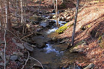
Oxhorn Run looking upstream near its mouth
|
|
| Physical characteristics | |
| Main source | edge of a plateau in Davidson Township, Sullivan County, Pennsylvania between 2,340 and 2,360 feet (710 and 720 m) |
| River mouth | Painter Run in Davidson Township, Sullivan County, Pennsylvania 1,430 ft (440 m) 41°18′40″N 76°26′27″W / 41.3112°N 76.4408°W |
| Length | 1.8 mi (2.9 km) |
| Basin features | |
| Basin size | 0.87 sq mi (2.3 km2) |
Oxhorn Run is a small stream, also called a tributary, that flows into Painter Run. It's located in Sullivan County, Pennsylvania, in the United States. This stream is about 1.8 miles (2.9 km) long and runs through Davidson Township. The area of land that drains into Oxhorn Run, called its watershed, is about 0.87 square miles (2.3 km2).
Scientists have found that the water quality in Oxhorn Run is not as good as it should be. This is mainly due to something called atmospheric deposition and changes in the water's pH level. The land around the stream has different types of soil and rocks. These include materials left behind by glaciers, like sand, gravel, and bedrock made of sandstone and shale.
Contents
Journey of Oxhorn Run
Oxhorn Run starts its journey at the edge of a high, flat area called a plateau in Davidson Township. It first flows towards the south-southeast for a short distance.
Then, the stream turns east and enters a valley. This valley gets deeper and deeper as the stream continues to flow. After a while, Oxhorn Run turns southeast. Its valley keeps getting deeper.
At the bottom of the valley, the stream turns east again. It then crosses a road called State Route 2003. Almost right after crossing the road, Oxhorn Run meets and joins Painter Run. This meeting point is called a confluence. Oxhorn Run joins Painter Run about 0.58 miles (0.93 km) before Painter Run reaches its own end.
Water Quality and Health
The water in Oxhorn Run has some issues. About 1.86 miles (2.99 km) of the stream is considered "impaired." This means its water quality isn't good enough for certain uses, like supporting healthy aquatic life.
The main reasons for this impairment are atmospheric deposition and pH levels. Atmospheric deposition happens when pollution from the air falls into the water. The pH level tells us how acidic or basic the water is. If the pH is too high or too low, it can harm plants and animals living in the stream.
The entire length of Oxhorn Run does not meet the water quality standards set by the Pennsylvania Department of Environmental Protection. In the whole Painter Run watershed, Oxhorn Run is the only stream that doesn't meet these standards.
Land and Rocks Around the Stream
The land around Oxhorn Run has interesting features. Near where Oxhorn Run joins Painter Run, the ground is about 1,430 feet (440 m) above sea level. Where the stream begins, its source, the elevation is much higher, between 2,340 and 2,360 feet (710 and 720 m) above sea level.
The area has different types of soil and rock formations. One common type is called Wisconsinan Till. This is a kind of soil left behind by glaciers. In some lower parts of the stream, this till is found above layers of clay that formed in ancient glacial lakes.
You can also find something called Wisconsinan Ice-Contact Stratified Drift. This material was also left by glaciers. It contains layers of sand and gravel, and sometimes even large boulders. Another type of landform is an alluvial fan. These are fan-shaped deposits of silt, sand, and gravel, also with some boulders.
Underneath these layers, the main type of rock is bedrock. This bedrock is made of sandstone and shale.
The Stream's Drainage Area
The watershed of Oxhorn Run covers an area of about 0.87 square miles (2.3 km2). A watershed is like a giant bowl where all the rain and snow that falls within its boundaries eventually drains into a specific stream or river.
Oxhorn Run is located entirely within a specific map area called the Elk Grove quadrangle, as mapped by the United States Geological Survey. The stream is also part of a larger river system, known as the Upper Susquehanna-Lackawanna drainage basin.
A Look Back in Time
Oxhorn Run was officially added to the Geographic Names Information System on August 2, 1979. This system is like a big dictionary that keeps track of names and locations of places in the United States. Its special ID number in this system is 1183169.
The United States Environmental Protection Agency (EPA) is an organization that works to protect the environment. They listed Oxhorn Run as an impaired stream in both 2002 and 2004. This means they recognized that the stream's water quality was not meeting environmental standards.
 | Charles R. Drew |
 | Benjamin Banneker |
 | Jane C. Wright |
 | Roger Arliner Young |


