
West Branch Fishing Creek facts for kids
Quick facts for kids West Branch Fishing Creek |
|
|---|---|

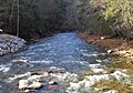
West Branch Fishing Creek near Elk Grove, looking upstream
|
|
| Physical characteristics | |
| Main source | Huckleberry Mountain in Davidson Township, Sullivan County, Pennsylvania |
| River mouth | Fishing Creek in Sugarloaf Township, Columbia County, Pennsylvania 41°16′33″N 76°22′26″W / 41.2759°N 76.3740°W |
| Length | 11.1 mi (17.9 km) |
| Basin features | |
| Basin size | 33.5 sq mi (87 km2) |
| Tributaries |
|
West Branch Fishing Creek is an important stream in Sullivan County, Pennsylvania and Columbia County, Pennsylvania. It's one of the main streams that flows into Fishing Creek. This creek is about 11.1 miles (17.9 km) long. It flows through Davidson Township in Sullivan County and Sugarloaf Township in Columbia County.
The area around the creek, called its watershed, covers about 33.5 square miles. Most of this land is covered by forests. The rocks you can find here include the Catskill Formation, the Huntley Mountain Formation, and the Burgoon Sandstone. Mountains like North Mountain, Huckleberry Mountain, and Central Mountain are also nearby.
The water in West Branch Fishing Creek can be very cold, from about −2 °C (28 °F) (28°F) to warmer temperatures around 23 °C (73 °F) (73°F). The water's pH, which tells us how acidic or basic it is, usually ranges from slightly acidic (around 5.5) to almost neutral (just under 7.0). The amount of water flowing in the creek, called its discharge, can vary a lot, from almost no water to about 25 cubic meters per second.
Small towns like Central and Elk Grove are located in the creek's watershed. In the late 1800s, people used to cut down trees (lumbering) in this area. Many types of fish live in West Branch Fishing Creek, including brown trout, brook trout, and sculpin. The upper parts of the creek are so good for trout that they are special "Class A Wild Trout Waters" according to the Pennsylvania Fish and Boat Commission. You can also find a lot of algae (small plant-like organisms) growing on the bottom of the creek in its lower sections.
Contents
Where Does West Branch Fishing Creek Flow?

West Branch Fishing Creek starts its journey on Huckleberry Mountain. This is in Pennsylvania State Game Lands Number 13 and the southwestern part of Davidson Township, Sullivan County. Right away, it flows into a valley and heads northeast.
Soon, the creek gets water from smaller streams called Swanks Run and Slip Run, which join from its left side. Then, it turns southeast, and its valley gets deeper. The creek continues flowing southeast, passing between Huckleberry Mountain and North Mountain. It picks up two more streams from the left. After that, its first stream from the right, Shingle Mill Run, joins it.
A little later, the creek turns east. It starts getting water from unnamed streams on both sides. After flowing for a few miles, Painter Run joins the creek. Soon after, the creek leaves Davidson Township and Sullivan County.
The Creek's Journey Through Columbia County
When West Branch Fishing Creek leaves Sullivan County, it enters Sugarloaf Township, Columbia County. Right after crossing into Columbia County, the creek flows through the town of Elk Grove. It then flows east-southeast for a short distance.
Next, it reaches the towns of Central and Jamison City. The creek then makes a sharp turn south. It flows between Central Mountain and Huckleberry Mountain, entering a flat area called a plain. After some distance, it turns southwest and goes under Pennsylvania Route 118. Just a few hundred feet downstream, West Branch Fishing Creek meets East Branch Fishing Creek. Together, they form the larger Fishing Creek.
How Much Water is in the Creek?
The amount of water in West Branch Fishing Creek can change a lot. During dry years, like 2001, 2002, 2005, 2007, 2008, and 2010, parts of the creek can dry up. This happens for about 107 days each year on average. But in wet years, like 2003, 2004, 2006, and 2009, the creek only dries up for about 5 days a year. For example, in June 2010, about 0.9 miles (1.4 km) of the creek bed was completely dry.
The usual flow of the creek is from a little above 0 to 5 cubic meters per second. Sometimes, it can be between 5 and 10 cubic meters per second. On rare occasions, it can flow as fast as 25 cubic meters per second.
Water Temperature and Oxygen Levels
The water temperature in West Branch Fishing Creek changes with the seasons. The coldest temperatures, around −1 °C (30 °F) or −2 °C (28 °F), happen in January and February. The warmest temperatures, over 20 °C (68 °F) (68°F), occur in July, sometimes reaching 22 °C (72 °F) or 23 °C (73 °F) (72-73°F).
The amount of dissolved oxygen in the water is very important for fish and other water creatures. It usually ranges from a bit over 6 milligrams per liter to almost 17 milligrams per liter. Fish need at least 5 milligrams per liter to live well. The lowest oxygen levels were in May and June 2010. The highest levels, almost 17 milligrams per liter, were in January and February 2011. West Branch Fishing Creek has the third-lowest minimum oxygen level among the named streams in the upper Fishing Creek area.
Water Acidity and Minerals
West Branch Fishing Creek can become quite acidic at times, more so than most other streams in the upper Fishing Creek watershed. The pH of the creek water usually stays between 5.5 (slightly acidic) and 7.0 (neutral). The amount of alkalinity (which helps balance acidity) in the upper parts of the creek is about 2 milligrams per liter (0.0020 oz/cu ft).
The amount of aluminum dissolved in the water is usually low, less than 40 milligrams per liter, and sometimes almost zero. The highest it gets is 60 to 70 milligrams per liter, which is still below levels that would be harmful to living things. The water's conductivity, which shows how well it carries electricity, ranges from less than 20 to almost 60 micro-siemens per centimeter.
What is the Land Like Around the Creek?

Most of the land around West Branch Fishing Creek is part of the Appalachian Plateau. This area has deep valleys. However, the very lowest parts of the creek, south of Pennsylvania Route 118, are in a different area called the Susquehanna Lowlands. This area is known for its ridges and valleys.
Rock Formations and Soil
The main types of rocks found near West Branch Fishing Creek are the Catskill Formation, the Huntley Mountain Formation, and the Burgoon Sandstone. These rocks are mostly made of sandstone. They also contain conglomerate (rock made of pebbles), shale, and siltstone. These rocks formed a very long time ago, during the Devonian and Mississippian periods.
The Catskill Formation rocks are found mostly in the lower and middle parts of the watershed, along the creek and its smaller streams. The Huntley Mountain Formation is in the upper parts of the watershed. The Burgoon Sandstone is also in the watershed, but not along as many of the streams. The soil in the West Branch Fishing Creek watershed is acidic because there isn't much limestone in the ground.
Ice Age Impact
The West Branch Fishing Creek watershed, like the rest of the upper Fishing Creek area, was covered by glaciers during the Ice Age. You can still see a small pile of rocks and dirt left by a glacier, called a moraine, in the valley of Hemlock Run, which is a stream that flows into West Branch Fishing Creek. The main valley of the creek is a deep, narrow valley, or gorge. This gorge is a major feature of the western part of Pennsylvania State Game Lands #13.
The Creek's Drainage Area

The entire area that drains water into West Branch Fishing Creek, its watershed, is 33.5 square miles. This watershed is about 12.5 miles (20.1 km) long. Most of the watershed is covered by forests. The only towns in the area are Central and Elk Grove. There are also a few homes and seasonal cabins here.
The West Branch Fishing Creek watershed has several smaller areas that drain into it, called sub-watersheds. The largest of these is the Elk Run watershed, which is 7.49 square miles. Elk Run joins the creek about 3.64 miles (5.86 km) from where the creek ends. The second largest is the Painter Run watershed, which is 5.2 square miles. Painter Run joins the creek about 6.12 miles (9.85 km) upstream from its end. Both of these larger sub-watersheds are on the northern side of West Branch Fishing Creek.
A Look Back at the Creek's History
The town of Emmons was started on West Branch Fishing Creek. It was about 5 miles (8.0 km) west of Jamison City. A man named George R. Baum built a sawmill there, and the place was first called Baumstown. A big flood in 1850 destroyed the mill. The area was empty until 1882, when large-scale lumbering (tree cutting) began.
In September 1864, during the American Civil War, about a thousand soldiers from the United States Army searched the valley of West Branch Fishing Creek. They were looking for a rumored fort that was supposedly manned by 500 soldiers who had left the army or avoided being drafted. However, the soldiers couldn't find any fort or deserters.
The town of Elk Grove is located on West Branch Fishing Creek, about 1.0 mile (1.6 km) upstream from Central. Elk Grove was established before 1915. In 1915, it had twelve homes and a hotel called the Elk Grove Hotel. The Pentecost Lumber Company used to cut trees in the area around the creek. They even built a railroad line from the Bloomsburg and Sullivan Railroad at Central, going several miles upstream to Emmons. The Pentecost Lumber Company used this railroad to ship both tree bark and timber to Jamison City.
Animals and Plants in the Creek
The area that drains into West Branch Fishing Creek is special. It's known as a High-Quality Coldwater Fishery and a Migratory Fishery. This means it's a great place for fish that like cold water, and fish can travel through it. However, two smaller streams that flow into it, Shingle Mill Run and Elk Run, are even more special. They are called Exceptional Value waters.
Wild trout naturally reproduce in West Branch Fishing Creek. But sometimes, when parts of the creek dry up, it can stop wild brook trout from moving upstream. Even so, West Branch Fishing Creek has the largest population of wild brook trout of any main stream in the upper Fishing Creek area. In a study where fish were counted using electricity (electrofishing), scientists found 17 sculpin, 11 wild brook trout, 7 escaped trout (whose type wasn't known), 6 brown trout from a hatchery, and 1 brook trout from a hatchery. The Pennsylvania Fish and Boat Commission has marked the creek as Class A Wild Trout Waters from its start down to the stream called Hemlock Run, which is about 2.50 miles (4.02 km) long.
Algae and Insects in the Water
In one spot on West Branch Fishing Creek, downstream from Elk Grove, more than 60% of the creek bed is covered by benthic algae. This high amount of algae might be happening because of leaky septic tanks in the area. In Elk Grove, there are between 100 and 200 aquatic macroinvertebrates (small water insects and other creatures) per square meter in the creek. Further upstream, there are almost 300 macroinvertebrates per square meter.
At the very beginning of the creek, about 25% of the macroinvertebrates are stoneflies (Plecoptera), about 25% are mayflies (Ephemeroptera), about 25% are caddisflies (Trichoptera), about 20% are midges (Chironomidae), and about 5% are other types. Near where the creek ends, about 20% are stoneflies, about 55% are mayflies, about 20% are caddisflies and midges, and about 5% are other types.
Creek Habitat Quality
You can find woody debris, like fallen branches, in West Branch Fishing Creek. The area of trees and plants along the creek banks, called the riparian buffer, is continuous and healthy.
In 2011, scientists rated the quality of the habitat in upper Fishing Creek and its smaller streams. They used a scale from 1 to 200, where a higher number means better habitat. The very start of West Branch Fishing Creek scored 191. This was tied with West Creek for the highest score in the entire upper Fishing Creek watershed. Most of West Branch Fishing Creek received a rating between 166 and 200, which means it has excellent habitat quality. However, the lower parts of the creek scored between 113 and 165, which is still good but not as perfect.
The Shannon Diversity Index, which measures how many different types of creatures live in a place, is between 2.0 and 2.5 at Elk Grove. Further upstream, it's about 2.8, showing even more variety. The Hilsenhoff Biotic Index, which tells us about water pollution based on the insects present, is between 2.6 and 3.5 in the lower parts of the creek (downstream of Painter Run). Between Shingle Mill Run and Painter Run, it's between 1.6 and 2.5. Lower numbers mean cleaner water.
Images for kids
-
West Branch Fishing Creek near Elk Grove, looking upstream
-
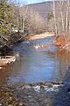
West Branch Fishing Creek in December
-
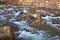
Rapids on West Branch Fishing Creek
-
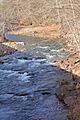
West Branch Fishing Creek from State Route 4049
