Elk Run (West Branch Fishing Creek tributary) facts for kids
Quick facts for kids Elk Run |
|
|---|---|

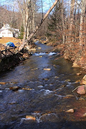
Elk Run looking upstream in Elk Grove
|
|
| Physical characteristics | |
| Main source | northern edge of North Mountain in northern Davidson Township, Sullivan County, Pennsylvania between 2,240 and 2,280 feet (680 and 690 m) |
| River mouth | West Branch Fishing Creek in Davidson Township, Sullivan County, Pennsylvania 1,171 ft (357 m) 41°18′20″N 76°24′23″W / 41.3055°N 76.4064°W |
| Length | 4.8 mi (7.7 km) |
| Basin features | |
| Progression | West Branch Fishing Creek → Fishing Creek → Susquehanna River → Chesapeake Bay |
| Basin size | 7.49 sq mi (19.4 km2) |
| Tributaries |
|
Elk Run is a small stream, also called a tributary, that flows into West Branch Fishing Creek. It runs through Sullivan County and Columbia County in Pennsylvania, USA. The stream is about 4.8 miles (7.7 km) long.
Elk Run flows through Davidson Township and Sugarloaf Township. The area of land that drains into the stream, called its watershed, is about 7.49 square miles (19.4 km2).
This stream has three smaller streams that flow into it: Gallows Run, Hog Run, and Long Run. Elk Run is very special because it's known as an "Exceptional Value" stream. This means it's super clean and healthy. It's also a "Migratory Fishery," which is important for fish that travel. The forests around Elk Run are also very important for nature. The stream got its name because an elk was killed there in the 1840s.
Some parts of Elk Run are affected by air pollution, called atmospheric deposition. Long ago, glaciers shaped the land near the stream. A bridge was built over Elk Run in the year 2000.
Contents
Elk Run's Journey
Elk Run starts high up on the northern edge of North Mountain. This is in northern Davidson Township, Sullivan County. At first, it flows southeast for a short distance. Then, it enters a deep valley. Here, a small unnamed stream joins it from the left side.
The stream then turns towards the south-southwest. Its valley gets even deeper. After a while, its first named tributary, Gallows Run, joins it from the right side. Elk Run then turns towards the south-southeast. Over the next few miles, two more streams, Hog Run and Long Run, flow into it from the left. Finally, Elk Run reaches the small village of Elk Grove and leaves Sullivan County.
After leaving Sullivan County, Elk Run enters Sugarloaf Township in Columbia County. It keeps flowing south-southeast through Elk Grove. Soon after, the stream meets and joins West Branch Fishing Creek.
Elk Run joins West Branch Fishing Creek about 3.64 miles (5.86 km) before West Branch Fishing Creek reaches its own end.
Streams Joining Elk Run
Elk Run has three named streams that flow into it. These are Gallows Run, Hog Run, and Long Run.
- Gallows Run joins Elk Run about 2.68 miles (4.31 km) upstream from its mouth. The area that drains into Gallows Run is about 0.50 square miles (1.3 km2).
- Hog Run joins Elk Run about 1.46 miles (2.35 km) upstream from its mouth. Its watershed covers about 1.05 square miles (2.7 km2).
- Long Run joins Elk Run about 0.42 miles (0.68 km) upstream from its mouth. The land area that drains into Long Run is about 1.92 square miles (5.0 km2).
Water Quality of Elk Run
About 0.43 miles (0.69 km) of Elk Run and its smaller unnamed streams are considered "impaired." This means the water quality isn't as good as it should be. In Columbia County, about 0.1 miles (0.16 km) of the stream is impaired. The main reason for this impairment is atmospheric deposition. This is pollution that falls from the air, often from faraway sources.
Land and Rocks Around Elk Run
The land around where Elk Run meets West Branch Fishing Creek is about 1171 feet (357 m) above sea level. Where the stream begins, its source, the elevation is higher, between 2240 and 2280 feet (680 and 700 m).
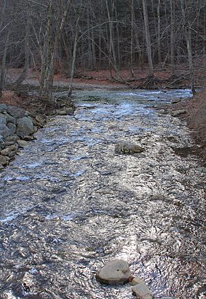
Elk Run flows quickly because it has a "high gradient," meaning it drops a lot in elevation over a short distance. It is also a "clearwater creek," which means its water is very clear.
The valley of Elk Run has different types of soil and rocks. Much of it is near something called Wisconsinan Ice-Contract Stratified Drift. There's also a type of glacial till called Wisconsinan Bouldery Till, and alluvium, which is soil deposited by water. Near where the stream starts, you can find Wisconsinan Till. The slopes of the valley are made of bedrock like sandstone and shale.
Long ago, during the late Wisconsin glaciation (a time when glaciers covered much of the land), the area where Elk Run begins was at the edge of a glacier. A "tongue" of ice flowed down the stream's valley. This ice joined with another ice tongue in the village of Elk Grove.
Elk Run's Watershed
The watershed of Elk Run covers an area of 7.49 square miles (19.4 km2). This entire area is located within the Elk Grove map area, according to the United States Geological Survey. The part of the stream in Columbia County is in northern Sugarloaf Township.
Elk Run is in the headwaters (the beginning) of the larger watershed for Fishing Creek. It is also found within Pennsylvania State Game Lands Number 13, which is a protected area for wildlife.
Near where Elk Run begins, there is a wetland. Wetlands are important areas where the land is covered by water, supporting unique plants and animals.
History and Name of Elk Run
Elk Run was officially added to the Geographic Names Information System on August 2, 1979. This system helps keep track of names for places in the United States.
A special bridge was built over Elk Run in Elk Grove in the year 2000. This bridge carries State Route 4049 and is 43.0 feet (13.1 m) long. The Pennsylvania Fish and Boat Commission studied the stream in 1994 to learn more about its fish.
The stream's name comes from an interesting event in the 1840s. Hunters Benjamin McHenry and Silas Jackson killed an elk near Elk Run. The elk died in the stream itself. At that time, elk were very rare in Columbia County and in northeastern Pennsylvania. Because of this rare event, the stream was named after the elk. It's one of about a thousand natural places in the United States named after elk.
Animals and Plants of Elk Run
Wild trout live and reproduce naturally in Elk Run, from where it starts all the way to its mouth. The entire area that drains into Elk Run is called an "Exceptional Value" stream. This means it's a very important and healthy place for nature. It's also a "Migratory Fishery," which means it's a key spot for fish that travel. In the 1990s, Elk Run was known for having a good amount of wild brook trout. The total weight of trout in the stream is more than 20 kilograms per hectare.
Around the year 1900, a lynx that was nearly 6 feet (1.8 m) long was seen near Elk Run.
A forest area along Elk Run is considered "locally significant" by the Sullivan County Natural Areas Inventory. This forest acts as a riparian buffer for the stream. A riparian buffer is a strip of trees and plants along a stream that helps protect its water quality. This forest has trees of different ages. Some trees have trunks that are more than 1 foot (0.30 m) thick.
The slopes in this forest mostly have sugar maple trees. But there are also smaller numbers of basswood, beech, hemlock, white ash, and yellow birch trees. The "shrub layer" of the forest, which is made of smaller bushes, is very well-developed. It includes plants like elderberry, striped maple, and witch hazel. Many different herbaceous plants (plants with soft stems) grow here too, such as asters, Christmas ferns, foamflowers, and wood sorrels.
 | Sharif Bey |
 | Hale Woodruff |
 | Richmond Barthé |
 | Purvis Young |


