Pakowki, Alberta facts for kids
Quick facts for kids
Pakowki
(Blackfoot) "Bad Water"
|
|
|---|---|

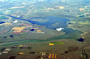
Aerial view of Pakowki Lake about 10km south of the former town site of Pakowki.
|
|
| Country | Canada |
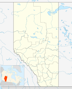
| Province | Alberta |
| Region | Southern Alberta |
| Census division | 1 |
| Municipal district | County of Forty Mile No. 8 |
| Time zone | UTC−7 (MST) |
| • Summer (DST) | UTC−6 (MDT) |
| Postal code span |
NA
|
| Area code(s) | +1-403 |
| Highways | Highway 61 |
| Waterways | Pakowki lake |
Pakowki is a small, quiet place in Alberta, Canada. It's not a big city or town, but more like a tiny settlement in the countryside. You can find it along Highway 61 in southeastern Alberta.
Pakowki is known as a ghost town, which means most people have moved away, and not much is left. It's one of many such places along the old Red Coat Trail route. The name "Pakowki" comes from Pakowki Lake, which is about 10 kilometers (6 miles) south. In the Blackfoot language, "Pakowki" means "Bad Water."
Today, very little remains of Pakowki. You might see old building foundations or marks in the ground where buildings once stood. The only building still around is the former Canadian Pacific Railway section house, but it was moved to a nearby community.
Contents
Why Pakowki Became a Ghost Town
Many ghost towns in Western Canada were created for different reasons. Sometimes, a mine would run out of valuable minerals, causing the town around it to disappear. Other times, changes in world markets or natural disasters could lead to a town's end. However, Pakowki became a ghost town mainly because of mistakes made by the people who planned it.
The Railway Arrives
The Canadian Pacific Railway (CPR) built a railway line that reached the Pakowki area in 1915. Almost overnight, a small town quickly appeared. Even though the year before had been very bad for farming, with hardly any crops harvested, some of the first buildings put up were grain elevators. This showed how much hope people had for the area.
What Pakowki Looked Like
If you travel about 6.5 miles (10.5 kilometers) east on Highway 61 from Etzikom, you can reach the site of Pakowki. The land around it is gently rolling and can be quite beautiful, even when it's dry.
On the right side of a small hill, you can see a large stockyard. Further down, as the highway dips, you might spot a small railway building with a sign that says "Pakowki." The actual town used to be west of the stockyards, right next to the railway tracks. Now, only broken foundations mark where it once stood.
Pakowki had a decent-sized main street that ran along the railway. There was a store called Everson and Gilchrist on the east end. Next to it was a Chinese restaurant, and then the Pioneer House, a hotel owned by the Dillenbecks. Further down the street, C. Potter had a machine shop and sold Model T cars and trucks. The town also had a lumber yard and two general stores.
Hopes for Farming
In the fall of 1915, there was a very good harvest, and the crops were stored in a large warehouse near the tracks. The next year, with high hopes, two proper grain elevators were built. These were meant to handle crops from nearly 1,400 square miles (3,600 square kilometers) of homestead land, which was land given to settlers for farming. One of the busiest places in town was Smith's barbershop and pool hall, where farmers could relax and get a shave or haircut.
The "Bad Water" Name
The name Pakowki, as mentioned, means "Bad Water" in the Blackfoot language. A large lake to the south was noted by explorer Palliser, who put it on his 1865 map as Peekopee. For the business people in 1915, the name might have felt like "bad medicine" for their town's future.
The Railway Moves On
Even though there were still many miles of track to be laid between Stirling and Weyburn, the CPR was not in a hurry. Slowly, they extended their railway eastward to a small settlement called Manyberries, reaching it in the fall of 1916.
As the railway slowly moved across the flat, open land, it often built a "Y" shape on the prairie. This allowed trains to turn around. Manyberries became the end of the line for years. In fact, it turned out that the railway line past Etzikom was already too long for the amount of traffic. Trains only ran twice a week.
Why Pakowki Lost Its People
Pakowki had one big problem that wasn't fully understood when the town was first built. Most of the best homestead land was located to the north and east of Pakowki. So, when the railway moved on to a new stop called Orion, settlers quickly started going to the new town instead, because it was closer. Since everyone traveled by horse and wagon, farmers were happy to have shorter trips to town.
Even though the good harvests continued through 1916, Pakowki's future was already in doubt. The Dillenbecks moved their hotel and restaurant to Orion, and other businesses soon followed. Within just a few months, all that was left of the once-promising prairie town were the section house, piles of used lumber, and the empty basements of houses.
Today, a set of stockyards, which belong to the Community Pasture Association, overlooks the ghost town of Pakowki. In the early 2000s, the CPR stopped using the less busy Stirling-Weyburn railway line.
 | Emma Amos |
 | Edward Mitchell Bannister |
 | Larry D. Alexander |
 | Ernie Barnes |


