Palen Creek, Queensland facts for kids
Quick facts for kids Palen CreekQueensland |
|||||||||||||||
|---|---|---|---|---|---|---|---|---|---|---|---|---|---|---|---|

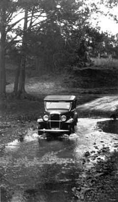
Driving across Palen Creek, 1934
|
|||||||||||||||
| Population | 368 (2021 census) | ||||||||||||||
| • Density | 3.651/km2 (9.46/sq mi) | ||||||||||||||
| Postcode(s) | 4287 | ||||||||||||||
| Area | 100.8 km2 (38.9 sq mi) | ||||||||||||||
| Time zone | AEST (UTC+10:00) | ||||||||||||||
| Location |
|
||||||||||||||
| LGA(s) | Scenic Rim Region | ||||||||||||||
| State electorate(s) | Scenic Rim | ||||||||||||||
| Federal Division(s) | Wright | ||||||||||||||
|
|||||||||||||||
Palen Creek is a small country area in the Scenic Rim Region of Queensland, Australia. It is very close to the border with New South Wales. In 2021, about 368 people lived in Palen Creek.
A small part of Palen Creek is known as Tylerville. It is a neighbourhood within the area.
Contents
Exploring Palen Creek's Landscape
Palen Creek has a very rugged landscape. It has many sloped areas covered in thick plants and trees. The lowest parts are about 90 meters above sea level. In the south, the McPherson Range mountains rise to over 600 meters high.
You can find parts of Palen State Forest here. Also, a section of Mount Barney National Park is in the southeast. Another forest area is on the slopes of Mount Giles in the west. The Mount Lindesay Highway winds through the valley between these two forest areas.
The Palen Creek Waterway
The Palen Creek waterway starts in the southern part of the area. It begins just north of the border with New South Wales. This creek then flows north through Palen Creek. It eventually joins the Logan River near Rathdowney. The locality of Palen Creek is named after this creek.
Palen Creek Correctional Centre
The Palen Creek Correctional Centre is located on the highway in the southwest. This facility is a place where up to 170 people can stay. It is a low-security prison set in a rural environment.
A Look at Palen Creek's Past
In 1877, a large area of land was made available for people to settle. This land was about 15,500 acres. It was taken from two big farming areas called Melcombe and Palen.
Timber Industry and Sawmills
Cutting down trees for wood was a very important business early on. There were two sawmills in the area. One was in Palen Creek, owned by a family called Campbells. The other was in Tylerville, owned by Alfred John Raymond. These sawmills are no longer there today.
Early Schools in the Area
Palen Creek Provisional School first opened its doors on October 23, 1893. It became Palen Creek State School in 1909. This school closed down in 1962. It was located near the Palen Creek School Road and Mount Lindesay Highway junction.
Tylerville State School also opened in 1909, on January 18. It closed in 1962, the same year as Palen Creek State School. It was located on the Mount Lindesay Highway.
Local Churches and Community Life
The Barney View Lutheran Church was officially opened on November 16, 1910. Services were given in both German and English. This church closed in 1966. Later, in the 1970s, the church building was moved to Rathdowney. It was used to make the Rathdowney Methodist Church bigger.
The Lutheran Church still owns the land where the church used to be. This land is now called Abode Park. It is used as a campsite. The park is named after Pastor Armin Bode, who was a Lutheran minister there for many years. A special memorial at the park remembers the old church.
Palen Creek Methodist Church opened on May 10, 1913. In 1957, this church building was also moved to Rathdowney. It was later made even bigger in the 1970s. When the Methodist Church joined with other churches in 1977, it became the Palen Creek Uniting Church. Its last service was on February 23, 2014. The building is now privately owned.
Palen Creek's Population Over Time
In 2011, Palen Creek and the areas around it had a population of 219 people. By 2016, the population of Palen Creek grew to 280 people. The most recent count in 2021 showed that 368 people lived in Palen Creek.
Important Heritage Sites
Palen Creek has one site that is listed as a heritage place. This means it is important to the history of the area.
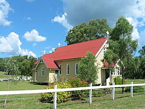
- The Mount Lindesay Highway is home to the St James Catholic Church and its cemetery. This site is located at 11605 Mount Lindesay Highway.
Education for Local Students
There are no schools located directly in Palen Creek. Students usually travel to nearby towns for their education. The closest primary school is Rathdowney State School in Rathdowney. For high school, students can go to Beaudesert State High School in Beaudesert. Another option is Boonah State High School in Boonah.
 | George Robert Carruthers |
 | Patricia Bath |
 | Jan Ernst Matzeliger |
 | Alexander Miles |


