Pancake Range facts for kids
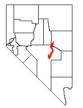
The Pancake Range is a mountain chain located in east-central Nevada, a state in the United States. It stretches like a winding line for about 90 miles (145 km) from north to south. This mountain range is found in Nye and White Pine counties. The highest point in the Pancake Range is Portuguese Mountain, which stands at 9,240 feet (2,816 meters) tall.
Nearby mountain ranges include the White Pine, Grant, and Quinn Canyon ranges to the east. To the west, you'll find the Park and Hot Creek ranges. The Lunar Crater Volcanic Field, an area with old volcanoes, is at the southwestern end of the Pancake Range.
Location and Travel
The cities of Ely and Eureka are located near the northern part of the Pancake Range. US Route 50, a major highway, crosses the very northern tip of the range at Pancake Summit. This summit is 6,521 feet (1,988 meters) high.
Further south, the community of Duckwater and the Duckwater Indian Reservation are located to the east of the range. U.S. Route 6 also crosses the Pancake Range at Sandy Summit. This crossing is north of the Lunar Crater area. Another road, Nevada Route 375, known as the Extraterrestrial Highway, runs through the valley east of Warm Springs, between the Pancake and Reveille ranges.
Nature and Wildlife
Most of the Pancake Range, about 99.9%, is managed by the Bureau of Land Management. This agency helps protect and care for the land.
Plants
You can find several types of trees growing in the Pancake Range. These include:
- Utah Juniper (Juniperus osteosperma)
- Single-leaf Pinyon (Pinus monophylla)
- Rocky Mountain Juniper (Juniperus scopulorum)
Animals
The Pancake Range is home to various mammals. Some of the animals you might see here are:
- Pronghorn (a fast North American animal)
- Long-tailed pocket mouse
- Chisel-toothed kangaroo rat
- Little pocket mouse
Why the Name "Pancake Range"?
The Pancake Range got its interesting name because of its shape. The mountains have a relatively flat outline, much like a stack of pancakes!
 | Precious Adams |
 | Lauren Anderson |
 | Janet Collins |


