
Payún Matrú facts for kids
Quick facts for kids Payún Matrú |
|
|---|---|
.jpg)
Payún Matrú
|
|
| Highest point | |
| Elevation | 3,715 m (12,188 ft) |
| Geography | |

Payún Matrú
Location in Argentina
|
|
| Parent range | Andes |
| Geology | |
| Mountain type | Shield volcano |
| Last eruption | 515 ± 50 years ago |
Payún Matrú is a large, flat volcano called a shield volcano. It is located in the Reserva Provincial La Payunia in the southern part of the Mendoza Province in Argentina. This volcano is part of a bigger area called the Andean Volcanic Belt. It formed because the Nazca Plate (a huge piece of the Earth's crust) is slowly sliding under the South American Plate.
Payún Matrú is part of the Payenia volcanic area, which also includes other volcanic fields like Llancanelo and Nevado. Since 2011, people have suggested that Payún Matrú should become a World Heritage Site because of its unique features.
The volcano sits on top of older rocks and sediments. It has a huge bowl-shaped area at its top called a caldera. This caldera formed during a massive explosive eruption between 168,000 and 82,000 years ago. Payún Matrú also includes a tall, cone-shaped volcano called Payun or Payun Liso, and many smaller scoria cones with long lava flows. One of these lava flows, called Pampas Onduladas, is super long. It stretches for about 167 to 181 kilometers (104 to 112 miles)! It's the longest lava flow from the last 2.58 million years on Earth.
Volcanic activity at Payún Matrú started a long time ago, millions of years in the past. After the big caldera formed, eruptions continued both inside and outside the caldera. These eruptions created lava domes, more lava flows, and new scoria cones. The volcano was active until about 515 years ago. Local stories even talk about eruptions that happened before Europeans arrived.
Contents
What's in a Name?
The name Payún or Paium means "bearded" in the local language. The word Matru means "goat". So, Payún Matrú could mean something like "bearded goat" or "goat's beard" volcano. The whole area is sometimes called Payenia.
Where is Payún Matrú?
Location and Surroundings
Payún Matrú is in the Malargüe Department of the Mendoza Province in Argentina. It's a tough place to live because there isn't much fresh water and it's very high up. But, there are good roads like National Route 40 that pass nearby. The volcano is protected within the Reserva Provincial La Payunia. Because it has so many different volcanic shapes and features, it was added to UNESCO's list of potential World Heritage Sites in 2010.
This active volcanic area is part of the Southern Volcanic Zone. This zone is a 1,000-kilometer (620-mile) long chain of volcanoes in the Andes mountains. It's one of four main volcanic belts in the Andes.
The Volcano's Shape
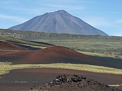
Payún Matrú is a wide shield volcano, about 15 kilometers (9.3 miles) across. It rises about 2 kilometers (1.2 miles) above the land around it. Its lava flows cover about 5,200 square kilometers (2,000 square miles). The volcano has different types of landforms. Its northern and eastern sides are flat and covered by volcanic ash and rock called Ignimbrites. The western and southern sides have rougher surfaces with lava domes and coulées (thick lava flows). Wind has also shaped the rocks, creating grooves and tall, narrow ridges called yardangs. The total amount of rock in this shield volcano is huge, about 240 cubic kilometers (58 cubic miles).

At the top of the shield volcano is a large caldera, which is like a big crater. It's about 7 to 8 kilometers (4.3 to 5 miles) long and 480 meters (1,570 feet) deep. This caldera covers an area of about 56 square kilometers (22 square miles). Several peaks surround it, including Cerro Matru. The caldera used to be wider, but erosion and later eruptions have changed its size. Inside the caldera, there's a permanent lake called "Laguna," which gets its water from melting snow and rain.
The highest active point of the Payún Matrú area is the Payun stratovolcano, which is 3,796 meters (12,454 feet) high. It's also known as Payun Liso. This cone-shaped volcano rises 1.8 kilometers (1.1 miles) from the southern side of Payún Matrú, about 10 kilometers (6.2 miles) from the caldera. It has a crater at its top that opens to the north.
-
The Payun volcano
-
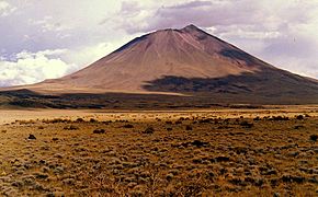
The Payun volcano
-
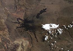
Payún Matrú seen from space


Payún Matrú Volcanic Field
Besides the main caldera, the area has about 300 individual volcanic vents. These vents have different shapes and are grouped into western (Los Volcanes) and eastern (Guadaloso and El Rengo) areas. These groups include fissure vents (cracks in the ground), lapilli cones, scoria cones, and strombolian cones. These volcanic hills can be up to 225 meters (738 feet) high. They are linked to lava flows and pyroclastic (hot ash and rock) units. Wind has also created ash "tails" behind some of the vents.
Older lava flows have smooth, ropey surfaces called pahoehoe lava, with lava tubes (tunnels formed by flowing lava). Newer lava flows are often rough and blocky, known as aa lava. Some lava flows reached the Rio Grande River west of Payún Matrú, blocking it. The river then cut through the lava, forming flat-topped landforms and canyons. One famous canyon is La Pasarela, where you can clearly see the structures of the lava flows.
The entire volcanic field covers more than 12,000 square kilometers (4,600 square miles). Some of its lava flows have reached Llancanelo Lake to the north and the Salado River to the east. The total amount of lava from Payún Matrú is estimated to be about 350 cubic kilometers (84 cubic miles). Most of this lava came from Strombolian and Hawaiian eruptions, which are generally less explosive.

The volcanic cones are often lined up along cracks in the Earth's crust called lineaments. These lines show where the ground is stressed underground. One important crack is the La Carbonilla fracture, which runs east–west. It seems to have played a big role in how Payún Matrú formed.
Some of the cones in Payún Matrú include:
- Los Morados: This is a group of scoria cones and vents that had a sector collapse (part of the volcano broke off) and intense Strombolian activity.
- Pampas Negras: This is a flat area of small volcanic rocks (lapilli) next to Los Morados. It formed from ash falling during Strombolian eruptions, and wind has created dunes there.
- Morado Sur: This has two cones that formed in the same eruption and are covered with reddish deposits.
- Volcán Santa María: This cone is 180 meters (590 feet) high and has a small crater. It's covered with red scoria and lava bombs.
Pampas Onduladas: Giant Lava Flows
Payún Matrú is famous for having the longest lava flow from the last 2.58 million years on Earth. It's called the Pampas Onduladas lava flow and is in the eastern and northern parts of the volcanic field. This flow started from the La Carbonilla fault and then split into two branches. The longer southeastern branch reaches all the way to the Salado River in the La Pampa Province.
This huge lava flow moved over gentle land. It has features like "lava rises" and "lava tumuli" (small mounds) where the flow met obstacles. The lava flowed unusually fast because it wasn't very thick and the land was sloped just right. It built up to a volume of at least 7.2 cubic kilometers (1.7 cubic miles) and covered about 739 square kilometers (285 square miles). Its length is between 167 and 181 kilometers (104 and 112 miles). Scientists think these long lava flows form when a crust develops on top, protecting the lava underneath from cooling. Then, more magma flows in, making the lava flow "inflate" and spread out in layers. Some parts of Pampas Onduladas have been covered by newer lava flows.
Pampas Onduladas is one of only a few lava flows in the last 2.58 million years that reached over 100 kilometers (62 miles) long. It's similar to some long lava flows found on Mars. Other large lava flows in the area include Los Carrizales and La Carbonilla. There are also long lava flows south of Payún Matrú, like El Corcovo, Pampa de Luanco, and Pampa de Ranquelcó, which are 70 to 122 kilometers (43 to 76 miles) long.
Water and Landscape
Other than the lake in the caldera, the Payún Matrú area doesn't have many permanent water sources. Most water spots are temporary or only appear after rain. There are no permanent rivers in the volcanic field either. Most rain quickly sinks into the sandy ground. The whole area is surrounded by sandy plains, which are volcanic rocks covered by wind-blown sand.
How Payún Matrú Formed
Plate Tectonics
West of South America, two large pieces of Earth's crust, the Nazca Plate and the Antarctic Plate, are sliding under the South America Plate. This movement happens at a speed of about 66 to 80 millimeters (2.6 to 3.1 inches) per year. This process, called subduction, creates the Andean Volcanic Belt. The volcanic belt isn't continuous; it has gaps where the plates slide more shallowly.
There's evidence of older volcanic activity in the region, but the recent volcanic activity that formed Payún Matrú started about 5.333 to 2.58 million years ago. This activity is linked to the way the Nazca Plate slides under the South American Plate.
Local Geology
The rocks beneath Payún Matrú are very old, ranging from 1,600 to 1,000 million years old to more recent sediments and lava flows. The Andean orogeny (mountain-building process) during the Miocene (23.03 to 5.333 million years ago) folded and shaped these older rocks.

Payún Matrú is part of a volcanic area located about 200 kilometers (120 miles) east of the Andes mountains. Its volcanic activity is still connected to the Nazca Plate sliding under the South American Plate. Scientists think that changes in how the plates slid led to cracks in the Earth's crust. These cracks then became pathways for magma (molten rock) to rise to the surface.
Other volcanic fields nearby include Llancanelo volcanic field, Nevado volcanic field, and Salado Basin volcanic field. These fields, along with Payún Matrú, are part of the larger Payunia volcanic province. This province covers about 36,000 square kilometers (14,000 square miles) and has more than 800 smaller volcanoes. Even though there are many volcanoes, no eruptions have been seen here since Europeans arrived.
Lava and Magma
The rocks from Payún Matrú show that the volcano has produced many different types of lava. These range from alkali basalts (dark, runny lava) to rhyolite (light-colored, thick lava). The volcanic rocks contain different types of crystals, like olivine and plagioclase. The temperature of the magma inside the volcano is very hot, estimated to be between 1,122 and 1,276 degrees Celsius (2,052 and 2,329 degrees Fahrenheit).
The magma from Payún Matrú is similar to lava found on ocean island basalts. This suggests that the magma comes from deep inside the Earth. Scientists believe there's a "plume" (a rising column of hot rock) that brings magma from 200 to 400 kilometers (120 to 250 miles) deep up to Payún Matrú.
The magma forms when parts of the Earth's mantle melt. This melted rock then changes as it rises, mixing with other magmas and absorbing material from the Earth's crust. Finally, the magma reaches the surface through deep cracks in the ground. The large size of Payún Matrú itself can block magma from rising easily. This is why more "evolved" (changed) magmas erupt near the caldera, while more basic magmas erupt outside the main volcano.
Obsidian (a type of volcanic glass) from Payún Matrú has been found at old archeological sites. However, it wasn't used much, maybe because it wasn't the best quality or it was hard to get to the volcano. The Payun volcano is also known for large crystals of hematite.
Climate, Plants, and Animals
The climate at Payún Matrú is cold and dry, with strong winds from the west. Temperatures usually range between 2 and 20 degrees Celsius (36 and 68 degrees Fahrenheit). The area gets only about 200 to 300 millimeters (7.9 to 11.8 inches) of rain each year. It's dry because the Andes mountains block moisture-carrying winds from reaching Payún Matrú. Strong winds and evaporation also make it drier. The higher parts of Payún Matrú might have had snow and ice during past ice ages.
The plants in the volcanic field are mostly sparse bushes and grasses, with very few trees. This type of plant life is called xerophytic, meaning it's adapted to dry conditions. The soils are shallow and mostly rocky or sandy. You can find Opuntia cactus and grasses like Poa and Stipa.
Payún Matrú is home to many animals, including armadillos, black-chested buzzard-eagles, condors, Darwin's rheas, guanacos, maras, Pampas foxes, pumas, and Southern viscachas. Some types of lizards may have even developed unique features on these volcanoes.
Volcanic Eruptions
.jpg)
The history of eruptions at Payún Matrú is not fully known, but the volcano has been active for millions of years. The oldest eruptions seem to have happened in the eastern part of the field, about 0.95 to 0.6 million years ago.
The very long Pampas Onduladas lava flow erupted about 373,000 years ago. The Payun volcano formed around 265,000 years ago, over a period of about 2,000 to 20,000 years.
The main Payún Matrú volcano formed over about 600,000 years. Its oldest rocks are about 700,000 years old. Before the caldera collapsed, the volcano might have been as tall as the Payun volcano is today.
The huge caldera formed when the Portezuelo Ignimbrite erupted, between 168,000 and 82,000 years ago. This eruption spread volcanic ash and rock radially around the caldera. It covered an area of about 2,200 square kilometers (850 square miles) and had a volume of about 25 to 33 cubic kilometers (6 to 7.9 cubic miles). This event was likely caused by new magma entering the magma chamber. The eruption was a Plinian eruption, which means it created a tall column of ash and gas. When this column collapsed, it produced the ignimbrites. Eventually, the top of the volcano collapsed, forming the caldera. After this, volcanic activity continued, creating lava domes and flows inside the caldera.
Eruptions of basaltic and trachyandesitic lava continued after the caldera formed. Some volcanic cones, like El Rengo and Los Volcanes, appear to be from the last 11,700 years (Holocene period).
Uneroded cones and dark lava flows show that activity continued into the Holocene. Stories from local indigenous tribes suggest that eruptions happened within the last few centuries. However, no eruptions have been seen since Europeans settled in the area. If future eruptions happen, they are unlikely to be very dangerous because the area has very few people. But, roads might be blocked, and lava could dam rivers. Payún Matrú is considered Argentina's 24th most dangerous volcano out of 38.
Scientists have used different methods to figure out the ages of past eruptions. Here are some of the ages they found for eruptions in the last 44,000 years:
- 44,000 years ago
- 43,000–41,000 years ago (El Puente Formation)
- 41,000 years ago (under the Los Morados lava flow)
- 37,000 years ago (near the Rio Grande River)
- 37,000 years ago (La Planchada fallout deposit)
- 37,000 years ago (northwestern side of the caldera)
- 28,000 years ago (lava flow on the western side)
- 26,000 years ago (near the Rio Grande)
- 26,000 years ago (another lava flow)
- 26,000 years ago (rhyolitic lava flow)
- 20,000 years ago (north of the caldera)
- 16,000 years ago (under the Los Morados lava flow)
- 15,200 years ago (lava flow on the northwesterly-westerly side)
- 9,000 years ago
- 7,000 years ago (Escorial del Matru within the caldera)
- Less than 7,000 years ago (trachyandesitic lava flow in the western part)
- 4,760 years ago
- 6,900 years ago (Guadalosos cones)
- 2,000 years ago (young-looking lava flow in the west)
- 1,470 years ago (Volcán Santa María)
- 515 years ago (Morado Sur cone)
Images for kids
-

Stratigraphy of Payún Matrú
See also
 In Spanish: Payún Matrú para niños
- List of volcanoes in Argentina
