Penbryn facts for kids
Quick facts for kids Penbryn |
|
|---|---|
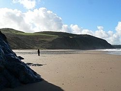
 Penbryn beach |
|
| Population | 1,270 (2011) |
| OS grid reference | SN294520 |
| Principal area | |
| Ceremonial county | |
| Country | Wales |
| Sovereign state | United Kingdom |
| Post town | LLANDYSUL |
| Postcode district | SA44 |
| Post town | CARDIGAN |
| Postcode district | SA43 |
| Dialling code | 01269 |
| Police | Dyfed-Powys |
| Fire | Mid and West Wales |
| Ambulance | Welsh |
| EU Parliament | Wales |
| UK Parliament |
|
| Welsh Assembly |
|
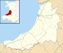
Penbryn (grid reference SN296520) is a small village and community located on the coast of Ceredigion, Wales. It is about 8 miles (13 km) from the town of Cardigan. This quiet area is known for its beautiful beach and interesting history.
Contents
Discovering Penbryn's Past
Penbryn has a long and interesting history, with clues from ancient times and stories from more recent centuries.
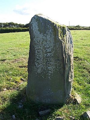
The Ancient Corbalengi Stone
Standing in a field between Penbryn and Tresaith is a tall stone called the Corbalengi Stone. This stone is about 1.4 metres (4.6 feet) high. Experts believe it was placed there around the 6th century, after the Romans left Britain.
The stone has an old inscription that says "CORBALENGI IACIT ORDOVS". The word 'Ordovs' might refer to the Ordovices tribe from North Wales. Some think the stone was made to honor a member of this tribe who lived in the Penbryn area.
Other ideas suggest the inscription means "The Heart of Balengus the Ordovician lies here." Another theory is that "Lacit" (instead of "Iacit") means "thrashed," suggesting a battle between the Ordovices and a group called the "Corbalengi." However, we don't have other records of a "Corbalengi" tribe.
St. Michael's Church: A Historic Landmark
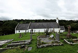
The church of St. Michael is a very old building. It is special because it still has its original medieval slate roof. The church sits on a hill above the sea, which is why the village is called Penbryn, meaning "Hill Head."
The churchyard is round, which suggests it might have been built on an even older, sacred site. The church itself is made from local stone. Its oldest part, the nave, dates back to the 13th century. The chancel was added in the 14th century, and the porch in the 17th century. The church has been repaired and updated a few times over the years.
Smuggling and Trade by the Sea
In the 18th century, Penbryn was a well-known spot for smugglers. They would secretly bring goods ashore here. The wooded valley where the River Hoffnant flows to the beach is even called Cwm Lladron, which means "Robbers' Valley."
The beach was also used by fishing boats and trading ships. These ships brought things like lime from South Pembrokeshire. Lime was used to improve the soil for farming in Ceredigion. However, this trade stopped by the 1860s because the coastline was too dangerous.
Protests Over Payments
During the 19th century, many people in the Penbryn area were Nonconformists. This meant they followed different Protestant religions than the official Church of England.
There were protests in the 1880s and 1890s about payments called "tithes." Tithes were like a tax paid to the church. People who struggled to pay sometimes faced problems. These protests sometimes led to angry crowds.
Penbryn's Geography
Penbryn is located in the valley of the River Hoffnant. This river flows into the sea at Traeth Penbryn.
The wider Penbryn community also includes several other small villages. These are Tre-saith, Brynhoffnant, Glynarthen, Sarnau, and Tan-y-groes.
Traeth Penbryn: The Famous Beach
Traeth Penbryn is a very popular sandy beach. It stretches for about 1.5 miles (2.4 km). The National Trust owns this beautiful beach.
You might recognize it from the James Bond film Die Another Day, where it was used as a filming location. At the north end of the beach, there are several caves to explore. When the tide is low, you can walk along the beach to another large sandy bay. You can also reach Tresaith to the west. Penbryn is part of the Ceredigion Coast Path, which offers steep walking routes along the cliff tops.
Population and Local Government
In 2011, the population of the Penbryn community was 1,270 people. Almost half of them, 49.7%, could speak Welsh. This was a small decrease in Welsh speakers compared to 2001.
Penbryn also has an electoral ward for the Ceredigion council. This ward is a larger area than just the community. It has a total population of 2,045 people.
 | Frances Mary Albrier |
 | Whitney Young |
 | Muhammad Ali |


