Perry, Florida facts for kids
Quick facts for kids
Perry, Florida
|
||
|---|---|---|
| City of Perry | ||

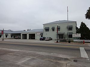
Perry City Hall and Fire Department
|
||
|
||
| Motto(s):
North Florida's Shining Star
|
||

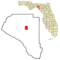
Location in Taylor County and the state of Florida
|
||
| Country | ||
| State | ||
| County | Taylor | |
| Incorporated | 1903 | |
| Government | ||
| • Type | Council-Manager | |
| Area | ||
| • Total | 9.43 sq mi (24.43 km2) | |
| • Land | 9.43 sq mi (24.43 km2) | |
| • Water | 0.00 sq mi (0.00 km2) | |
| Elevation | 46 ft (14 m) | |
| Population
(2024)
|
||
| • Total | 7,417 | |
| • Density | 731.34/sq mi (282.37/km2) | |
| Time zone | UTC-5 (Eastern (EST)) | |
| • Summer (DST) | UTC-4 (EDT) | |
| ZIP codes |
32347-32348
|
|
| Area code(s) | 850 | |
| FIPS code | 12-56150 | |
| GNIS feature ID | 0288724 | |
Perry is a city in Taylor County, Florida, United States. It's also the main town, called the county seat. In 2020, about 6,898 people lived there. The city got its name from Madison Perry. He was the fourth governor of Florida and a Confederate colonel during the American Civil War.
Contents
History of Perry
In 1922, Perry was a very small town. Less than 2,000 people lived there.
In recent years, Perry has faced strong storms. In August 2023, Hurricane Idalia hit Florida. Perry was right in the storm's path and had a lot of damage. Then, in September 2024, Hurricane Helene hit Perry directly. It was a very powerful Category 4 storm.
Geography of Perry
Perry is located at specific coordinates: 30°06′52″N 83°34′57″W / 30.114311°N 83.582609°W.
The city covers a total area of about 9.3 square miles (24 km2). All of this area is land.
Perry is located about 50 miles (80 km) southeast of Tallahassee, Florida's capital city.
Climate in Perry
Perry has a warm climate. Here's a look at the weather patterns:
| Climate data for Perry, Florida, 1991–2020 normals, extremes 1897–present | |||||||||||||
|---|---|---|---|---|---|---|---|---|---|---|---|---|---|
| Month | Jan | Feb | Mar | Apr | May | Jun | Jul | Aug | Sep | Oct | Nov | Dec | Year |
| Record high °F (°C) | 85 (29) |
87 (31) |
90 (32) |
95 (35) |
100 (38) |
103 (39) |
104 (40) |
102 (39) |
99 (37) |
95 (35) |
93 (34) |
89 (32) |
104 (40) |
| Mean maximum °F (°C) | 79.0 (26.1) |
81.2 (27.3) |
85.0 (29.4) |
88.3 (31.3) |
93.7 (34.3) |
96.4 (35.8) |
96.8 (36.0) |
96.2 (35.7) |
94.1 (34.5) |
90.2 (32.3) |
85.2 (29.6) |
80.3 (26.8) |
98.3 (36.8) |
| Mean daily maximum °F (°C) | 66.0 (18.9) |
69.3 (20.7) |
74.5 (23.6) |
79.9 (26.6) |
86.0 (30.0) |
89.2 (31.8) |
90.4 (32.4) |
89.9 (32.2) |
87.7 (30.9) |
81.7 (27.6) |
74.1 (23.4) |
68.3 (20.2) |
79.8 (26.6) |
| Daily mean °F (°C) | 54.7 (12.6) |
57.8 (14.3) |
62.6 (17.0) |
68.1 (20.1) |
74.9 (23.8) |
80.1 (26.7) |
81.8 (27.7) |
81.7 (27.6) |
79.0 (26.1) |
71.3 (21.8) |
62.4 (16.9) |
57.1 (13.9) |
69.3 (20.7) |
| Mean daily minimum °F (°C) | 43.4 (6.3) |
46.4 (8.0) |
50.6 (10.3) |
56.3 (13.5) |
63.9 (17.7) |
71.0 (21.7) |
73.2 (22.9) |
73.5 (23.1) |
70.2 (21.2) |
60.8 (16.0) |
50.7 (10.4) |
46.0 (7.8) |
58.8 (14.9) |
| Mean minimum °F (°C) | 21.9 (−5.6) |
25.2 (−3.8) |
29.1 (−1.6) |
38.0 (3.3) |
48.5 (9.2) |
61.9 (16.6) |
65.9 (18.8) |
66.4 (19.1) |
57.4 (14.1) |
40.0 (4.4) |
29.6 (−1.3) |
25.6 (−3.6) |
20.1 (−6.6) |
| Record low °F (°C) | 7 (−14) |
14 (−10) |
19 (−7) |
29 (−2) |
40 (4) |
46 (8) |
55 (13) |
57 (14) |
42 (6) |
28 (−2) |
14 (−10) |
10 (−12) |
7 (−14) |
| Average precipitation inches (mm) | 4.76 (121) |
3.37 (86) |
4.74 (120) |
3.06 (78) |
3.52 (89) |
7.22 (183) |
7.09 (180) |
8.59 (218) |
4.81 (122) |
2.86 (73) |
2.20 (56) |
2.77 (70) |
54.99 (1,397) |
| Average precipitation days (≥ 0.01 in) | 8.8 | 8.3 | 7.4 | 6.1 | 6.9 | 13.2 | 14.4 | 15.5 | 9.3 | 5.6 | 5.5 | 7.3 | 108.3 |
| Source: NOAA | |||||||||||||
Population and Demographics
The U.S. Census Bureau counts how many people live in an area every ten years. This helps us understand how cities grow and change.
| Historical population | |||
|---|---|---|---|
| Census | Pop. | %± | |
| 1910 | 1,012 | — | |
| 1920 | 1,956 | 93.3% | |
| 1930 | 2,744 | 40.3% | |
| 1940 | 2,668 | −2.8% | |
| 1950 | 2,797 | 4.8% | |
| 1960 | 8,030 | 187.1% | |
| 1970 | 7,701 | −4.1% | |
| 1980 | 8,254 | 7.2% | |
| 1990 | 7,151 | −13.4% | |
| 2000 | 6,847 | −4.3% | |
| 2010 | 7,017 | 2.5% | |
| 2020 | 6,898 | −1.7% | |
| U.S. Decennial Census | |||
Census Data from 2010 and 2020
The tables below show the different groups of people living in Perry. This information helps us see the diversity of the city.
| Race | Pop 2010 | Pop 2020 | % 2010 | % 2020 |
|---|---|---|---|---|
| White (NH) | 3,804 | 3,554 | 54.21% | 51.52% |
| Black or African American (NH) | 2,803 | 2,694 | 39.95% | 39.05% |
| Native American or Alaska Native (NH) | 34 | 26 | 0.48% | 0.38% |
| Asian (NH) | 96 | 153 | 1.37% | 2.22% |
| Pacific Islander or Native Hawaiian (NH) | 1 | 0 | 0.01% | 0.00% |
| Some other race (NH) | 3 | 17 | 0.04% | 0.25% |
| Two or more races/Multiracial (NH) | 124 | 218 | 1.77% | 3.16% |
| Hispanic or Latino (any race) | 152 | 236 | 2.17% | 3.42% |
| Total | 7,017 | 6,898 | 100.00% | 100.00% |
In 2020, there were 6,898 people living in Perry. They lived in 2,443 households, with 1,808 of those being families.
In 2010, there were 7,017 people. They lived in 2,366 households, and 1,618 of those were families.
Education in Perry
Students in Perry go to schools in the Taylor County School District. In the 2007–2008 school year, the Florida Department of Education gave the district a "B" grade. All four schools in the district also earned a "B" grade.
Taylor County High School's football team is called the Bulldogs. They have had some great seasons:
- In 1977–1978, they were Class 3A District 3, Region 2, and State Semi-final Champions. They lost the championship game 7–0.
- The 1978–1979 team won the District 3 championship.
- The 1980–1981 team also won the District 3 championship.
- In 1997–1998, the football team won the Class 3A State Championship!
- In 2010, the Bulldogs had a perfect football season, winning all 10 games. They also won the district championship that year.
Transportation in Perry
Perry has different ways for people to travel.
Perry–Foley Airport is an airport located about 3 miles (4.8 km) south of the city center. It is used by the public.
The city also has a bus service called Perry Shuttle. It is run by Big Bend Transit.
Roads and Highways
Many important roads pass through Perry, connecting it to other places.
Major U.S. Highways
 US 19
US 19 US 27
US 27
 US 27 Alt.
 US 98
US 98 US 221


 US 221 Truck
Law Enforcement in Perry
The Perry Police Department (PPD) keeps the city safe. It has 24 officers.
The department also has four special K-9 teams. These teams include a police officer (handler) and a trained police dog. To become certified, each handler and K-9 partner train for at least 500 hours. Some even train for up to 800 hours!
Notable People from Perry
Many interesting people have come from Perry, Florida. Here are a few:
- LeGarrette Blount, an NFL player
- Ethel Cain, a singer-songwriter and artist
- J. Broward Culpepper, a university administrator
- Victoria Joyce Ely, a World War I veteran and nurse
- O. W. Jones, a politician
- Claude Pepper, a law professor and politician
- Herbert St. John, an NFL player
- Saucy Santana, an American rapper
- Troy Sneed, a gospel singer-songwriter
- Rick Tuten, an NFL player
- C. Bette Wimbish, a civil rights activist and politician
See also
 In Spanish: Perry (Florida) para niños
 | Calvin Brent |
 | Walter T. Bailey |
 | Martha Cassell Thompson |
 | Alberta Jeannette Cassell |


