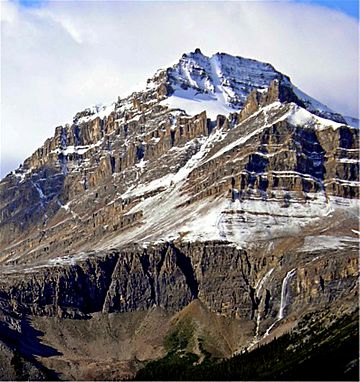
Peyto Peak facts for kids
Quick facts for kids Peyto Peak |
|
|---|---|

Peyto Peak seen from Peyto Lake overlook
|
|
| Highest point | |
| Elevation | 2,980 m (9,780 ft) |
| Prominence | 220 m (720 ft) |
| Parent peak | Mount Baker |
| Listing | Mountains of Alberta |
| Geography | |
| Location | Alberta, Canada |
| Parent range | Waputik Range |
| Topo map | NTS 082N10 |
| Climbing | |
| First ascent | 1933 by Conrad Kain and party |
Peyto Peak is a tall mountain found in the Waputik Range. This range is part of the amazing Canadian Rockies in Alberta, Canada. It sits at the northern end of the Wapta Icefield, which is a huge area of ice and snow.
You can find Peyto Peak inside Banff National Park. It's about one kilometer (0.6 miles) east of the border with British Columbia. The mountain is also about 32 kilometers (20 miles) north of the town of Field.
Just five kilometers northeast of the peak is Bow Pass. This is one of the highest points along the famous Icefields Parkway. A beautiful place called Peyto Lake lies between the peak and the pass. About three kilometers southwest of Peyto Peak is Mount Baker, which is the tallest mountain nearby.
Mountain History: How Peyto Peak Got Its Name
Peyto Peak was named in 1896 by a person named Walter Wilcox. He named it after Ebenezer William "Bill" Peyto. Bill Peyto was an early "outfitter," which means he helped people get ready for trips into the wilderness. He was also a "trail guide" who led people on paths and a "trapper" who caught animals for their fur. He worked in the Banff and Lake Louise areas.
The first time anyone successfully climbed to the top of Peyto Peak was in 1933. This climb was done by a very famous mountaineer named Conrad Kain and his team. The mountain's name officially became recognized in 1928 by the Geographical Names Board of Canada.
Understanding Peyto Peak's Geology
Just like other mountains in Banff Park, Peyto Peak is made of a type of rock called sedimentary rock. This rock formed a very, very long time ago, from the Precambrian to the Jurassic periods. These periods cover hundreds of millions of years.
This sedimentary rock was formed in shallow seas that once covered the area. Later, during a huge mountain-building event called the Laramide orogeny, these rocks were pushed up. They were pushed east and even over the top of younger rock layers. This process created the towering mountains we see today.
Peyto Peak's Climate and Weather
Peyto Peak is located in a subarctic climate zone. This means it has very cold, snowy winters and mild summers. Temperatures can often drop below -20 °C (which is -4 °F). With the wind chill, it can feel even colder, sometimes below -30 °C (-22 °F).
The snow and rain that fall on Peyto Peak eventually melt and flow away. This water is called runoff. It drains into the Mistaya River. The Mistaya River is a "tributary," meaning it's a smaller river that flows into a larger one. In this case, it flows into the Saskatchewan River.
 | Anna J. Cooper |
 | Mary McLeod Bethune |
 | Lillie Mae Bradford |


