Piamonte facts for kids
Quick facts for kids
Piamonte
|
||
|---|---|---|
|
Municipality and town
|
||
 |
||
|
||

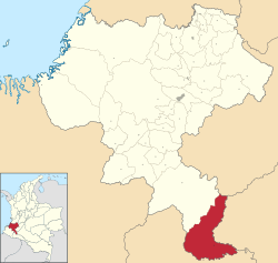
Location of the municipality and town of Piamonte in the Cauca Department of Colombia.
|
||
| Country | ||
| Department | Cauca Department | |
| Founded | 2 July 1959 | |
| Founded by | Aristides Pérez | |
| Elevation | 300 m (1,000 ft) | |
| Population
(2020)
|
||
| • Total | 9,259 | |
| Time zone | UTC-5 (Colombia Standard Time) | |
| Climate | Af | |
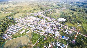
Piamonte is a town and municipality in the Cauca Department, Colombia. It was founded in 1959 as part of the Santa Rosa municipality.
Many people moved to Piamonte over the years. They came from different parts of Colombia. At first, they were drawn by the chance to find quinine in the 1930s. Later, some were displaced by conflict in the 1950s and 1960s. More recently, people came because of the oil industry. The area is also home to members of the Inga indigenous community. Piamonte officially became its own municipality in 1996.
Piamonte shares borders with several other areas. To the north, it borders the Huila Department and the Santa Rosa municipality. To the east, it borders the Caquetá Department. To the west, it borders Santa Rosa and the Caquetá River. To the south, it borders the Putumayo Department.
Contents
History of Piamonte
The town of Piamonte was started in 1959 by a group of settlers. Their leader was Aristides Perez. The place was then known as La Barbasca.
In 1966, some local leaders wanted Piamonte to become separate from the municipality of Santa Rosa. This idea became real years later. It happened when oil companies started working in the region in the early 1990s. Piamonte was officially recognized as a municipality on November 18, 1996.
The area, known as Baja Bota, grew slowly at first. The first known settlements were in the 1930s. Among them were the Inganos people in Guayuyaco. They had likely moved from the Putumayo area.
Nápoles is the oldest local inspection area. It was settled by people from Nariño. They came along an important path now called the Carretera Marginal de la Selva (Peripheral Road of the Jungle). In the early 1970s, Nápoles had to move. A flood from the Caquetá River damaged much of the town.
By the 1950s, new roads were opened from the main path. These roads led deeper into the area. The first ones in Piamonte were along the Tambor, Miraflor, and Campoalegre rivers. They also followed the Guayuyaco and Nabueno rivers. This means the oldest settlements are in the higher parts of the area, near the main path.
Over time, two main areas formed based on where people came from. The area to the east was influenced by Caquetá. People settled there from San José del Fragua, Yurayaco, and Fragüita. They spread along the Fragua, Congor, and Tambor rivers.
The people who came from the west were mostly from Nariño and Putumayo. They moved through the Mocoa River valley to the Caquetá River. This movement grew when new roads were built. Today, most people in Baja Bota Caucana are settlers. They own their homes and land, but often don't have official legal titles.
Piamonte became a municipality between 1994 and 1996. This happened because local people felt ignored by the government. They believed they were not getting enough support or benefits from the oil found in their region.
Geography of Piamonte
Piamonte is located in the southwest of the Cauca Department. This area is called the Baja Bota Caucana because of its map shape. It is a special place where the Pacific coast, the Andes mountains, and the Amazon rainforest meet.
Piamonte's location is very important. It is a key transit area and border between four departments. These departments are part of the Colombian Massif region, which is a major source of water. Biologically, Piamonte is where the Central Cordillera, Eastern Cordillera, Amazon, Magdalena Valley, and the eastern side of the Andes come together. This makes it a natural "jungle corridor."
In South America, this part of the Amazon is special. It is only about 335 km (208 miles) from the Pacific Ocean. This is the shortest distance between the Pacific Ocean and the Amazon in all of South America. Piamonte is part of the Amazon basin. This area is known for its many different plants and animals, its water resources, oil, and ancient cultures.
Economy of Piamonte
Piamonte's economy relies on natural resources. These include cinchona, rubber, wood, oil, and coca. People also grow crops for their own use. These traditional crops include banana, cassava, corn, and chontaduro. Amazonian fruits like arazá, borojó, and caimarón grape are also grown.
Piamonte is a center for development. One of its goals is to help coordinate the region and make it easier to transport goods. As an Amazon region, Piamonte has oil underground. This oil is found across southern Colombia, parts of Ecuador, and Peru. Oil companies are currently extracting this oil.
In Piamonte, the company Argosy Energy International (part of Canadian Gran Tierra Energy) has explored and extracted oil from five wells. These wells are Mary 1, Mary 2, Mary 3, Mary 5, and Miralor 1. This happened from 1993 to 2008. Gran Tierra Energy Inc. continues to extract oil today. In 2002, oil production was 2,290 barrels per day. About three million barrels of oil reserves have been found.
Large private companies are the main employers in Piamonte. Gran Tierra Company has facilities in the villages of La Honda, Rosario, El Morro, and Florida West. Betra Company has facilities in Piamonte itself. Petronova is in La Samaritana village, and Oilgrass explores around Piamonte.
By law, Piamonte should receive a portion of the money from oil production. This money is called royalties. It should be used for social projects, like improving electricity and sanitation. However, many parts of the region still lack these basic services. Only the main towns of Piamonte and Miraflor have recently gotten electricity. Even with all these resources, the people of Piamonte have not seen much improvement in their living conditions.
Piamonte is also known as a transit point. Many people move through it from nearby departments like Putumayo, Caquetá, and Huila. They might be moving because of conflict, looking for wealth, or searching for land to farm. Because of this, Piamonte is a multicultural municipality with a diverse population. It has strong business ties with nearby towns in Caquetá and Putumayo. These include Curillo, San José del Fragua, Belén de los Andaquíes, Villagarzón, and Mocoa.
Communications
The Carretera Marginal de La Selva (Peripheral Road of the Jungle) goes through Piamonte. This road is part of a bigger plan to connect all of South America with roads. From Piamonte, this road connects to Villagarzón and Puerto Asís towards Ecuador. It also connects from Villagarzón towards Pasto and Tumaco.
Population of Piamonte
The municipality of Piamonte is home to people from different parts of Colombia. These include settlers from the departments of Caquetá, Putumayo, Nariño, and Cauca. It also has indigenous peoples, with 12.24% being from the Inga ethnic group. There is also a notable percentage of Afro-descendant people.
As of 2012, Piamonte had 7,241 people. About 8.29% (600 people) live in the main town. The remaining 91.71% (6,641 people) live in the rural areas. There are 69 villages in total.
The indigenous population is organized into 9 councils recognized by indigenous authorities:
- Bajo Chuspizacha
- San Gabriel
- Alto Suspizacha
- Rumiñawi
- San Jose del Inchiyaco
- Ambiwasi
- Musurrunacuna
- Caucapapungo
- Aukawasi
There are also 6 legally recognized reservations for the Inga community:
- Guayuyaco
- Inga Wasipanga
- La Floresta Española
- La Leona
- Las Brisas
- San Rafael
Administrative Divisions of Piamonte
Piamonte is divided into different areas called corregimientos and veredas (inspections).
| Corregiment | Veredas (Inspections) | # of Veredas |
| Piamonte | EL Convenio, San Isidro, El Jardin, La Sonora, Puerto Bello, Santa Rita, La Vega, San Jorge, Piamonte, Nueva Esperanza | 9 |
| El Remanso | Villalozada, Las Perlas, El Morro, Las Delicias, Playa Rica, Puerto Miranda, El Remanso, La Libertad | 7 |
| Miraflor | Buenos Aires, Sevilla, EL Rosal, San Pablo, La Palmera, La Floresta, Campoalegre, Nabueno, El Cerrito, La Segovia, La Gaviota, La Esmeralda, Bajo Inchiyaco, La Española, Miraflor, La Floresta Española | 15 |
| Yapurá | Angosturas, Bututo, Villanueva, Palmito, La Consolata, Yapurá | 5 |
| Nápoles | Baja Primavera, El Edén, La Guajira, La Florida, Nápoles | 4 |
| EL Cedro | El Vergel, El Caraño, Trojayaco, La Samaritana, Villa del Prado, Los Almendros, El Cedro | 6 |
| El Bombonal | La Leona, Brasilia, El Bombonal, Puerto Bello, La Isla | 4 |
| Bajo Congor | El Diamante, La Cabaña, El Triunfo Congor, La Tigra, Bajo Congor | 4 |
| Fragua VIejo | EL Porvenir, San Gabriel, El Sinaí, Los Pios, Fragua Viejo, Reservation San Rafael | 5 |
Climate of Piamonte
Piamonte has a tropical rainforest climate. This means it has hot temperatures, high humidity, and a lot of rain all year round.
| Climate data for Piamonte | |||||||||||||
|---|---|---|---|---|---|---|---|---|---|---|---|---|---|
| Month | Jan | Feb | Mar | Apr | May | Jun | Jul | Aug | Sep | Oct | Nov | Dec | Year |
| Mean daily maximum °C (°F) | 30.7 (87.3) |
30.4 (86.7) |
29.9 (85.8) |
29.5 (85.1) |
29.3 (84.7) |
28.9 (84.0) |
28.8 (83.8) |
29.6 (85.3) |
30.0 (86.0) |
30.4 (86.7) |
30.3 (86.5) |
30.4 (86.7) |
29.9 (85.7) |
| Daily mean °C (°F) | 25.7 (78.3) |
25.5 (77.9) |
25.3 (77.5) |
25.0 (77.0) |
24.9 (76.8) |
24.6 (76.3) |
24.3 (75.7) |
24.7 (76.5) |
25.1 (77.2) |
25.4 (77.7) |
25.5 (77.9) |
25.6 (78.1) |
25.1 (77.2) |
| Mean daily minimum °C (°F) | 20.8 (69.4) |
20.7 (69.3) |
20.7 (69.3) |
20.6 (69.1) |
20.5 (68.9) |
20.3 (68.5) |
19.9 (67.8) |
19.9 (67.8) |
20.3 (68.5) |
20.5 (68.9) |
20.8 (69.4) |
20.9 (69.6) |
20.5 (68.9) |
| Average rainfall mm (inches) | 230 (9.1) |
247 (9.7) |
367 (14.4) |
418 (16.5) |
444 (17.5) |
461 (18.1) |
418 (16.5) |
301 (11.9) |
322 (12.7) |
341 (13.4) |
341 (13.4) |
267 (10.5) |
4,157 (163.7) |
| Source: Climate-Data.org | |||||||||||||
Places to Visit
The Serranía de Los Churumbelos Auka-Wasi National Natural Park is located in the mountainous part of the municipality. It's a great place to explore nature.
See also
In Spanish: Piamonte (Cauca) para niños
 | Jessica Watkins |
 | Robert Henry Lawrence Jr. |
 | Mae Jemison |
 | Sian Proctor |
 | Guion Bluford |


