
Pica Peak facts for kids
Quick facts for kids Pica Peak |
|
|---|---|

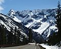
Pica Peak, northeast aspect
|
|
| Highest point | |
| Elevation | 7,565 ft (2,306 m) |
| Prominence | 125 ft (38 m) |
| Isolation | 0.75 mi (1.21 km) |
| Parent peak | Blue Lake Peak (7,840 ft) |
| Geography | |

Pica Peak
Location in Washington (state)

Pica Peak
Location in the United States
|
|
| Location | Okanogan / Chelan counties Washington state, U.S. |
| Parent range | North Cascades Cascade Range |
| Topo map | USGS Washington Pass |
| Climbing | |
| Easiest route | class 3 scrambling |
Pica Peak is a mountain peak that stands 7,565-foot (2,306-metre) tall. It is located in the Methow Mountains, which are part of the larger North Cascades mountain range. This peak sits right on the border between Okanogan County and Chelan County in Washington state.
Pica Peak is about 1.7 mi (2.7 km) southeast of Washington Pass. It is also found within the Okanogan-Wenatchee National Forest. The closest taller mountain is Copper Benchmark, which is 0.58 miles (0.93 km) to the southeast. Blue Lake Peak is 0.93 miles (1.50 km) to the west-northwest. Even though Pica Peak isn't the tallest, it rises sharply by 2,000 feet from the Early Winters Basin in just 0.5 mi (1 km). Water from the north side of the mountain flows into the Methow River. Water from the south side flows into streams that lead to the Stehekin River.
What is the Weather Like?
Most weather systems begin over the Pacific Ocean. They then travel northeast towards the Cascade Mountains. As these weather systems reach the North Cascades, the tall mountains force the air upward. This process, called orographic lift, makes the air cool down and drop its moisture. This moisture falls as rain or snow.
Because of this, the western side of the North Cascades gets a lot of rain and snow, especially in winter. Winters are usually cloudy. However, in summer, high-pressure systems over the Pacific Ocean often bring clear skies. The best time to visit or climb Pica Peak is from July through September, when the weather is usually sunny and mild.
How Was Pica Peak Formed?

The North Cascades have some of the most rugged and dramatic landscapes. You can see sharp peaks, long ridges, and deep valleys carved by glaciers. These amazing features and the big changes in elevation were created by geological events that happened millions of years ago. These events also led to the different climates we see across the Cascade Range.
The Cascade Mountains started forming millions of years ago, during a time called the late Eocene Epoch. This happened when the North American Plate slowly moved over the Pacific Plate. This movement caused many volcanic eruptions. Also, small pieces of the Earth's crust, called terranes, came together to form the North Cascades about 50 million years ago.
During the Pleistocene period, which was over two million years ago, huge sheets of ice called glaciers moved across the land. They carved out the landscape, leaving behind rock and debris. The valleys that rivers flow through today often have a "U" shape. This shape was created by these ancient glaciers. The combination of the land being pushed up (called uplift) and cracks forming in the Earth's crust (called faulting), along with the glaciers, created the tall peaks and deep valleys of the North Cascades.
Images for kids
-
Pica in upper left corner
-
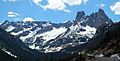
Pica Peak at left edge, from North Cascades Highway


