
Blue Lake Peak facts for kids
Quick facts for kids Blue Lake Peak |
|
|---|---|

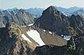
Blue Lake Peak seen from the North Cascades Highway
|
|
| Highest point | |
| Elevation | 7,800 ft (2,377 m) |
| Prominence | 640 ft (200 m) |
| Isolation | 0.39 mi (0.63 km) |
| Parent peak | Wallaby Peak (7,995 ft) |
| Geography | |

Blue Lake Peak
Location in Washington (state)

Blue Lake Peak
Location in the United States
|
|
| Location | Border of Chelan and Skagit Counties, Washington, United States |
| Parent range | North Cascades |
| Topo map | USGS Washington Pass |
| Climbing | |
| First ascent | September 28, 1946 by Fred Beckey, Jerry O'Neil, Charles Welsh |
| Easiest route | Scrambling |
Blue Lake Peak is a mountain in the North Cascades mountain range. It is located in the state of Washington, in the United States. This peak is about 7,800 feet (2,377 meters) tall.
The mountain is found within the Okanogan National Forest. It sits right on the border between Okanogan County and Chelan County. Blue Lake Peak is south of other famous peaks like Liberty Bell Mountain.
You can see Blue Lake Peak from the North Cascades Highway. There is a special spot called the Blue Lake Trailhead. A beautiful lake, called Blue Lake, is located below the mountain's west side. Water flowing from Blue Lake Peak eventually reaches the Chelan River and Methow River.
What is the Weather Like on Blue Lake Peak?

Most of the weather in this area comes from the Pacific Ocean. These weather systems travel northeast towards the Cascade Mountains. When they reach the tall peaks of the North Cascades, the air is forced to rise. This process is called Orographic lift.
As the air rises, it cools down and drops its moisture. This moisture falls as rain or snowfall on the mountains. Because of this, the western side of the North Cascades gets a lot of rain and snow. This is especially true during the winter months.
The snow here tends to be wet and heavy. This can create a high risk of avalanches. During winter, the weather is often cloudy. However, in summer, high-pressure systems over the Pacific Ocean bring clear skies. The best time to visit or climb Blue Lake Peak is from July to September.
How Did Blue Lake Peak Form?

The North Cascades mountains have very rugged and sharp peaks. They also have deep valleys carved by glaciers. These amazing shapes were created by geological events over millions of years. These events also caused big changes in elevation. This led to different climates and types of plants in the area.
The Cascade Range began forming millions of years ago, during the late Eocene Epoch. This was a time when the North American Plate was slowly moving over the Pacific Plate. This movement caused many volcanic eruptions.
Also, small pieces of the Earth's crust, called terranes, joined together. This process helped create the North Cascades about 50 million years ago.
During the Pleistocene period, which started over two million years ago, glaciers played a big role. These huge sheets of ice moved forward and backward many times. As they moved, they scraped and shaped the land. They left behind piles of rock and debris.
The "U"-shaped valleys you see today were carved by these glaciers. The combination of land being pushed up (called uplift) and cracks in the Earth's crust (called faulting) has shaped the tall peaks and deep valleys of the North Cascades.
Images for kids
-
Blue Lake Peak from Early Winters Spires

