
Planoise facts for kids
Quick facts for kids
Planoise
|
|
|---|---|
|
Part of Besançon
|
|

Top: Planoise from Rosemont Hill.
Centre: the tower of Planoise; Époisses sector; the Diversity statue. Bottom: View from the hill of Planoise. |
|

Planoise
Location in France

Planoise
Location in Bourgogne-Franche-Comté
|
|
| Country | France |
| Region | Bourgogne-Franche-Comté |
| Department | Doubs |
| Arrondissement | Besançon |
| Canton | Besançon-1 |
| Commune | Besançon |
| Area
1
|
2.5 km2 (1.0 sq mi) |
| Population
(January 2006)
|
21,000 |
| • Density | 8,400/km2 (21,800/sq mi) |
| Time zone | UTC+01:00 (CET) |
| • Summer (DST) | UTC+02:00 (CEST) |
| Website | http://planoise-forever.skyrock.com/ |
| 1 French Land Register data, which excludes lakes, ponds, glaciers > 1 km2 (0.386 sq mi or 247 acres) and river estuaries. | |

Planoise is a lively urban area located in the western part of Besançon, France. It was built in the 1960s between the Planoise hill and the Hauts-de-Chazal district. Planoise is the most populated area in Besançon, with about 21,000 people living there. This means about 17% of Besançon's total population calls Planoise home! The people who live here are called Planoisiens (for boys and men) and Planoisiennes (for girls and women).
Planoise is always changing and growing. It has become a busy place for shopping and is home to people from over 50 different cultures. This makes it a very diverse and interesting community. Even though it's a very urban area with many buildings, it has some special spots. These include the Departmental archives of Doubs, which store important historical documents, and the unique Statue of Diversity.
Contents
A Look Back: The History of Planoise
The very first signs of people living in Planoise go back a long, long time ago. This was around 3000 BCE, during a period called the Middle Paleolithic era. Scientists found old objects in the Epoisses area. These included a flint point from the Middle Paleolithic. They also found three bracelets from the end of the Iron Age (around 500 BCE). An oil lamp from ancient Greece (between 400 and 100 BCE) was also discovered. These amazing finds are kept safe at the Musée des Beaux-Arts et d'archéologie de Besançon (Museum of Fine Arts and Archeology).
In the 1200s, Planoise officially became part of the Imperial city of Besançon. This happened thanks to Jean de Chalon, who was an earl of Burgundy. Later, in the 1400s, the church leaders of Besançon bought the land and the hill of Planoise. The name "Planoise" first appeared in official records in 1435. The name comes from a Latin word, "planesium," which means "plain." Back then, the area was mostly a big forest with only a few farmers living there.
Between the Middle Ages and more modern times, Planoise remained mostly empty. It was mainly used for farming, especially growing potatoes. In 1815, the prince of Liechtenstein wanted to take over the city of Besançon. He sent an army, but they were stopped at Planoise. Because of this, they gave up their plan to capture the city.
At the start of the 1900s, many farms were built in the area. As more people moved in, farming became a very important part of the local economy. The First and Second World Wars did not greatly affect Planoise. However, one American soldier was sadly killed there. By the late 1950s, Planoise began to transform into a new urban area of Besançon.
Big construction projects started in 1962. About 13,000 new homes were built in Planoise, and this work continued until 1985. The first families moved into these new buildings in 1968.
In the early 1970s, the first shops were built. The church of Planoise was finished in 1972. Soon after, the Diderot school was built, and the Cassin area grew. This time is often called the "golden age" of Planoise. By 1977, the population had grown to 12,000 people.
Where is Planoise?

Planoise is located in the western part of Besançon. It is part of the Canton of Besançon-1. To the west, Planoise borders Franois and Grandfontaine. To the north, it's next to Pirey. To the east, you'll find Saint-Ferjeux and the center of Besançon. To the south, it borders Velotte and Avanne-Aveney.
The area sits on a flat plain that is about 300 hectares (or 740 acres) in size. It's nestled between the Planoise hill (which is 490 meters high) and the Rosemont hill (466 meters high). The Doubs river is also very close, just one kilometer away. Two large woods surround the neighborhood: the "Monsieur" wood and the Pirey wood.
The main road in Planoise is Dole street. This is also a major road for Besançon itself. The west boulevard connects Planoise to the Velotte area. In the center of Planoise, important roads include Île-de-France avenue, Bourgonge road, and Franche-Comté street.
Nature and Wildlife in Planoise
Even though Planoise is an urban area, it has a lot of green spaces and a rich natural environment. You can find many trees along the streets, especially beeches, firs, Aesculus (horse chestnut trees), and birches.
The urban park of Planoise is a lovely wooded park. It has playgrounds where kids can have fun. This park is located in the Cassin area. The city is planning to build even more new playgrounds there!
The wood of Planoise, located on the Planoise hill, is home to many different animals and plants. You might spot foxes, wild boars, squirrels, and various birds. The trees include beeches, firs, aesculus, oaks, and Platanus (plane trees). There are also many ferns. A network of trails makes it easy to explore the wood and reach the old Fort of Planoise. The only new structure built in the wood is the Water tower of Planoise.
-
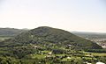
The hill of Planoise
-
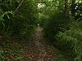
A trail in the woods
-
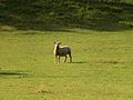
A sheep near Malcombe sector
-
The urban park


Images for kids
-
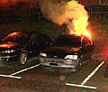
A car in Planoise
-
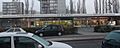
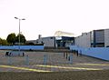
The Île-de-France mall
-
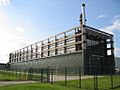
Municipal wood boiler
-
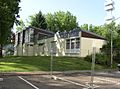
Church of Francis of Assisi
-
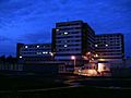
Jean Minjoz Hospital at night
-
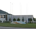
Lafayette Ice Rink and Swimming Pool
-
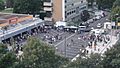
Music festival in Epoisses sector
-
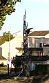
The "Statue of Diversity"
-
Statue at Tristan Bernard school
-
The "statue of the world"
-
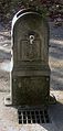
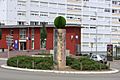
Epoisses fountain
-
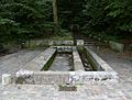
Old laundry building of Planoise
-
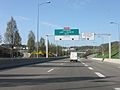
Entering Planoise
-

Graffiti art in Planoise
-
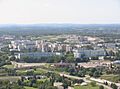
General view of Planoise from Rosemont hill
-
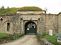
Main entrance of the Fort of Planoise
-
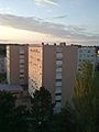
Buildings in the Ile-de-France sector


_-Besan%C3%A7on.JPG)


See also
 In Spanish: Planoise para niños
