Pomfret, Vermont facts for kids
Quick facts for kids
Pomfret, Vermont
|
|
|---|---|

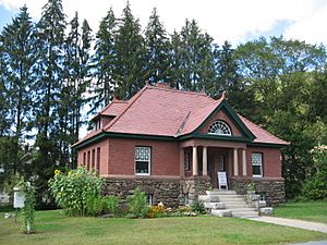
Abbott Memorial Library in South Pomfret
|
|

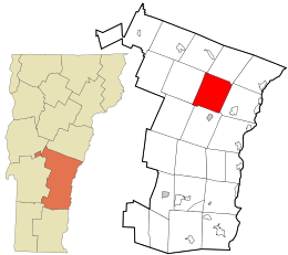
Location in Windsor County and the state of Vermont.
|
|
| Country | United States |
| State | Vermont |
| County | Windsor |
| Communities |
|
| Area | |
| • Total | 39.5 sq mi (102.2 km2) |
| • Land | 39.4 sq mi (102.0 km2) |
| • Water | 0.1 sq mi (0.2 km2) |
| Elevation | 1,499 ft (457 m) |
| Population
(2020)
|
|
| • Total | 916 |
| • Density | 23.19/sq mi (8.963/km2) |
| Time zone | UTC-5 (Eastern (EST)) |
| • Summer (DST) | UTC-4 (EDT) |
| ZIP Codes |
05053 (North Pomfret)
05067 (South Pomfret) 05068 (South Royalton) 05084 (West Hartford) 05091 (Woodstock) |
| Area code(s) | 802 |
| FIPS code | 50-56350 |
| GNIS feature ID | 1462177 |
Pomfret is a small town located in Windsor County, Vermont, United States. In 2020, about 916 people lived there. It's a quiet place with a rich history and beautiful natural surroundings.
Contents
History of Pomfret
The town of Pomfret was officially created in 1761 by Benning Wentworth. He was the governor of New Hampshire at the time. The town was named after the Earl of Pomfret.
The first person to settle in Pomfret was Bartholomew Durkee in 1770. He came from a town also named Pomfret in Connecticut. Because many early settlers came from that Connecticut town, Pomfret, Vermont, was first called "New Pomfret."
An important part of winter sports history happened in South Pomfret. One of the very first ski tows in the United States was built there in 1934. This helped people enjoy skiing more easily.
In 1976, a special visitor came to North Pomfret for a summer vacation. This was Karol Wojtyla, who was a cardinal at the time. He later became Pope John Paul II, a very important leader of the Catholic Church. He was later recognized as a saint.
Geography of Pomfret
Pomfret covers an area of about 39.5 square miles (102.2 square kilometers). Most of this area is land, with only a small amount of water.
The Ottauquechee River flows along part of the southern edge of the town. The Pomfret town hall is located in the middle of the town. It sits on a "watershed divide," which means it's on high ground where water flows in different directions. Water from one side goes towards the White River (near North Pomfret), and water from the other side flows towards the Ottauquechee River (near South Pomfret).
People of Pomfret
| Historical population | |||
|---|---|---|---|
| Census | Pop. | %± | |
| 1790 | 710 | — | |
| 1800 | 1,106 | 55.8% | |
| 1810 | 1,433 | 29.6% | |
| 1820 | 1,635 | 14.1% | |
| 1830 | 1,867 | 14.2% | |
| 1840 | 1,774 | −5.0% | |
| 1850 | 1,546 | −12.9% | |
| 1860 | 1,376 | −11.0% | |
| 1870 | 1,251 | −9.1% | |
| 1880 | 1,139 | −9.0% | |
| 1890 | 865 | −24.1% | |
| 1900 | 777 | −10.2% | |
| 1910 | 703 | −9.5% | |
| 1920 | 732 | 4.1% | |
| 1930 | 728 | −0.5% | |
| 1940 | 686 | −5.8% | |
| 1950 | 586 | −14.6% | |
| 1960 | 600 | 2.4% | |
| 1970 | 620 | 3.3% | |
| 1980 | 856 | 38.1% | |
| 1990 | 874 | 2.1% | |
| 2000 | 997 | 14.1% | |
| 2010 | 904 | −9.3% | |
| 2020 | 916 | 1.3% | |
| U.S. Decennial Census | |||
According to the 2000 census, there were 997 people living in Pomfret. These people lived in 404 households, and 288 of these were families. The town had about 25 people per square mile.
Many households (about 33%) had children under 18 living with them. Most households (about 61%) were married couples living together. About 22% of all households were individuals living alone. The average household had about 2.5 people.
The median age in Pomfret was 42 years old. This means half the people were younger than 42, and half were older.
Famous People From Pomfret
Many interesting people have connections to Pomfret, Vermont. Here are a few:
- Elmer B. Adams – A judge for the U.S. government.
- William Arkin – A writer, activist, and journalist who comments on politics.
- Judah Dana – A U.S. senator who represented the state of Maine.
- Rush Hawkins – A general who fought for the Union during the American Civil War.
- Luke S. Johnson – An important leader in the early Latter Day Saint movement.
- Lyman E. Johnson – Also a leader in the Latter Day Saint movement.
- Scott Milne – A businessman and a political candidate.
- Joe Perry – The famous guitarist for the rock band Aerosmith.
- John C. Sherburne – A Chief Justice of the Vermont Supreme Court.
- Dana Stone – A journalist and photographer who covered the Vietnam War.
- John Throop – An early resident of Pomfret who was a militia officer and a judge.
- Phineas White – A person who served as a United States Representative.
See also
 In Spanish: Pomfret (Vermont) para niños
 | Roy Wilkins |
 | John Lewis |
 | Linda Carol Brown |


