
Ponte Tresa facts for kids
Quick facts for kids
Ponte Tresa
|
||
|---|---|---|

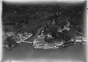
Ponte Tresa village
|
||
|
||

Ponte Tresa
Location in Switzerland

Ponte Tresa
Location in Canton of Ticino
|
||
| Country | Switzerland | |
| Canton | Ticino | |
| District | Lugano | |
| Area | ||
| • Total | 0.41 km2 (0.16 sq mi) | |
| Elevation | 277 m (909 ft) | |
| Population
(December 2019)
|
||
| • Total | 773 | |
| • Density | 1,885/km2 (4,880/sq mi) | |
| Postal code |
6988
|
|
| Surrounded by | Caslano, Croglio, Lavena, Lavena Ponte Tresa (Italy) | |

Ponte Tresa (called Pont da Tresa in the Ticinese dialect) was a town in Switzerland. It was located in the Ticino area, near the city of Lugano. On April 18, 2021, Ponte Tresa joined with three other towns: Croglio, Monteggio, and Sessa. Together, they formed a new, larger town called Tresa.
Contents
A Look at Ponte Tresa's History
Ponte Tresa was first mentioned in old writings around the year 818. Back then, it was called ad Tresiae Pontem. Later, in 875, it was known as Ponte Tretia. For a while, it also had a German name, Treisbruck, but this name is not used anymore.
The story of Ponte Tresa is very connected to the Tresa river. This river crossing was first talked about in the year 590. Both Ponte Tresa and the nearby Italian town, Lavena Ponte Tresa, get their names from this river.
From the Middle Ages until 1847, Ponte Tresa was a very important place. It offered key connections between Switzerland and Italy. Even during the Roman times, there was likely a bridge or a shallow spot to cross the river here.
During the Middle Ages and later, the bridge was made of wood with stone supports. Underneath the bridge, there were fish ponds. These ponds were mostly used to raise eels, which belonged to the Bishop of Milan. In the 1500s, local noble families owned the bridge. It stayed with the de Stoppani family until 1828, when the Ticino area bought it. The Ticino area then built a new stone bridge in 1846. The bridge you see today was built in 1962.
Above the town, in an area called Rocchetta, you can find the ruins of an old castle. This castle was called S. Martino and was built by the Comacine masters. It was destroyed during a war between two Italian cities, Como and Milan, from 1118 to 1127.
In the Middle Ages, Ponte Tresa had special jobs and rights. These included controlling the border, collecting tolls for using the bridge, and keeping the bridge in good shape. The Duke of Milan even allowed the village to not pay certain taxes. The Swiss Confederation later confirmed this tax break in the 1400s.
The village church used to be part of the Lavena Ponte Tresa church until 1821. After that, it became its own separate church. The church of S. Bernardino was built in the 1400s and was updated between 1972 and 1982. The railway connecting Lugano to Ponte Tresa started running in 1912.
Exploring Ponte Tresa's Geography

Ponte Tresa covered an area of about 0.41 square kilometers (0.16 square miles). A good portion of this land, about 34.1%, was used for farming. Forests covered about 43.9% of the area. The rest of the land, about 46.3%, had buildings or roads on it. A small part, about 7.3%, was made up of rivers or lakes.
Most of the built-up area, about 31.7%, was for houses and other buildings. Roads and other transport areas made up 9.8%. Parks and sports fields covered 4.9%. All the forested land was covered with thick forests. For farming, 2.4% was used for growing crops, and 31.7% was for mountain pastures. All the water in the town was flowing water, like rivers.
The former town is located in the Lugano area, right on Lake Lugano. It sits along the border between Switzerland and Italy. It is about 12 kilometers (7.5 miles) from Lugano. The Italian town next door is called Lavena Ponte Tresa.
Understanding the Coat of Arms
The coat of arms for Ponte Tresa has a special design. It is split into two parts: red on top and silver on the bottom. There are four blue stripes. A gold bridge with five arches sits on the line that divides the colors. On top of the bridge is a black mule. In the water below, there are three black eels swimming.
Ponte Tresa's Population and People
Ponte Tresa had a population of 773 people in 2019. In 2008, about 27.3% of the people living there were not Swiss citizens. Over ten years, from 1997 to 2007, the population grew by 3.5%.
Most people in Ponte Tresa speak Italian, about 79.8% of the population. German is the second most common language, spoken by 13.3% of the people. About 2.6% of the population speaks French. In 2000, 102 people spoke German, 20 spoke French, 614 spoke Italian, and 4 spoke Romansh. The remaining 29 people spoke other languages.
In 2008, about 45.6% of the population was male, and 54.4% was female. There were 251 Swiss men and 117 non-Swiss men. There were 332 Swiss women and 107 non-Swiss women.
The age groups in Ponte Tresa in 2009 were:
- Children (0-9 years old): 50 people (6.2%)
- Teenagers (10-19 years old): 76 people (9.4%)
- Young adults (20-29 years old): 60 people (7.4%)
- Adults (30-39 years old): 108 people (13.4%)
- Adults (40-49 years old): 154 people (19.1%)
- Adults (50-59 years old): 99 people (12.3%)
- Seniors (60-69 years old): 106 people (13.1%)
- Seniors (70-79 years old): 99 people (12.3%)
- Seniors (over 80 years old): 55 people (6.8%)
In 2000, there were 373 homes in Ponte Tresa, with about 2 people living in each home on average. Most homes had 3 rooms. About 67.6% of the apartments were lived in all the time.
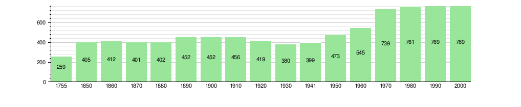
The chart below shows how the population of Ponte Tresa has changed over many years:
Getting Around Ponte Tresa

Ponte Tresa has its own train station, Ponte Tresa station. This station is on the Lugano–Ponte Tresa railway, which is a narrow-gauge railway that connects to Lugano. Trains run often, every 15 minutes during the day on weekdays, and every half-hour at other times.
The train station is also a stop for Autopostale buses. These buses can take you to places like Luino, Monteggio, and Novaggio. In the summer, you can also take a boat from the village. The Società Navigazione del Lago di Lugano offers boat services to and from Lugano.
Ponte Tresa's Economy and Jobs

In 2007, the unemployment rate in Ponte Tresa was 5.4%. In 2005, there were 34 people working in the secondary sector (like manufacturing) and 5 businesses in this area. The tertiary sector (services, like shops and offices) employed 235 people, with 56 businesses.
There were 332 people living in Ponte Tresa who had jobs. About 44.3% of these workers were women. In 2000, 328 workers came into Ponte Tresa for their jobs, while 250 workers left to work elsewhere. This means more people came into Ponte Tresa for work than left. About 20.1% of the workers coming into Ponte Tresa were from outside Switzerland. Of the working population, 16% used public transport to get to work, and 55.7% used a private car. In 2009, there were 2 hotels in Ponte Tresa.
Religious Life in Ponte Tresa
Based on the 2000 census, most people in Ponte Tresa were Roman Catholic, about 78.7%. About 7.7% belonged to the Swiss Reformed Church. There were also 81 people (about 10.53%) who belonged to other churches not listed in the census. About 3.12% of the people did not answer the question about their religion.
Weather in Ponte Tresa
Ponte Tresa usually has about 103.8 days of rain or snow each year. On average, it gets about 1806 millimeters (71 inches) of precipitation. The wettest month is May, when Ponte Tresa gets about 226 millimeters (8.9 inches) of rain. It rains for about 13.4 days in May. The driest month is December, with about 70 millimeters (2.8 inches) of precipitation over 5.8 days.
Education in Ponte Tresa
In Ponte Tresa, about 68.7% of adults (between 25 and 64 years old) have finished either higher secondary education or gone on to university or a specialized college.
In 2009, there were 112 students in Ponte Tresa. The education system in Ticino offers up to three years of optional kindergarten. In Ponte Tresa, 16 children were in kindergarten. Primary school lasts for five years. In the town, 23 students attended the regular primary schools.
For middle school, students can choose between two paths. They can go to a two-year middle school and then a two-year program to prepare for a job. Or, they can attend a four-year program to get ready for higher education. In Ponte Tresa, 25 students were in the two-year middle school, and 17 students were in the four-year advanced program.
After middle school, students can choose from several options to prepare for a job or to go to university. In Ticino, students who want to learn a trade can go to school while doing an internship (which takes three or four years). Or, they can go to school first and then do an internship (one year full-time or one and a half to two years part-time). There were 11 students doing vocational training full-time and 18 doing it part-time. There were also 2 students in a professional program that lasts three years and prepares them for jobs in fields like engineering or nursing.
In 2000, 4 students came to Ponte Tresa from other towns for school. At the same time, 55 students from Ponte Tresa went to schools outside the town.
See also
 In Spanish: Ponte Tresa para niños
